Shandong · Dongying
Yellow River Delta: Where a River Builds Land
Read Dongying's living estuary through suspended sediment, tidal flats and migratory birds, then choose viewpoints, seasonal routes and low-impact ways to visit.
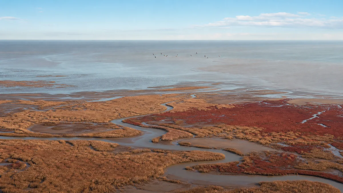
5A View location, maps and nearby scenic areasAt the first broad wetland view, do not look for a monument. Watch a channel instead. Brown-green water slides past reeds, a mudflat shines and disappears beneath a thin sheet of tide, and a bird you heard seconds ago finally lifts above the grass. The apparent emptiness is the event: river, sea, salt and living things are negotiating the map in front of you.
Many visitors arrive for the famous image of yellow river water meeting blue sea. It can happen, but the estuary is not a scheduled colour show. Suspended sediment, freshwater discharge, tide, wind, waves, light and haze decide whether the boundary looks dramatic, blurred or invisible. The better question is not “Where is the line?” but “What is moving today?”
Read the attraction in four bands: begin with the visitor and bird interpretation facilities, cross reed beds and shallow-water habitat, use a boardwalk or elevated lookout to read the tidal plain, then add the river-mouth or boat perspective only if current access and conditions allow.
Start by reading water moving in two directions
The Yellow River carries freshwater and fine sediment seaward. The Bohai Sea sends tides and waves landward. Where the two meet, neither simply wins. Current speed falls, grains settle, mud is lifted again, channels split, and salty water pushes inland to different degrees from one tide or season to another.
Look for evidence rather than a perfect panorama. A wrinkled mud surface records the last retreating water. A darker bank may have been wet recently. Floating reeds can reveal current direction, while lines of feeding shorebirds often trace the shallow edge more clearly than the water colour does.
From a high viewpoint, any brown-and-blue contrast is easiest to photograph with the sun at an angle rather than reflecting directly into the lens. From a boat, you may be too low to see a broad boundary even when sediment plumes are present. Never treat a promotional aerial image as the view guaranteed to a person standing at water level.
How the Yellow River makes young ground
A delta forms when a river delivers more material than waves and currents can carry away. Much of the Yellow River’s famous colour comes from fine mineral sediment eroded and transported through its basin. Near the mouth, slower water releases part of that load. Repeated deposits build shoals; shoals rise into intertidal flats; plants then trap more sediment and help stabilise patches of new land.
“Young” needs a timescale. The lower Yellow River returned to the Bohai Sea in 1855, beginning the modern deltaic phase around Dongying. The channel has not remained fixed. A major shift into the Qingshuigou course in 1976, followed by later adjustments, left a mosaic of active and abandoned delta lobes. Some edges advance through deposition while others erode after the main sediment supply moves elsewhere.
That is why one annual figure for “land created” is misleading. Upstream soil conservation, reservoirs and water regulation alter both flow and sediment; floods and water-sediment regulation events differ; storms and sea-level change work from the opposite direction. The coastline is a balance sheet, not a conveyor belt that produces the same acreage every year.
The tide can edit what the river writes
At low tide, exposed mud and shallow pools offer feeding ground to worms, molluscs, crustaceans, fish and the birds that follow them. As water rises, the feeding edge moves. Birds concentrate on the remaining flats, then retreat to islands, banks or managed ponds. A visitor who arrives two hours later may therefore encounter a completely different landscape without having come in a different season.
Freshwater and saltwater also create a shifting salinity gradient. Rain, river discharge, evaporation and tidal intrusion all affect where brackish conditions occur. This is why a place labelled “wetland” contains reed beds, salt marsh, open water, tidal creeks and bare flat rather than one continuous habitat.
Wind matters as much as a tide table to the experience. It can raise chop, push turbid water across the viewing area and suspend more sediment. Storm surge, fog, ice or high fire risk can close routes. Use forecasts and official notices to understand the day, but accept that an estuary remains only partly predictable.
Read the plants as a map of water and salt
The broad colour bands inland from the sea are a living contour map. Reeds favour wetter, fresher conditions. Tamarisk tolerates salt and drought and often forms low, wind-shaped scrub. Suaeda species occupy saline ground; some stands can turn red in autumn, although rainfall, salinity, plant health and timing make the display variable.
The sequence is not a neat textbook stripe. Old channels, embankments, ponds and water-control structures interrupt it. A few centimetres of elevation can decide how often a patch floods, and that changes which plants survive. Bare mud is not wasted space: for many shorebirds it is the dining table.
Do not walk onto red marsh or mudflat for a colour-block photograph. Salt crust can hide soft sediment, tidal channels can cut off the return, and trampling breaks the vegetation that slows water and holds soil. Use the designated boardwalks and overlooks; the separation that seems inconvenient is part of the habitat design.
A global migration route touches Dongying
The delta lies on the East Asian–Australasian Flyway, a chain of breeding, staging and wintering sites stretching from the Arctic through East and Southeast Asia towards Australasia. Birds do not use it as one uninterrupted highway. They depend on a sequence of wetlands where they can rest and replace energy lost in flight. Damage to one major stop can affect journeys thousands of kilometres long.
Oriental storks, Saunders’s gulls and red-crowned cranes are among the protected birds associated with the reserve, but none should be treated as a guaranteed sighting. Season, water depth, food, wind, disturbance and breeding status determine where birds gather. Start with shape and behaviour—long legs in shallows, a flock turning over mud, a raptor making smaller birds rise—before chasing a name.
In 2024, the Yellow River Estuary became one of five components added to UNESCO’s Migratory Bird Sanctuaries along the Coast of Yellow Sea–Bohai Gulf of China in its second phase. The listed habitat sits largely within the Shandong Yellow River Delta National Nature Reserve. The recognition is not a prize for scenic colour; it acknowledges habitat essential to migratory species.
The “wild” view depends on active protection
The national nature reserve was established in 1992 to protect the young wetland ecosystem and rare birds. Protection here is not simply fencing off land. Freshwater shortages, disconnected channels, invasive plants and earlier land uses have required active work: ecological water delivery, channel reconnection, conversion of some farmland and aquaculture areas back to wetland, habitat islands, monitoring and control of invasive cordgrass.
This is also Shengli Oilfield country. Roads, wells, salt production, aquaculture and settlements belong to the delta’s modern human history. Management has removed oil wells from core protection zones and is phasing out other incompatible uses, while allowing research, education and limited tourism in controlled areas. The clean horizon visitors enjoy is therefore partly the result of difficult choices about access, livelihoods and infrastructure.
Rangers, hydrologists, ornithologists and local residents all participate in this landscape. Artificial nesting structures can help Oriental storks where suitable natural sites are scarce; water-level management can expose feeding shallows; patrols reduce poaching and illegal nets. These interventions do not turn the reserve into a zoo. They show how much work is required when a dynamic estuary shares space with a large city and energy-producing region.
Move through a landscape too large to walk
The tourism zone covers long, flat distances, so plan it as a sequence of observation points rather than a continuous hike. Begin at the visitor facilities or bird museum to learn the habitat vocabulary and check same-day route information. Next, use authorised scenic transport towards wetland stops such as shallow-water bird habitat and the natural willow boardwalk, when open. Finish at an elevated river-mouth viewpoint, commonly associated with the Yuanwang Tower area, if the current circuit reaches it.
This order moves from explanation to evidence. The museum helps you recognise why different bill and leg shapes suit different feeding depths. The road then reveals how ponds, reeds, creeks and bare flats alternate. Height at the end lets you connect those fragments into one estuary.
Choose the land circuit for the most reliable, lower-impact overview. Add longer boardwalk stops if you value plants, insects and close habitat detail more than covering every named sight. Consider a boat only for a water-level reading of the channel and river mouth. Boat routes, boarding points and visibility can change with tide, wind, river conditions, maintenance and conservation controls; confirm them on the day.
Choose a season, not a promised spectacle
Spring can bring northbound migrants and fresh reed growth, but wind and rapidly changing weather affect both birds and boats. Summer makes wetland growth easiest to understand and can coincide with breeding activity, yet heat, humidity, insects and exposed roads demand water, sun protection and a slower pace.
Autumn is popular for southbound migration and changing marsh colour. The red tones of salt-tolerant vegetation vary by year and patch, and peak timing is not fixed. Winter opens long views through lower vegetation and can concentrate waterbirds, but coastal wind is severe, days are short, and ice or cold-weather measures may alter access.
Migration is a period, not a performance time. Even in the right month, birds may be feeding far from the road, resting behind reeds or absent after a weather front. Check recent reserve or attraction updates, bring binoculars, and let abundance be a bonus rather than the only definition of a successful day.
Photograph a habitat without consuming it
A telephoto lens is more useful than trying to approach wildlife. Include a strip of reed, mudflat or water around a bird: the setting explains why it is there and gives scale to the flock. For landscape images, use S-curves in channels, repeating nesting platforms or the contrast between low vegetation and a huge sky. A polarising filter can reduce glare, but it cannot create a river-sea boundary that conditions have erased.
Keep voices low, never use recorded calls to pull birds closer, and do not feed them. Stay out of closed breeding areas and do not launch a drone; protected-area and aviation controls are strict and can change. Ask before using tripods inside museums or on narrow boardwalks, where blocking passage is both inconsiderate and unsafe.
For limited mobility, the essential strategy is to reduce transfers. Ask the visitor centre which surfaced stops are open, whether an accessible vehicle can be arranged, and where step-free toilets are available. Boardwalk joints, boat gangways, wind exposure and long gaps between shelter may still present barriers. Everyone should carry water and wind or sun protection, keep away from soft tidal ground, and follow the last authorised transport rather than improvising a return across the reserve.
Leave with the horizon still unfinished
Return to the wide view before leaving. What first appeared empty should now be crowded with processes: silt settling, tide returning, roots holding a bank, birds measuring water depth with their legs, and people deciding how much of the delta to use or restore.
If the yellow-and-blue line appears, enjoy it as one brief expression of those forces. If it does not, the estuary has not failed. The more truthful souvenir is the recognition that a river mouth is a verb—building, eroding, flooding, feeding and changing even while you stand still.
The LoreLens app helps you read channels, plants and bird habitat in real time, turning a flat horizon into a map of river and tide.
Location profile
Where it is

Frequently asked questions
Can I definitely see a yellow-and-blue boundary where the river meets the sea?
No. A visible colour boundary depends on river discharge and sediment, the tide, wind, waves, light, haze and viewing angle. It may look sharp, faint or absent, and is often easier to understand from an elevated or boat viewpoint than from the bank.
When is the best time for birdwatching at the Yellow River Delta?
Spring and autumn commonly bring migration activity, while winter can be rewarding for waterbirds. Species, numbers and accessible areas vary with weather, water levels and conservation needs, so check recent official observations rather than planning around one promised bird.
Do I need a boat to visit the Yellow River mouth?
No. Wetland roads, interpretation stops, boardwalks and elevated viewpoints explain much of the estuary. A boat can add a water-level perspective, but routes may change or stop because of tide, wind, river conditions, maintenance or habitat protection.
Is the Yellow River Delta accessible for visitors with limited mobility?
Using authorised scenic transport can reduce the very long distances, and some main visitor facilities and surfaced viewpoints may be easier to use. Boardwalk transitions, exposed paths and boat access can still be difficult; ask the visitor centre about current step-free routes, toilets and vehicle arrangements.