Liaoning · Benxi
Wunü Mountain: Reading a Capital on the Clifftop
Climb from the Hunjiang River valley to a flat-topped mountain where cliffs, wall lines, water facilities and distant views reveal how an early Koguryo capital worked.
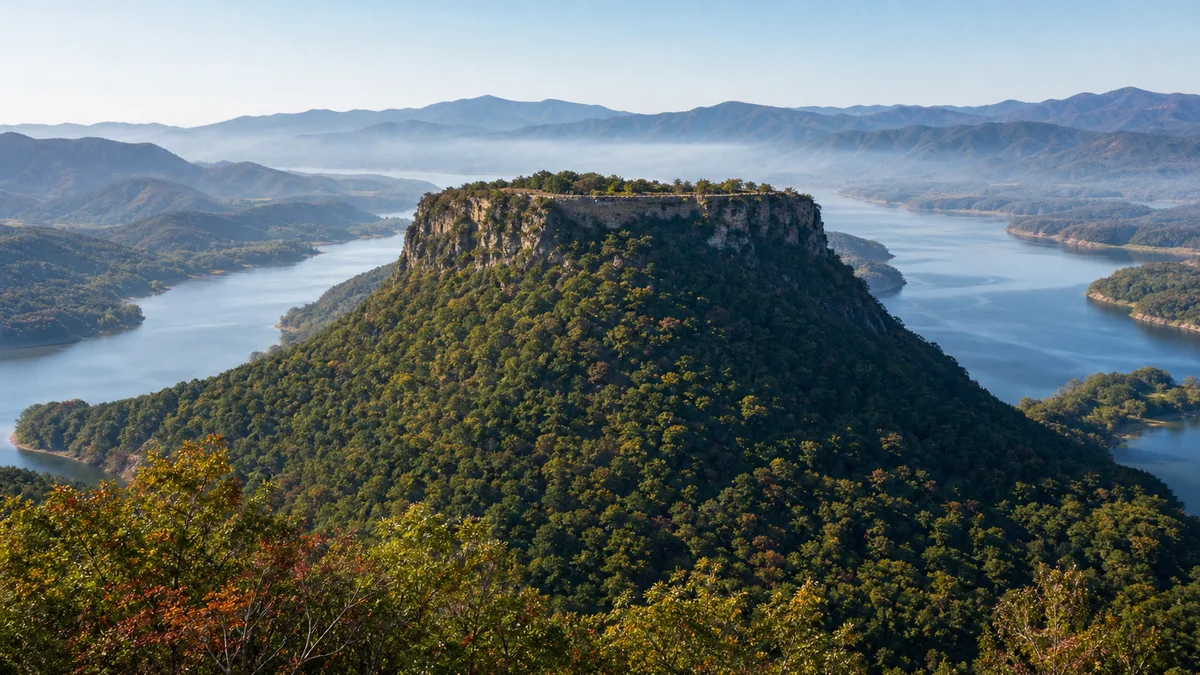
5A View location, maps and nearby scenic areasAt the top, the surprise is not only the height. It is the change in ground. After the stairs and steep wooded slopes, the mountain opens into a long, comparatively level terrace. Broken wall lines meet natural cliff edges; low foundations interrupt the grass; beyond them, the water of Huanlong Lake widens through the Hunjiang River valley. The landscape begins to read like a plan.
This is the best way to approach Wunü Mountain City: not as a ruined palace placed on a scenic peak, but as a settlement that made the entire mountaintop work. Cliff, plateau, gate, wall, spring or reservoir, lookout and building zone formed one system. The view is spectacular because the position was strategic; the position was habitable because people engineered access, water and protected space.
Look in this order: establish the cliff edge and summit terrace first, follow the wall where natural defence runs out, find controlled approaches and water features, then examine foundations. Only after that should you use labels such as palace, barracks or storehouse. The mountain explains the city before any single ruin does.
A table mountain above the Hunjiang River valley
Wunü Mountain rises northeast of Huanren in eastern Liaoning. Provincial cultural-tourism material gives the main summit an elevation of about 823 metres. Its steep flanks and flat-topped profile are much more informative than the number alone: a defender gained commanding views and difficult approaches, while the summit supplied room for occupation.
The broad water seen from high points is often promoted as Huanlong Lake. It is the reservoir landscape created on the Hunjiang River, not an untouched ancient lake that looked exactly the same to Koguryo inhabitants. Reservoir water has transformed the modern panorama and the valley’s scale. Distinguishing ancient topography from the present waterscape makes the view more, not less, interesting.
The official scenic area is broader than one archaeological enclosure. Current Liaoning material describes a 10.8-square-kilometre core comprising the mountain-city remains display area, natural-landscape area and Wunü Mountain Museum. A scenic-area ticket, a protected monument boundary and the inscribed World Heritage component therefore answer different administrative questions.
Use the Wunü Mountain 5A profile for map orientation and coordinates. Use the operator’s dated notice for the route actually open: forest fire controls, repair, ice, storms or rock safety can change summit access.
One component in a serial World Heritage property
The formal UNESCO name is Capital Cities and Tombs of the Ancient Koguryo Kingdom. Inscribed in 2004, this is a serial property: its significance rests on connected places rather than on Wunü Mountain alone. The components include Wunu Mountain City, Guonei City and Wandu Mountain City, together with royal and noble tombs.
Seen as a sequence, the sites show changing choices about capitals, mountain defence, urban space, architecture and commemoration. Wunü represents the early mountain-city solution; the later capital zone around present-day Ji’an combined a plain city with a mountain stronghold and extensive tomb landscapes. A visitor at Wunü is therefore looking at the opening chapter of a much larger spatial history.
World Heritage status does not mean every visible stone is two thousand years old or that the whole tourist park is archaeologically equivalent. UNESCO recognition protects the property’s outstanding universal value, authenticity, integrity and setting through defined boundaries and management. Modern stairs, rails, signs and visitor buildings enable access but do not become ancient fabric simply because they stand within the experience.
The 2004 inscription is only one protection milestone. Wunü Mountain City became a nationally protected cultural site in 1996; its excavations were selected among China’s major archaeological discoveries of 1999. The wider landscape also has forest-park and geological-park designations, while the scenic area received national 5A status in 2024. Each label evaluates something different.
Koguryo history without modern borders projected backward
UNESCO uses the spelling Koguryo; many English-language histories use Goguryeo. It was an ancient Northeast Asian polity whose territory at different times crossed areas now in China and on the Korean Peninsula. Wunü Mountain City is physically in present-day Liaoning, China. That geographical fact should not be turned into a claim that the ancient kingdom belonged exclusively to one modern nation.
The conventional chronology dates Koguryo’s foundation to 37 BCE. UNESCO’s narrative and traditional historical chronology place Wunü Mountain City at the beginning of the capital tradition, followed by a movement to Guonei around the beginning of the first century CE—traditionally dated to 3 CE. These dates organise textual and archaeological evidence, but they should not be treated like timestamps from a contemporary archive.
Texts preserve names rendered in English in several ways. Wunü is often identified with Jolbon, the first capital in Korean historical traditions, and Chinese scholarship also discusses transmitted names for the early capital. This is a common and meaningful identification, not an archaeologically incontestable equation between one ancient word and one set of walls.
What archaeology adds is material resistance to an overly neat story. Wall techniques, postholes, ceramics, hearths, water installations and layers of rebuilding can confirm occupation and change without making every literary episode visible. The site matters precisely because text, terrain and excavated evidence overlap but do not collapse into one another.
How cliff, wall, gate and water made a city
The builders did not surround a flat field with an identical wall on all sides. Near-vertical rock already formed a formidable boundary. Masonry was concentrated where the natural rim weakened, where approaches needed closing and where controlled entrances could be created. Follow the join between worked stone and bedrock: that seam reveals strategic economy.
A gate was not merely a gap. It compressed movement into a defensible route, channelled people and animals, and linked the steep exterior ascent to circulation on the terrace. Look for changes in slope and wall alignment rather than expecting a complete gate tower. The surviving ground plan may communicate control more clearly than a reconstructed façade.
Inside, the comparatively level summit could hold residential, administrative, storage and defensive activity. Official and site interpretation refers to foundations associated with palatial buildings, barracks, dwellings, sentry positions, lookouts and storage. These are functional readings of excavated patterns; most are not rooms preserved to roof height. Low stones need a plan, section or museum object to become legible.
Water was decisive. Springs, collection points, ponds or cistern-like facilities allowed people to remain on a height where carrying every container up the slope would be costly and a siege could cut access. Drainage mattered too: a flat summit must shed heavy rain without washing away occupation surfaces or undermining walls. Defence and daily life were the same engineering problem.
Learn to separate four kinds of visible fabric
At a conserved archaeological site, “original” and “new” are not the only categories. First is archaeological fabric—stone or soil features that survive from past construction and occupation. Second is conservation consolidation: discreet work that stabilises loose masonry, caps a wall or controls drainage while retaining old material.
Third is reconstruction, where a missing form is partly rebuilt to make volume or technique understandable. Reconstruction may be evidence-based, but it contains modern judgement and should be labelled. Fourth is visitor infrastructure: steps, guardrails, platforms, paths and signs designed for present safety and interpretation.
Colour alone cannot reliably separate them. Stone weathers differently, repairs age and old blocks may be reset. Instead, read joints, mortar, wall caps, tool marks, alignment and signage. Ask whether a section was excavated, stabilised or rebuilt, and whether the line under your feet is ancient circulation or a modern route across it.
Do not climb a wall for a photograph, move a loose stone into a “better” position or take a fragment. Even a displaced unworked stone can carry information through its layer and relationship to neighbouring material. Keep drones grounded unless the site’s current rules expressly authorise them; protected airspace, archaeology, wildlife and crowded lookouts all matter.
The “Five Women” belong to later place-memory
The modern name Wunü, literally “Five Women,” invites a story. Several local legends connect women with defence, loyalty, refuge or sacrifice, but their plots vary. It is better to treat them as later place-memory than to select one version and present it as the origin event proven by archaeology.
That distinction does not make legend disposable. A name can show how later communities domesticated a severe ruin, attached moral figures to a cliff and carried the site through periods when its early history was imperfectly understood. Oral tradition answers a different question from excavation: not “which wall was built in which phase?” but “why did people keep telling this mountain to one another?”
The site also lives across languages. Chinese uses 五女山城; Korean commonly uses 오녀산성 for the mountain fortress; Japanese writes the kingdom as 高句麗. English readers will encounter both Koguryo and Goguryeo. These variations reveal shared and sometimes contested memory. They are reasons to attribute claims carefully, not reasons to force the landscape into one modern national narrative.
Choose a short reading route or a long landscape route
A useful short visit begins with the museum or orientation displays, then concentrates on one controlled ascent, a representative wall or gate sector, a water facility and a major viewpoint. This sequence gives enough evidence to understand the mountain-city system without trying to collect every named rock. It is also the sensible choice in heat, uncertain weather or limited daylight.
A longer visit can extend along more of the summit edge and through additional building-foundation and natural-scenery zones. The reward is repetition: seeing several cliff-wall relationships shows that the defensive logic was systematic, while changes in view explain communication with the valley. The cost is more stairs, uneven ground and exposure.
Do not build the plan around a promised shuttle, a permanently open loop or a fixed ascent time. Internal transport, entrances and closures can change. Ask which route is operating, where the last return point lies and whether a one-way section requires extra climbing. Choose by the least-fit member of the group, not by a brochure’s “recommended duration.”
If possible, view the museum first and return briefly after the climb. Artefacts and diagrams are easier to place after seeing the terrace; the ruins are easier to read when pottery, construction methods and excavation plans are already in mind.
Weather changes both safety and interpretation
Secure-grip shoes matter more than fashionable hiking equipment. Expect long stair sequences, steep forest slopes, irregular paving and exposed rock. Carry water, sun protection and a layer for wind. Pace the ascent so that the summit remains an archaeological visit rather than merely a recovery stop.
Rain darkens masonry and can make construction joints easier to see, but wet leaves, roots, stone and metal steps become slippery. Snow and frost conceal edges. Fog removes the valley view and can make route-finding harder; it does not “ruin” the site, but it changes the evidence available. Thunderstorms are a reason to leave exposed rims and platforms, not an atmospheric photo opportunity.
Cliffs also mean rockfall risk. Respect barriers and temporary closures, avoid lingering directly below unstable faces, and never leave the marked path to reach a cleaner angle. After heavy rain or freeze-thaw weather, managers may narrow or close an area even when the lower park remains open.
Sunrise, clear reservoir views and brilliant autumn colour are possibilities, not deliverables. Visibility, leaf timing, fire precautions and opening hours vary. Confirm early-entry rules rather than assuming the gate will open for dawn, and prepare a museum-led visit if the weather removes the panorama.
Photography, access and archaeology etiquette
For photographs, use a person, wall line or path to show scale. A wide frame connecting terrace, cliff and reservoir explains more than an isolated “ancient stone.” Side light can clarify masonry, but do not step backward toward an edge or cross a barrier. Follow current tripod and drone rules; a quiet summit is not unregulated airspace.
Accessibility questions need site-specific answers. “A 5A scenic area” does not mean the mountaintop ruins are step-free. Ask whether the museum entrance and exhibitions are accessible, how far any vehicle-assisted segment reaches, what transfer is required, which viewpoints avoid stairs and where accessible toilets are located. A companion should not be treated as a substitute for safe infrastructure.
For visitors who cannot reach the summit, a good alternative is not merely waiting at the gate. Request a model, excavation plan, artefact display, film or reachable viewpoint that explains the cliff-and-terrace relationship. Confirm these options with the operator because exhibitions and routes change.
Within the ruins, keep to surfaced paths, leave wall stones and vegetation undisturbed, keep food away from exposed features and give excavation or monitoring staff room to work. Quiet attention is part of access: the site must remain readable for the next visitor and the next generation of research.
Conservation is a negotiation, not a frozen picture
Mountain settings protect and damage at the same time. Cliffs limited ancient attack and later construction, but rain, roots, frost, runoff and gravity continually loosen masonry and erode occupation layers. Concentrated footsteps compact soil and create shortcuts; crowds at viewpoints pressure exactly the narrow edges that carry both views and remains.
Managers face real trade-offs. A stronger wall cap may prevent water entry but look too new. A raised walkway protects archaeology but changes the view. Clearing vegetation reveals a wall while exposing soil and removing root systems; leaving everything wooded can hide and disrupt masonry. Repair should be documented, minimal where possible and distinguishable on close inspection without turning the site into a patchwork display.
Visitors participate in that negotiation. Staying on the route, accepting a closure and not demanding an unrestricted cliff photograph are conservation actions. So is reading modest foundations instead of requiring a full palace reconstruction. Authenticity often survives as relationships—wall to bedrock, building to terrace, city to valley—rather than as tall architecture.
At the final viewpoint, look back across the summit before looking outward. The low remains may initially seem less dramatic than the reservoir. Yet the enduring achievement is the fit between them: an ancient community turned a difficult mountain into defensible, supplied and organised space. World Heritage protection asks modern tourism to keep that fit legible, even when doing so limits where we may stand.
The LoreLens app can help distinguish ancient fabric, conservation work, reconstruction and modern visitor infrastructure while you read the mountain-city landscape.
Location profile
Where it is

Frequently asked questions
Why is Wunü Mountain City a UNESCO World Heritage site?
It is one component of the UNESCO property Capital Cities and Tombs of the Ancient Koguryo Kingdom, inscribed in 2004. Together with Guonei City, Wandu Mountain City and royal and noble tombs, it preserves evidence for the development of Koguryo capitals, architecture and burial culture. The World Heritage boundary and the wider tourist scenic area are not necessarily identical.
How difficult is the climb at Wunü Mountain?
Expect sustained stairs, steep gradients, uneven stone and exposed viewpoints rather than a level heritage walk. The amount of climbing depends on the route and any transport operating that day. Ask the operator which summit sites are open, choose a shorter or longer circuit according to fitness, and allow extra time after rain, snow or frost.
Is Wunü Mountain City the same place as Jolbon?
It is commonly connected with the first Koguryo capital named in textual traditions and is often identified with Jolbon. UNESCO presents Wunu Mountain City as the first capital in the Koguryo capital sequence, but an exact equation between a transmitted place-name and one archaeological site should be described as an identification, not as an uncontested fact.
Can visitors with limited mobility see Wunü Mountain City?
The summit archaeology involves steep stairs, slopes and uneven ground, so it may not be reachable for every visitor. Ask the operator about the current route to the museum, any vehicle-assisted section, step-free viewing points and transfer requirements. If the summit is unsuitable, request an accessible exhibition or interpretation alternative rather than assuming every labelled facility reaches the ruins.