Liaoning · Anshan
Qianshan: Reading Peaks, Temples and Stone Paths
Look past a flight of stone steps to granite ridges and temple roofs: Qianshan is a many-valley sacred landscape where Buddhist and Daoist traditions still share the mountain.
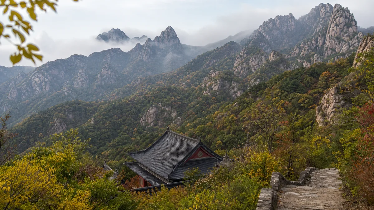
5A View location, maps and nearby scenic areasAt the first open bend, stop and look through three layers. Nearest are stone steps, polished at the centre by feet. Above them, dark temple roofs settle into a wooded hollow. Higher still, bare crests repeat into the distance, each ridge hiding another valley.
That layered view is Qianshan. It is not one summit with one standard ascent, but a granite-dominated mountain system southeast of Anshan, threaded by Buddhist monasteries, Daoist temples, historic paths and modern visitor routes. To understand it, keep shifting scale: from a worn step to a roofline, from one shrine valley to the apparent “thousand” peaks beyond.
Look in this order: trace the joints dividing a rock face; see how steps use the easiest break in the slope; find where a temple turns its entrance towards a valley; then decide whether your remaining energy belongs to another hall or a higher ridge. At Qianshan, route choice is part of interpretation.
Why “Thousand Mountains” is not a headcount
The name has a firmer history than its most popular explanation. Qianshan’s own historical summary notes a reference to “a thousand peaks” by the Jin-dynasty writer Wang Ji and identifies a 1304 inscription as the earliest known surviving written use of “Qianshan.” Later texts and carvings also used names such as Qianhuashan, Thousand Lotus Blossom Mountain and Jicuishan.
Local tradition says there are 999 peaks; some retellings imagine the final one needed to complete a thousand. That is a memorable origin story, not an audited inventory. What counts as a separate peak changes with the prominence threshold, map scale and boundary chosen. “Thousand” works better as a literary statement of abundance.
The lotus name is also a way of seeing. From a broad viewpoint, clustered pointed summits can resemble buds and petals. The comparison has shaped poetry and religious imagination, but granite ridges do not form by turning flowers into stone. Keep the two readings together without confusing them: a mountain form can inspire a lotus image while retaining a geological history of its own.
The Qianshan 5A scenic-area profile provides the mapped location. Its pin marks an entrance to a much larger network, not the position of every temple or summit.
How granitic rock becomes a forest of peaks
Qianshan’s exposed crests are widely described as a granitic landscape. “Granite” is useful at visitor scale, although a precise geological map may distinguish related rock types and separate bodies. It is safer to read the visible structure than to assign one unsupported age to the whole mountain.
Look for joints cutting the pale rock into blocks. Water enters these fractures; chemical weathering works along them; winter freezing can widen loosened cracks; runoff carries away altered material; and gravity removes unstable blocks from steep faces. Curved sheets, upright slabs, narrow clefts and balanced-looking forms emerge because spacing and orientation of the fractures vary.
The vegetation helps reveal the process. Pines anchor into cracks where soil has collected, while smooth exposed faces remain bare. A gully often follows a zone of weakness, and a stair builder follows the same route because it offers a passage through the rock. Temple siting and trail engineering are therefore not separate from geology: both respond to the available ledges, water and shelter.
Popular accounts sometimes give a single immense age for “Qianshan” or credit one ancient glacial episode with its present shapes. Rock crystallisation, later uplift, jointing, deep weathering and today’s slope processes occur on different timescales. Without a clearly identified sample and method, one number should not stand for the entire landscape.
Buddhism built institutions into the valleys
Qianshan is traditionally associated with five major Chan Buddhist monasteries: Longquan, Zuyue, Da’an, Zhonghui and Xiangyan. Their collective label helps organise history, but a visitor learns more by reading one place closely than by racing through five names.
At Longquan Temple, buildings occupy a sheltered valley beneath rock and old trees. The mountain is not a painted backdrop: halls, walls and paths adapt to narrow ground and changes in elevation. Scenic-area historical records credit the monk Zongyun with converting an earlier cave site into a hall in 1571, then expanding the temple with his disciple Huicong in 1578. Later rebuilding means the date of one foundation is not the date of every timber, tile or statue now visible.
Longquan also preserves a secular scholarly layer. Wang Erlie, an eighteenth-century Liaodong scholar and official, is associated with a study here. That small room changes the story from “monks in remote mountains” to a wider network in which clergy, literati, patrons, artisans and pilgrims moved through the same valley.
Today a Buddhist temple may contain worshippers, resident clergy and services that are not staged for sightseeing. Listen before speaking, give ritual movement priority, and do not treat a closed hall as an exhibit withheld from a ticket-holder.
Daoism took a neighbouring, not identical, path
The clearest Daoist anchor in the northern core is Wuliang Guan, a Quanzhen Daoist temple complex set into steep rock and woodland. Qianshan’s official history gives 1667 as the beginning of an institutional Quanzhen presence under the Daoist Liu Tailin and the establishment of Wuliang Guan.
Yet the same source points to images of immortals at Xianrentai recorded by the mid-sixteenth century. The evidence therefore suggests Daoist imagery and influence before the better-documented Qing institutional expansion. “Daoism arrived in one year” is too simple; 1667 is useful as an organisational milestone, not necessarily the first Daoist idea ever carried into the mountain.
Buddhist and Daoist sites share paths, springs, donors and a mountain setting, but that does not make them one blended religion. Their deities, lineages, liturgies and institutions differ. The remarkable feature of Qianshan is long proximity: a visitor can cross a ridge and enter another religious vocabulary without leaving the same landscape.
Architecture makes that distinction visible. Compare a hall’s dedicatory plaque, altar figures and ritual objects rather than assuming every incense burner belongs to the same tradition. If unsure, use the site’s own name—si for a Buddhist temple, guan or gong commonly for Daoist establishments—and let current custodians explain the rest.
A mountain outline becomes Maitreya
At the designated viewpoint for the Natural Maitreya Buddha, first observe without the label. Find the head-like rise, the broader torso, the slope interpreted as folded limbs, and the shadows or vegetation that complete the outline. Move away from the intended viewing position and the figure becomes less obvious. That dependence on angle is part of the phenomenon.
Geologically, this is a mountain profile produced by rock structure, weathering, erosion and vegetation. Religiously, devotees recognise Maitreya, the future Buddha, in the seated form. Institutionally, the resemblance has been named and interpreted as a sacred site; former Buddhist Association of China president Zhao Puchu provided the calligraphy “Qianshan Maitreya Buddha.” These are three valid but different statements.
The operator describes the figure as about 70 metres high. Such a measurement depends on where interpreters draw the outline. Promotional descriptions calling it the world’s largest natural Buddha likewise depend on definitions of “natural,” “figure” and boundary; they are not a universal geological ranking. Nor does resemblance alone prove a precise date or single process for the profile. See it as a meeting between landform and religious perception, not as a statue secretly carved by nature.
Living practice and mass tourism share narrow ground
Qianshan’s religious buildings survived through repair, loss, rebuilding and changing patronage. Preservation cannot mean freezing every hall at an imagined “ancient” moment. Roof tiles need replacing, worship spaces need heating and fire prevention, and communities need rooms not open to casual visitors.
Tourism brings funds and attention, but steep sacred valleys have limited space. Crowding can interrupt worship, incense and candles require fire controls, and desire for a better photograph can damage stone, trees or historic fabric. Modern stairs, railings, cableways and transport reduce some risks while adding visible infrastructure to the landscape.
Accepting limits is part of the visit. A barrier may protect a weathered carving or unstable ledge; a photography ban may protect ritual privacy; a closed hall may be in use. Never tie ribbons to trees unless a site explicitly manages that practice, scratch names into rock, stack stones or touch sculptures. The mountain does not become more spiritual when visitors leave material behind.
Choose depth in the valley or distance on the ridge
For a shorter, lower-level visit, choose one religious complex—often Wuliang Guan or Longquan Temple—and pair it with nearby rock forms and a modest viewpoint. Read the roof-to-slope relationship, rest before the descent and resist adding a summit simply because a sign points upward. This route can still involve many uneven steps.
For a longer mountain day, one official route concept links Wuliang Guan, the rugged Tianshangtian area, Longquan Temple and the Maitreya area. Treat that as a framework, not a guaranteed through-route. It trades close architectural reading for more ascent, exposed ridges and repeated descents. Another distant goal, Xianrentai, is Qianshan’s highest summit at roughly 709 metres, but it belongs to a more demanding sector and should not be bolted onto a northern-core walk casually.
Cable cars or internal vehicles can reduce part of the climb when operating; they do not erase steps between stations, temples and viewpoints. Ask which line and trail each service actually connects, whether the route is one-way, and what return option remains if wind or maintenance stops operation. Never make an uphill decision that depends on an unconfirmed ride down.
Weather turns stone steps into a different route
Dry granite can provide excellent friction; the same worn step becomes slick with rain, frost, leaves or packed snow. Narrow clefts remain damp, shaded stairs hold ice after open ground has thawed, and strong wind is more serious on a crest than at the gate. Summer heat and humidity increase water needs; thunderstorms make exposed ridges a poor place to wait.
Check the mountain forecast and current trail notice, then reassess at every junction. Clouds may hide distance without producing a “sea of clouds”; sunrise, autumn colour and snow scenery are possibilities, not scheduled attractions. After heavy rain, freeze–thaw or storms, rockfall controls may close apparently usable paths. Do not pass a barrier because other hikers do.
Carry water, keep hands free on steep sections and use footwear with reliable grip. Descending punishes knees and concentration; turn back while you still have balance in reserve. In winter, traction aids may help only where permitted and used correctly—they do not make a closed route safe.
Lower paved approaches and some transport-assisted areas may be usable by visitors with limited mobility, but historic compounds often contain thresholds, narrow gates and steps, while ridge trails are not step-free. Ask the visitor centre for the current least-stepped route, accessible toilets and boarding assistance. “Cable car available” is not the same as an accessible end-to-end visit.
Photograph with the manners of a guest
The most revealing landscape frame contains all three opening layers: a close stair or pilgrim, a temple roof in the middle distance and bare peaks beyond. Use a moderate telephoto lens to compress them. A wider view from the permitted path shows how little buildable ground a monastery occupies. Mist can simplify the ridges, but visibility cannot be ordered in advance.
Inside a religious compound, lower your voice and watch before raising the camera. Do not photograph worshippers, clergy, memorial tablets or ceremonies closely without permission. Avoid flash around paintings and statues, obey no-photo signs and never block a doorway or circumambulation route. Ask before using a tripod or drone; mountain, heritage and fire rules can change.
Before leaving, look back down one flight of steps. It is easy to remember only the summit count or a Buddha-shaped silhouette. The fuller Qianshan is in the alignment: fractured rock created a passage, generations laid and repaired a path, religious communities gave the valley meaning, and present visitors negotiate how lightly to pass through it. The mountain is not one claim to conquer. It is a relationship among stone, practice and movement.
The LoreLens app helps distinguish granite joints, historic architecture and religious interpretation on site, then keeps legends visible without turning them into measurements.
Location profile
Where it is

Frequently asked questions
Does Qianshan literally have 999 peaks?
The 999-peak count belongs to local tradition and poetry, not a fixed modern topographic survey. The name Qianshan is historically documented—an inscription dated 1304 is the earliest known written use cited by the scenic-area history—but explanations involving exactly 999 peaks or a missing thousandth should be treated as legend.
Is Qianshan a Buddhist or Daoist mountain?
It is both, while the two traditions remain distinct. Buddhist Chan monasteries and Daoist Quanzhen temples developed in neighbouring valleys and on ridges over centuries. Some are active religious communities, so a visit combines architecture and hiking with worship, ritual and ordinary monastic life.
How difficult is hiking at Qianshan?
Difficulty varies widely. A lower-valley visit can focus on a temple and nearby viewpoints, while ridge routes include long flights of uneven stone steps, steep gradients, narrow passages and sustained ascent. Choose from the current official map, keep reserve energy for the descent and turn back before fatigue affects balance.
Can I rely on a cable car or shuttle for the return?
No. Cable cars, internal vehicles and individual trail sections may stop because of wind, ice, maintenance, visitor controls or seasonal operations. Confirm the day's service before climbing, note the last available return arrangement and keep a walking alternative that matches your ability.