Jiangxi · Pingxiang
Wugong Mountain: Read the Meadow Before the Summit
Walk the Pingxiang side from forest and stone steps to an exposed summit meadow, while separating the managed 5A visit from multi-jurisdiction Wugong range traverses.
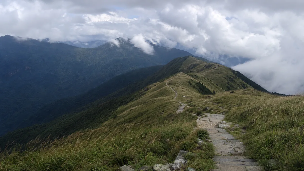
5A View location, maps and nearby scenic areasStand near the grass slopes below Jinding, the Golden Summit, and look at what the wind is doing before looking at the view. Grass blades flatten in one direction, cloud wipes out the next bend, and damp stone steps shine under boots. A few metres away, tent platforms and repaired paths show that this apparently open highland is also a carefully used visitor landscape.
This guide is about the Pingxiang-side Wugong Mountain National 5A Scenic Area in Jiangxi. It is not a promise that one gate, one ticket or one ropeway system opens the entire Wugong mountain range. That distinction matters most when a social-media route continues beyond the managed day-visitor circuit.
Orient yourself in three layers: the Pingxiang scenic-area entrance and transport system; the exposed Jinding summit zone; and the much wider range, where long traverses may cross other entrances and jurisdictions. Decide which layer you are actually visiting before buying transport or reserving a tent.
Draw the boundary before drawing the route
Wugong Mountain is both a mountain range and the name used by several tourism areas. The range extends beyond Pingxiang toward areas administered from Anfu/Ji’an and Yichun. Popular long-distance itineraries may link village trailheads, high ridges and sections managed under different local rules. A line that looks continuous on a hiking app is not necessarily one continuous park operation.
The national 5A designation discussed here belongs to the managed scenic area on the Pingxiang side. Its visitor centre, shuttles, ropeways, signed paths and emergency procedures form one practical system. A through-hike can leave that system. Once it does, admission, registration, open-trail status, camping permission, transport and rescue contacts may change.
Do not assume that a Pingxiang ticket covers a gate in Anfu, that a ropeway ticket includes another operator, or that a campsite reservation authorizes an entire ridge traverse. Before a cross-range trip, obtain a current route trace from the relevant operators, identify every entrance and exit in Chinese, and confirm which authority manages each overnight section. Offline maps are a backup, not evidence that an unmarked shortcut is legal or safe.
For an ordinary first visit, remaining within the signed Pingxiang circuit makes the day’s choices clearer. The wider range can still be understood from the ridge, but it deserves a separate expedition plan rather than an accidental extension after the last cableway.
The meadow is seasonal, exposed and maintained
The high grassland is Wugong Mountain’s defining image, yet it is not a carpet guaranteed to stay bright green. Spring growth, summer moisture, autumn colour, winter dormancy, drought, frost and occasional snow all change its tone and density. Cloud can hide it; strong sun can bleach it; recent rain can turn a photogenic path into a slippery channel.
Terrain helps explain why open grass persists. Broad rolling ridges receive wind from several directions, while shallow, weathered soils and exposure make tree establishment harder than in sheltered valleys. Water can drain quickly from a convex crest yet collect in small depressions. The result is a mosaic of grasses, low plants, wet hollows, bare soil and repaired tread—not one uniform lawn.
Human use also belongs in the explanation. Historical grazing and burning practices may have influenced parts of the highland, while modern hiking, camping and concentrated foot traffic add trampling and erosion. Current mowing, fire management, trail hardening, seasonal closure and vegetation restoration can alter what visitors see. Without a site-specific study for each slope, it is too simple to call every meadow entirely untouched nature or entirely human-made.
Stay on durable, open surfaces. Cutting a corner saves seconds but widens the scar when thousands repeat it. Do not pick plants, dig drainage around a tent or pour food and detergent into a hollow. The grass returns seasonally; compacted high-elevation soil may recover much more slowly.
Jinding is a summit zone, not every viewing deck
Public descriptions commonly give Wugong Mountain’s principal summit an elevation of about 1,918 metres, frequently 1,918.3 metres. They also use the names Baihe Peak and Jinding—White Crane Peak and Golden Summit—sometimes for the same principal summit area and sometimes with slightly different emphasis. A current on-site map is more useful than forcing every source into one naming system.
The number belongs to the actual summit or surveyed high point represented by that source. It does not make every square, monument, weather station, camping platform or viewpoint labelled “Jinding” exactly 1,918.3 metres high. Nor should a photograph of a summit marker be used to assign an elevation to a nearby terrace.
The same caution applies to the whole range. A range-wide statement about its highest point and a scenic-area statement about a visitor platform answer different questions. Follow the route markers when navigating, and treat the widely printed elevation as an approximate orientation unless an official sign identifies the precise benchmark in front of you.
Look beyond the marker. The rounded crest, steeper flanks and chains of saddles explain why a point that seems close may still require descent and another climb. Fog removes that depth. In poor visibility, distance on a phone screen is less important than the next confirmed sign and the time needed to return.
Sacred layers are older than some visible walls
Wugong Mountain has accumulated ritual associations over centuries. Local histories and traditions connect different summit and slope sites with Daoist practice, Buddhist worship, popular devotion and seasonal pilgrimage. Names, altars, small temples and offerings can therefore overlap rather than fit one clean institutional label.
Traditions linking the mountain to early religious figures are culturally important, but they are not all equally documented as biographies. A local story that a named adept cultivated here should be introduced as tradition unless supported by a dated inscription or reliable text. Religious history is often a chain of memory, patronage, loss and renewal rather than a single founding moment.
The buildings visible today also have mixed fabric. Some sites may preserve older foundations, stonework, inscriptions or ritual locations; roofs, walls, statues, paths and service structures may have been repaired or rebuilt after fire, weather, abandonment or tourism development. “Ancient sacred site” does not mean every beam is an untouched ancient original. Conversely, reconstruction does not automatically erase living religious meaning.
At an active shrine, keep entrances clear, lower your voice and follow posted photography rules. Do not sit on an altar base, move an offering for a composition or aim a bright light at worshippers. At night, a headlamp pointed down preserves both ritual quiet and other hikers’ vision.
A borrowed poem can still teach honest looking
A couplet praising Wugong Mountain is widely attributed in tourism writing to the Ming traveller Xu Xiake, author of celebrated travel diaries. The attribution often circulates without a stable chapter reference or verifiable original passage. Until a reliable primary-text citation is supplied, it is better described as a common tourism attribution, not confirmed wording from Xu’s diary.
For a securely transmitted classical line, borrow instead from Tang poet Wang Wei’s “My Retreat at Mount Zhongnan”: “I walk to where the water ends, and sit to watch the clouds arise.” Wang Wei was writing about Zhongnan, not Wugong Mountain; this is explicitly not a local Wugong ode.
Its story is a change of plan. The walker follows water until the path seems exhausted. Rather than treating the dead end as failure, he sits, and the same water reappears in another state as cloud. The poem turns blocked motion into attention. That is why it survives beyond its original mountain: it offers a way to respond when an itinerary stops controlling the landscape.
Its modern echo is visible in Wugong’s outdoor culture, though with a contradiction. Hikers come for unhurried ridge space, then crowd a sunrise rail or chase a viral cloud forecast. The older lesson is gentler: when fog cancels the horizon, notice grass bending, water beading on a handrail and strangers making room on a narrow step. The mountain need not deliver the promised photograph to make the walk meaningful.
Choose a route by what you can safely finish
The Pingxiang scenic area commonly operates lower and upper ropeway sections rather than one uninterrupted ride to the summit. Their stations are separated by walking routes, stairs and a transfer; names, combinations, opening status and last-car times should be checked on the dated official notice. Buying two tickets does not remove all climbing.
A ropeway-assisted summit day suits visitors who want the meadow and summit zone while limiting lower-slope ascent. It still includes exposed paths, queues and stairs, and the return margin must include the transfer between sections. A partial-ropeway route adds more forest and vertical change but demands more time and knees. A full walking ascent is a mountain hike, not the free version of the same easy tour.
Boardwalks, stairs and one-way diversions are operating infrastructure too. Ice, storm damage, repairs or crowd control can close a short link and change the whole circuit, so a route shown on an undated post remains conditional until staff confirm it.
Long traverses toward Fayunjie, village trailheads or other sides of the range are separate undertakings. Distances posted by users may omit ascent, mud, navigation, permit changes and the road journey after an exit. Do not attach one of these routes to a late Jinding visit simply because the ridge appears continuous.
Set a turnaround time before climbing. Ask staff which descent paths and ropeways are operating, save the Chinese names of your intended stations, and carry enough light to walk if a delay occurs. If wind stops a ropeway or a companion becomes cold, the correct route is the one that ends safely—not the one that completes a screenshot.
Camping and night climbing change the social landscape
Camping platforms and sunrise crowds have become part of Wugong’s public image. Availability is still conditional. Authorized camping zones, tent rentals, reservations, fire rules, toilet access, quiet hours and waste systems can change with weather, maintenance and crowd control. A tent pitched outside a permitted area damages vegetation and may sit directly in an exposed wind channel.
High-ridge wind can flatten or tear a poorly anchored tent, while condensation and falling temperature make a mild evening feel much colder before dawn. Keep sleep gear dry, separate cooking flames from fabric, and never use charcoal or an unsafe stove in a sealed tent. Carry water according to current supply information; do not rely on a seasonal stall being open overnight.
Night ascent is not simply the daytime trail with fewer views. Depth perception shrinks, route junctions become harder to read, wet stone reflects light and fog can return the beam into your eyes. Use a headlamp with spare power, remain on the signed route and avoid setting out alone merely to secure a front-row sunrise position. If access is suspended, do not follow an old online track around a barrier.
Night etiquette protects sleep, worship and safety. Keep speakers off, use a low voice near tents and shrines, angle light below faces, and avoid repeated flash. Pack every battery, food pouch and disposable rain cover down. Sunrise is weather; litter is a choice.
Weather, crowds and descent are part of the route
An exposed ridge amplifies ordinary forecasts. Thunderstorms make summits, rails and open grass dangerous; descend from exposed ground and follow staff instructions rather than filming lightning. High wind affects balance, tents and ropeways. Low temperature can combine with sweat and rain to cause rapid chilling even when Pingxiang below is warm.
Dense fog removes junctions and cliffs from view. Wet stone and timber become slick. Strong ultraviolet exposure and sun can cause dehydration and burns even in cool air. Carry layers that work together: sun protection, water, food, a waterproof shell and insulation, not one heavy coat that becomes soaked during the climb.
Crowds change risk as surely as weather. At a bottleneck, do not overtake outside the rail or stop in the centre for a portrait. Give descending hikers space, keep children away from edges and wait for a stable position before using a phone. If crowd control introduces a one-way route, it overrides the itinerary saved on your device.
Plan the descent while still fresh. Know the last operating transport, but never treat it as a rescue guarantee; wind, lightning, inspection or congestion may interrupt service. If you are lost, injured or severely chilled, stop compounding the problem, identify the nearest numbered sign or landmark, and contact scenic-area staff or emergency services with your location.
Photograph scale without demanding a performance
For the meadow, a side-lit ridge can reveal overlapping folds better than a close crop of grass. Include a path, person or handrail to explain scale and visitor pressure. In fog, work with nearby layers instead of crossing a barrier for an imaginary clear patch. Cloud sea, rime, sunrise and a green summit are conditions, not products included in admission.
Tripods and drones can obstruct paths or conflict with current restrictions. Confirm rules before use, yield to walkers and never anchor equipment in vegetation. Near tents, ask before photographing identifiable people; near shrines, respect posted limits and ongoing worship. A dark sky does not cancel privacy.
Accessibility is uneven. Visitor-centre services, shuttles and ropeways can remove large amounts of ascent, but transfers may still involve steps, sloping pavement, queues, narrow boardwalks and exposed summit terrain. A wheelchair-accessible lower facility does not prove a step-free route to Jinding. Ask the operator specific questions about boarding help, accessible toilets, transfer distance and the highest point reachable without stairs.
Visitors with limited stamina can make a complete visit by choosing a lower forest section, one transport stage or a weather-safe viewpoint. The meaningful measure is not the summit marker; it is whether the route leaves enough attention to see where forest yields to wind and grass.
Leave the ridge with its limits intact
Return once more to the bent grass beside the stone steps. It records altitude, weather, trampling and repair at the same time. Wugong Mountain is most legible when it is neither reduced to a green wallpaper nor expanded into a ticket that supposedly owns the whole range.
Check location and coordinates in the Wugong Mountains 5A profile, then compare exposed mountain choices at Mount Hua, higher alpine conditions at Mount Taibai, and the meeting of living Daoist tradition with rebuilt summit architecture at Mount Laojun. Each mountain rewards the same discipline: know which landscape and operating system you have actually entered.
Location profile
Where it is

Frequently asked questions
Does a Pingxiang Wugong Mountain ticket cover the whole mountain range?
No. This guide focuses on the National 5A scenic area on the Pingxiang side. The wider Wugong range reaches across different jurisdictions, and popular through-hikes may use village trailheads or routes toward Anfu/Ji'an and Yichun. Admission, gates, ropeways, camping rules and rescue responsibility can therefore differ by section; confirm every segment rather than treating one ticket as a range-wide pass.
How high are Jinding and Baihe Peak on Wugong Mountain?
Visitor information commonly associates the principal summit zone called Jinding, or Golden Summit, with Baihe Peak and an elevation of about 1,918 metres, often written 1,918.3 metres. Names and the exact point represented can vary between maps. Follow current route signs and do not transfer the summit elevation to every terrace or viewpoint bearing a similar name.
Do the cableways take visitors directly to the highest point?
Not as one continuous ride. The Pingxiang-side system is commonly described in lower and upper sections, with walking, stairs and a transfer between them; operations, ticket combinations and last rides can change. Even after using both operating sections, exposed walking and climbing remain before or around the summit zone.
Can I camp or climb at night on Wugong Mountain?
Only when the current scenic-area rules, weather and your experience allow it. Use an authorized campsite or route, register or reserve if required, carry a real headlamp and warm waterproof layers, and keep a descent alternative. High wind, lightning, fog, crowd controls, fire rules or maintenance can suspend camping and night access even when older trip reports say they were available.