Shaanxi · Weinan
Mount Hua: Granite Ridges, Sacred Paths and Safer Choices
Read Mount Hua's five granite peaks, Daoist temples and historic stairways, then choose among walking and cable-car routes without turning optional cliff attractions into tests of courage.
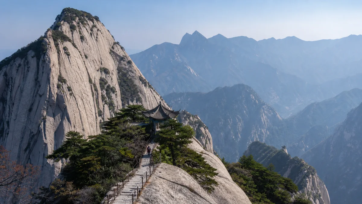
5A View location, maps and nearby scenic areasStand at the foot of a pale granite wall and follow the stone steps until they disappear above your head. Some are cut into bedrock, others laid or repaired on top; iron chains trace the safest human line between cliffs. Above, ridges divide toward five named peaks, but from inside the gorge the mountain rarely reveals the whole plan at once.
This is Mount Hua, or Huashan—roughly “hwah-shahn”—near Huayin in Shaanxi’s Weinan municipality. It is famous for steepness, Daoist sacred geography and modern cable-car access. Those three facts belong together. Granite joints and erosion created dramatic relief; generations of pilgrims and workers made a route through it; tourism engineering now changes who can reach high ground and how.
Choose an effort budget before a peak list. Decide whether your priority is a historic stair ascent, the North-to-high-peaks progression, a shorter visit to the West/South/East cluster, or simply one safe summit view. Cableways reduce climbing but do not remove transfers, queues, steps, weather or the need to descend.
Granite sets the shape; stairs reveal the route
Mount Hua rises from the eastern Qinling region as a steep granitic mass divided by joints, gullies and narrow ridges. Weathering exploits fractures, while water, gravity and freeze-thaw processes help detach blocks and deepen channels. One mechanism or one dramatic earthquake does not explain every cliff.
Look at texture before scale. Pale, crystalline rock appears smooth from a distance but breaks into slabs, corners and coarse grains close up. Pine roots occupy cracks; rain darkens the surface; polished steps record countless shoes. A broad summit slab can end abruptly where a joint-guided face drops away.
Historic route makers used the mountain’s weaknesses and strengths. They cut footholds where solid rock permitted, built steps across broken ground and fixed chains where hands improve balance. Modern crews added drainage, railings, signs, lighting and replacement surfaces. The resulting path is neither purely natural nor an ancient object preserved without change.
The Mount Hua 5A profile marks the mountain on a map. On the ground, vertical distance matters more than straight-line distance. A nearby peak may require descent to a saddle and another sustained climb; a cable-car upper station is not the same thing as arriving at every summit.
Five peaks are a map of experience, not five separate mountains
The visitor map organizes Huashan around North, Central, East, South and West peaks. North Peak is commonly called Cloud Terrace; Central Peak, Jade Maiden; East Peak, Facing Sun; South Peak, Wild Goose Landing; and West Peak, Lotus. The names combine orientation, profile, story and religious imagination.
South Peak is generally given as about 2,154.9 metres above sea level, the highest of the five. Sources may round elevations differently or use different survey references and summit points. That number is elevation, not the vertical height of one cliff and not the amount every visitor climbs from an entrance.
The peaks are also unequal as route units. East, South, West and Central form a high cluster linked by stairways and saddles; lower North Peak stands on the main progression from the traditional ascent. Visiting all five therefore means repeated height gain and loss rather than a level circuit.
Do not let counting replace observation. East Peak’s name directs attention to morning light, West Peak’s outline invites lotus comparisons, and South Peak provides the highest measured ground. Weather can erase all three associations. One peak seen clearly can be a more complete mountain experience than five signs reached inside cloud.
“Western Sacred Mountain” came before a tourist brand
Huashan is the Western Sacred Mountain, Xiyue, within the Chinese tradition of Five Great Mountains. State worship of the mountain and its deity developed across imperial history, while Daoist institutions, immortality traditions and reclusive practice added overlapping sacred meanings. It is inaccurate to reduce every old ritual here to one timeless form of Daoism.
Temples, shrines, caves and inscribed places turn topography into moral and cosmological space. Buildings have been repaired, replaced and reorganized; an ancient dedication does not guarantee that every visible beam is ancient. At the foot, sites such as Xiyue Temple and Jade Spring Temple can provide context, but admission and transport may be separate from the summit day.
The recluse and Daoist figure Chen Tuan, active around the transition from the Tang to Song periods, is strongly associated with Huashan. Later stories enlarged his image as a sleeper, sage and master of inner cultivation. Treat documented association and colourful legend as related but different evidence.
Huashan remains more than religious history. Officials performed rites, poets reshaped it in words, villagers used its margins, herbal gatherers and travellers crossed its paths, and modern hikers pursue exercise, views or popular culture. During worship, leave room at altars, follow photography restrictions and do not turn a priest or pilgrim into an unasked-for portrait.
Every ascent depends on work that photographs hide
The classic image is a solitary climber against rock. The functional mountain is crowded with labour. Stonecutters and masons made steps; smiths and installers secured chains; carpenters and builders maintained temples; staff inspect paths, manage queues, collect waste and respond to injuries.
Mountain porters still carry food, water, fuel, repair supplies or refuse on steep routes, even though roads and cableways have changed logistics. Their loads reveal the cost hidden inside a drink bought near a summit. Give them room, especially on stairs, and do not block a landing for a photograph. Ask before making a close portrait.
Tourist access brings income and broader experience, but also water demand, waste, crowd pressure and construction. Cableways and railings can reduce exposure on some journeys while changing views and concentrating people at upper stations. Conservation means constant trade-offs, not leaving a heavily visited mountain untouched.
Visitors participate in that system. Carry out personal litter, refill where permitted, avoid carving rock or attaching locks and ribbons outside approved places, and yield on narrow stairs. A safe flow depends on small acts as much as engineering.
“Only one road up Huashan” describes a historical experience
The saying “Huashan has one road” evokes the traditional ascent through a narrow gorge and severe choke points. Sections with names such as Thousand-Foot Precipice and Hundred-Foot Crevice made the route feel like a single thread between walls. Retreat, passing and supply were difficult.
That phrase should not be used as a current transport fact. Huashan now has multiple managed paths, a North Peak cableway, a West Peak cableway and road or shuttle links serving their lower stations. Routes can be made one-way or redirected for crowds, construction and weather.
The historic line still matters. A walking ascent from the Jade Spring Temple side toward North Peak reveals how the mountain was approached before cableways. It also demands sustained stairs, darkness or heat depending on timing, and enough reserve for the high peaks or a safe descent.
Do not assume an old map remains operational. Entrance names, ticket combinations, shuttle boarding, cable-car maintenance and final departures can change. Confirm the entire chain on the day: gate to lower station, upper station to chosen peaks, and a realistic exit.
North up, West down—or the reverse—changes where fatigue lands
North Peak up and West Peak down creates a strong narrative ascent. After reaching North Peak by cableway or walking, you still climb toward the Central/East/South/West cluster before descending by the West Peak cableway. It preserves the sense of height accumulating but requires substantial uphill effort.
West Peak up and North Peak down starts nearer the high cluster and commonly reduces net ascent. It is not effortless. The peaks still contain rises and narrow stairs, followed by a long descent toward North Peak that can punish knees and concentration. Starting high may also place crowds into the summit cluster at once.
A West Peak return can focus on the high peaks and shorten the cross-mountain traverse, though it sacrifices the North Peak progression. A traditional walk up and down is a major mountain day rather than a default proof of authenticity. Distance alone understates thousands of uneven steps.
Choose according to knees, aerobic capacity, daylight, crowd tolerance and current operation—not an online claim that one direction is universally “easy.” Cable-car tickets and shuttle legs may be separate. Keep enough margin to miss one planned summit rather than miss the last safe descent.
The plank walk and Yaozi Fanshen are optional risk, not passage
The Changkong Plank Walk, usually translated as the Plank Walk in the Sky, traverses a cliff on narrow boards with controlled safety equipment. Yaozi Fanshen, “Sparrowhawk Turns Over,” uses steep footholds and chains toward a side attraction near East Peak. Both are deliberately exposed experiences.
Neither is required to connect the main five-peak route. They may operate as out-and-back side activities with separate lines, fees, age or physical rules. They can close for wind, rain, ice, maintenance, staff decisions or capacity even when ordinary summit paths remain open.
Do not treat a viral video as preparation. Loose items, unsuitable shoes, panic, poor hand control and fatigue can endanger you and others. Use only current issued equipment and staff instructions; never bypass a closure or improvise outside the managed system.
Skipping either experience is a sound route decision, not failure. Huashan’s granite form, sacred sites and main ridges remain fully legible without standing on a cliff plank. If uncertainty begins at the entrance, choose the main path.
Weather, darkness and descent decide the real difficulty
Sunrise and a sea of clouds are possibilities, not products included with admission. Cloud can block the sun; clear weather can remove the cloud sea; haze can erase the horizon. Cableways and exposed paths may suspend for wind, lightning, ice, maintenance or other safety reasons.
Thunderstorms are especially serious on open granite ridges near metal chains. Follow staff directions and closures rather than waiting beneath an isolated tree or pressing toward a summit. Rain and ice make polished steps treacherous; winter conditions require suitable footwear, layers and only traction equipment permitted for the route.
Night climbing is popular but adds cold, fatigue, reduced depth perception and navigation risk. A phone light is not a headlamp. Carry a proper lamp with backup power, warm and rain layers, food and water within current rules, and climb with people whose pace and judgement you trust. Turn around before exhaustion removes good decisions.
Long descent loads knees even when breathing feels easy. Shorter steps, planned rests and a route that uses an operating cableway can be wiser than forcing a through-traverse. Accessibility is limited: cableways reduce elevation gain, but shuttles, queues, station stairs and summit paths mean the five peaks are not a continuous step-free experience. Confirm current assistance before travel.
Photograph the edge without performing for it
Granite reads best when a frame includes both face and route. Use people at a safe distance for scale, or a longer lens to stack ridges without walking backward toward an edge. Cloud can simplify the scene; clear air can expose the plain below. Neither condition is guaranteed.
Keep tripods away from narrow stairs and chain-assisted passages. Do not climb railings, sit outside barriers or ask a companion to pose where a slip would be unrecoverable. Follow current drone restrictions; cliffs, cableways, temples and emergency operations make uncontrolled flight especially problematic.
You will also meet the phrase Huashan Lun Jian, “sword debate on Mount Hua.” Its famous tournaments belong to Jin Yong’s twentieth-century wuxia fiction, not to a documented gathering of ancient martial masters. The novels gave Huashan a powerful modern imaginative layer, and playful poses can acknowledge it without rewriting history.
The contrast is useful. Fiction turns a summit into a stage where skill can be ranked. The physical mountain refuses a clean ranking: weather, maintenance workers, route choice and restraint matter as much as strength.
Wait for the mountain rather than conquering it
Tang poet Du Fu wrote of Huashan, “The Western Sacred Mountain rises jagged in supremacy; the surrounding summits stand arrayed like children and grandchildren.” His poem Gazing at the Sacred Peak frames the mountain through distance and imagined approach rather than recording a modern summit itinerary.
Later in the poem, Du Fu says he will wait until the autumn wind turns cool before climbing high to seek the sacred source. That pause is the reliable modern echo. Desire does not require immediate action; season and condition belong to the experience.
At the final ridge, look back at the steps. Granite made steepness possible, religious and literary traditions made it meaningful, workers made it passable, and your route choice made it survivable. A summit is not diminished because you arrived by cableway, skipped a plank or turned back before cloud.
For nearby contrasts, continue to Huaqing Palace for court history at the foot of the mountains, Mount Taibai for a higher Qinling environment and different access questions, or Jinsi Gorge for water-cut canyon walking in southern Shaanxi.
Location profile
Where it is

Frequently asked questions
Which Mount Hua route is best for a first visit?
There is no universal best route. West Peak up and North Peak down commonly reduces the net ascent but includes long, knee-heavy descent. North Peak up and West Peak down preserves a stronger climbing progression and demands more uphill effort. A West Peak return can shorten the day, while the traditional walking ascent is much harder. Confirm current cable cars, shuttles, gates and last departures before choosing.
Do I have to cross the Changkong Plank Walk or Yaozi Fanshen?
No. Both are optional, controlled high-risk side experiences rather than necessary links among the main peaks. They can close for weather, maintenance, capacity or safety, and may have separate rules or fees. Skip them without regret if you lack appropriate footwear, confidence, physical control or current official approval.
Will a night climb guarantee sunrise or a sea of clouds?
No. Cloud, haze, rain, wind and horizon conditions can hide sunrise, while a cloud sea requires particular weather. Night climbing adds cold, fatigue, poor depth perception and route-finding risk. Check whether the walking route is open, use a real headlamp with backup power, carry layers and turn back when conditions or concentration deteriorate.
Did ancient masters really hold sword contests called Huashan Lun Jian?
Huashan Lun Jian—duelling or debating martial skill on Mount Hua—is best known from Jin Yong's twentieth-century wuxia novels. It is an influential modern cultural memory, not a documented ancient tournament. Enjoy the references and poses, but do not insert fictional characters into the mountain's religious or political history.