Shaanxi · Shangluo
Jinsi Gorge: Read Water, Rock and Forest Up Close
Follow a narrow stream corridor through pools, cascades and cliff-hugging walkways, then plan a realistic linear route through this forested gorge in southeastern Qinling.
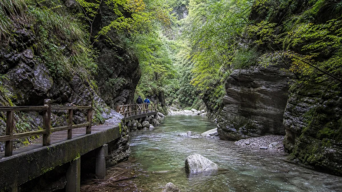
5A View location, maps and nearby scenic areasWhere the Jinsi Gorge walkway squeezes between stream and rock, stop without blocking the rail. The water may occupy only a thin channel, yet the walls erase the wider landscape. A few metres ahead, the path bends out of sight; below it, pale current slips from a shallow cascade into a dark pool.
This close scale is more useful than a record. Promotional descriptions sometimes compete over the “narrowest” or “deepest” canyon, but measurements change with route boundary, water level and the point chosen. Onsite, compare a person’s height with the wall, watch how little sky enters a slot, and listen to sound rebound from rock.
Treat the gorge as a line, not a plaza: decide which gate you will enter, which gate you expect to leave and how you will retrieve your vehicle or reach the final shuttle. Then choose one or two side sections. Water, closures and transport operation can change a complete traverse into an out-and-back walk.
Place the gorge in southeastern Qinling
Jinsi Gorge lies in Shangnan County, in the southeastern Qinling landscape of Shangluo. That location brings mountain forest, deeply cut tributary valleys and a climate influenced by both northern and southern air systems. It does not make every Qinling fact true at this one site.
The scenic area is commonly described through named sections such as Heilong, Qinglong and Bailong gorges, together with Shiyanzhai and connecting valleys. English spellings and the boundary of each section can vary. These names help navigation and carry cultural imagery; they are not geological categories.
The Jinsi Gorge 5A profile provides a map reference. The actual visitor experience extends along a branching, managed mountain corridor. Ticket gates, bus stops, car parks and a point labelled “scenic area” on a digital map may be far apart.
Before setting out, photograph the official route board. Mark your entry, intended exit, emergency points and any section currently closed. Mobile signal and online maps should support that plan, not replace it.
Read joints, layers and erosion without naming every wall “karst”
At close range, look for bedding, fractures, angular blocks and smoother water-worn surfaces. Park interpretation and regional geology may identify limestone or dolomitic carbonate rock in particular sections. In those rocks, dissolution can widen cracks and contribute to cavities, while stream incision and collapse shape the visible gorge.
That does not mean every cliff, hollow or pool has one karst origin. The Qinling–Daba region includes complex rock units, faults and uplift histories. A broad regional explanation should not be copied onto a wall whose lithology has not been identified. Use the sign at a specific geosite, and keep “appears,” “may” and “is interpreted as” when the evidence is visual rather than measured.
The narrow corridor also reflects structure. Water exploits weaknesses, but it does not cut a finished canyon in one dramatic event. Repeated runoff, sediment transport, freeze–thaw, root growth and slope failure continue to modify the route. Fresh debris after rain is not merely untidy scenery; it may be evidence of active instability.
Never collect rock, test a loose face or step beneath a taped-off overhang. Geology is easiest to read from the protected path, where several surfaces can be compared without adding damage.
Pools and waterfalls belong to a changing catchment
The stream links the gorge. Riffles aerate shallow water, constrictions quicken current, steps make cascades, and deeper pockets hold dark green or blue reflections. Each form depends on bed shape as well as discharge. A pool can look still while current moves beneath its surface.
Waterfall volume is seasonal and responds to recent rain. A cascade photographed as a white curtain may be a delicate thread during a dry spell. After storms, brown water, spray and powerful flow can replace clarity—and the safest route may close. Mist, rainbows and mirror-like pools are weather effects, not scheduled features.
The classical line “The highest good is like water; water benefits all things without contending” comes from the Daodejing, not from a poem written at Jinsi Gorge. Here it works better as an ethic than as decoration. Water sustains the forest and visitor experience, but it also carries soil, food waste, detergent and litter downstream.
Stay out of pools and channels even when no strong current is visible. Wading damages aquatic habitat, stirs sediment and can place a swimmer below a sudden release from upstream rain. Do not wash food or equipment in the stream, and carry every wrapper out.
Forest changes with moisture, slope and height
Near the channel, spray and shade favour mosses, ferns and moisture-loving plants. A few metres up a sunny wall, thinner soil and exposure create a different plant community. Along a longer ascent, elevation, aspect and human disturbance repeatedly change the balance of broadleaf trees, shrubs and other vegetation.
This is a vertical landscape, but not a perfectly stacked textbook of vegetation belts. Route elevation may be less important at one point than whether a slope faces sun, holds soil or receives waterfall spray. Look across the gorge for colour and canopy texture rather than assigning a zone from one leaf.
Southeastern Qinling supports substantial biodiversity, including birds, amphibians, insects and mammals. A species list is not a sighting forecast. Wild animals avoid busy walkways, move by season and may be active at dawn, dusk or night when visitor access differs. The name of a scenic feature is also not evidence that its animal namesake lives beside it.
Listen for bird calls and watch small changes: tadpoles where observation is allowed, insects over a quiet pool, leaf damage, seeds caught in moss. Never feed wildlife or play recorded calls. A quiet forest is habitat even when no large animal appears.
Dragon names and local stories are cultural maps
Names such as Black Dragon, Green Dragon and White Dragon turn separate gorge sections into memorable characters. Pools, rock forms and peaks may also carry stories told by guides or signs. These belong to local and scenic-area tradition unless a dated source is given; they should not be presented as documented events.
Tradition still has practical value. A name can preserve how residents distinguished dark water, pale rock, exposure or danger before modern coordinates. It can also change as tourism selects the most vivid version. Ask whether a story comes from a local household, a published gazetteer or a recent interpretation board.
Avoid forcing an unrelated celebrity onto the canyon. A famous poet need not have visited for a line about water or mountains to help reflection, and if a quotation was not written here, say so. The gorge has enough meaning in its measured surfaces, working stream and community memory.
Photography captions should follow the same rule. “Locally known as…” or “a guide tradition associates…” is more honest than turning a dragon pool into proof of ancient history.
Rangers, villages and tourism share one watershed
Forest rangers and maintenance crews monitor fire risk, unstable slopes, damaged railings and waste. After storms, reopening requires inspection, debris removal and judgement about water and rock. A closed section is a conservation and safety decision, not a service failure to bypass.
Nearby villages participate through accommodation, food, transport, guiding and seasonal work. Tourism can diversify income and fund infrastructure. It can also increase traffic, noise, water use, wastewater and pressure to build close to a sensitive corridor. “Pristine” is misleading when people actively manage both forest and visitor system.
Upstream activity affects every pool below. Toilets, kitchens and lodging need functioning waste systems; visitors should use designated facilities and avoid disposable picnic clutter. Report leaking bins or polluted runoff to staff rather than moving debris into the stream.
Respect private houses, orchards and service roads outside the managed path. Residents are not performers in a forest theme. Ask before close photographs and purchase local services without treating bargaining as a contest.
Plan the linear route around gates and transfers
The core route is linear. Current maps may present a lower entrance, an upper entrance, connecting scenic vehicles and several junctions. The easier direction depends on open paths, how much descent your knees tolerate, where your transport waits and whether the day’s vehicle connection is running.
A short plan explores the accessible lower gorge and returns before sustained climbs. A medium plan joins two main sections with a confirmed transfer. A full traverse can take most of a day once wet stairs, photo stops, crowd bottlenecks and the final shuttle are included. Do not use the fastest time in a promotional itinerary as your deadline.
Confirm ticket validity at both gates, the last boarding time and whether a shuttle carries you to a gate, car park or separate transfer hub. Keep screenshots or written names in Chinese for drivers. If service stops, know whether a legal walking return exists; do not improvise on a vehicle road or closed trail.
For a broader Qinling comparison, Mount Taibai compresses stronger elevation change into a mountain ascent, while Mount Hua foregrounds exposed granite ridges and engineered cliff paths. Hukou Waterfall is a different river-scale system whose flow should also never be promised from a calendar.
Wet steps, rockfall and height change set the safety rules
Spray, algae, rain and wet leaves make boardwalks and stone steps slick. Use shoes with reliable grip, keep one hand available for rails and slow down before turning for a photograph. Do not stand beneath drainage outlets or cliff faces during heavy rain.
Rockfall risk can rise after storms, freeze–thaw and slope work. Obey closures and staff instructions, move efficiently through signed exposure zones and never cross tape to test whether a path “looks fine.” Water levels can also rise from rain elsewhere in the catchment, beyond the sky you can see.
Keep young children within reach, especially beside railings, fast water and narrow passing points. The full route is not reliably suitable for strollers. Entrance plazas and selected viewpoints may be accessible, but steps, narrow boards, transfers and uneven gradients interrupt a step-free journey.
Visitors with mobility needs should ask which gate offers the longest currently step-free segment, where an accessible toilet is available and whether vehicles accept wheelchairs. A short water-level view is a valid gorge experience; the complete traverse is not a measure of courage.
Photograph from the path and leave the water unentered
Carry a lens cloth and a simple rain cover even under clear skies; waterfall spray reaches farther than expected. A fast shutter freezes droplets and reveals current shape, while a slower exposure can show flow only if you can hold the camera safely without a tripod blocking the path. Follow current tripod and drone rules.
Use people at a distance to show narrowness, but ask before making someone the subject. A polarising filter can reduce glare on pools, though removing every reflection may erase the cliff and canopy relationship. Protect the camera first; never step onto wet rock or into water for a lower angle.
Autumn colour, fog and powerful falls can transform the gorge, but none is guaranteed. Overcast light often handles wet rock and forest contrast better than harsh sun. If weather closes the upper route, photograph the lower stream carefully rather than treating caution as a failed trip.
At the exit, the gorge should feel larger despite its narrowness. Water connected rock, forest, villages, maintenance and your own pace. The most useful memory is not an unsupported record but a set of observed relationships: a fracture that guided flow, roots holding thin soil, a ranger’s closure protecting strangers, and clear water left undisturbed for the valley below.
The LoreLens app can help identify gorge sections and visible landforms while keeping local names, geologic interpretation and current route information separate.
Location profile
Where it is

Frequently asked questions
Is Jinsi Gorge a loop trail or a one-way traverse?
The core experience is a long, mostly linear gorge route with upper and lower access points, side sections and transport connections. The day's open paths and shuttle arrangement determine whether a through-walk is practical or you must return to the same gate. Confirm your exit and last transfer before entering.
How long does the full Jinsi Gorge route take?
A selective lower-gorge visit can take several hours, while a fuller traverse can occupy most of a day once stops, stairs and transfers are included. Published times vary with route boundaries, fitness, crowding and shuttle operation. Use the current map and leave a generous margin before the final service.
When are the waterfalls and autumn colours at their best?
There is no guaranteed date. Water volume responds to recent rain and catchment conditions, while leaf colour varies with temperature, elevation and aspect. Heavy rain can also close paths or increase rockfall and flood risk. Check recent official notices rather than travelling for one promised image.
Is Jinsi Gorge suitable for young children or wheelchair users?
Some entrance areas may be relatively level, but the main gorge includes wet steps, narrow boardwalks, uneven surfaces and sustained height change. It is not a reliably step-free route. Ask which short sections are currently accessible; keep children within reach and choose a lower viewpoint rather than forcing a full traverse.