Shaanxi · Baoji
Mount Taibai: Climb through the Qinling's Climate
Rise from forest valleys to wind-shaped shrubs, blockfields and alpine lakes on the Qinling's highest mountain, then decide whether a scenic-area visit or the demanding Baxiantai route fits your experience.
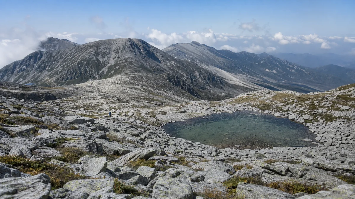
5A View location, maps and nearby scenic areasStart by looking upward through the trees. In Mount Taibai’s lower valleys, the mountain is green, enclosed and full of moving water. Higher up, trunks thin, shrubs lean away from wind, and broken rock replaces soil. Near the alpine zone, dark lakes can sit among blockfields while cloud crosses the ridge at walking speed. The mountain reveals height by changing what can live on it.
Mount Taibai (roughly “tie-bye”) is the highest mountain of the Qinling range. Its principal summit, Baxiantai (“bah-shyen-tie”), is commonly measured at about 3,767 metres above sea level. That number describes a summit, not the elevation every visitor reaches. A forest-valley day, a cableway-assisted high viewpoint and a long summit expedition are three different experiences with different risks.
Read the mountain vertically: first notice the forest community around you; then watch trees give way to low vegetation and exposed stone; finally distinguish a high tourist viewpoint from Baxiantai itself. The faster transport carries you upward, the more deliberately your body must catch up.
One ascent passes through several mountain worlds
Elevation reorganizes Taibai. Warm, moist lower slopes can support deciduous broadleaf forest and dense understory. Higher belts mix broadleaf and conifer species, then favor cold-tolerant conifers, shrubs and meadow-like openings. Near the top, wind, frost, thin soil and a short growing season leave mats of vegetation among bare rock.
These are not ruler-straight bands painted around the mountain. Slope direction, valley shelter, water, disturbance and local geology shift their boundaries. A north-facing hollow may hold cold conditions below a sunny ridge at the same elevation. Look for transitions rather than a single altitude assigned to every species.
The vertical sequence is one reason a cableway ride can feel startling. Leaves, temperature and cloud may change within minutes, while a hiker’s acclimatization does not accelerate with the cabin. At an upper station, pause before climbing more stairs. Notice the air, wind and your breathing before deciding whether to continue.
For a useful comparison, Jinsi Gorge reveals another Qinling ecosystem through a lower, deeply cut canyon. Taibai’s story is not that it has “more nature” because it is higher, but that elevation compresses several habitats into one climb.
Baxiantai is a summit, a watershed and an approximate number
Baxiantai’s elevation is often listed around 3,767 metres, with some references differing by a few metres. Survey technology, sea-level datum, the exact point measured and rounding can all produce small variation. The honest claim is that it is the Qinling’s highest peak; false precision adds little to a visitor looking at a broad summit crest.
The Qinling are a major mountain system built through a complex history of continental collision, faulting, uplift and erosion. Mount Taibai is not a lone volcanic cone and its summit rocks did not rise in one simple event. Rivers, frost and mass movement continue to reshape the relief after tectonics raised the range.
The range also separates major drainage systems. Water from Taibai’s northern slopes can enter tributaries of the Wei River and ultimately the Yellow River system; southern drainage feeds toward the Han River and Yangtze system. For the Guanzhong plain below, forested headwaters help regulate water, retain soil and supply communities, although no mountain can guarantee constant flow through drought and climate change.
The Qinling are often called a north–south climatic boundary of China. That is a regional pattern, not a wall where climate flips at one step. Monsoon, elevation, slope and longitude interact. Still, the contrast between the Guanzhong side and the Han River side helps explain why this ridge carries unusual ecological and cultural weight.
Forest life is present even when wildlife stays hidden
Taibai’s plant diversity reflects elevation and its position within the Qinling. Forests, shrublands, meadows, cliffs and stream corridors create different niches. Medicinal plants have long drawn local knowledge, but a species being “medicinal” does not make it safe to taste, legal to collect or abundant enough to harvest.
The Qinling takin, a large goat-antelope, occurs in the wider mountain forests and protected areas. It is powerful, mobile and generally best given great distance. Seeing one is never promised. If wildlife appears, do not approach, feed or block its route for a photograph; follow ranger instructions.
The crested ibis is part of the broader Qinling conservation story, especially in lower valleys, river plains and wet feeding habitat rather than on the exposed summit. Its recovery from extreme rarity is important, but listing it on a Taibai page must not imply that hikers should expect an ibis beside an alpine lake.
Wild animals often avoid busy trails. Tracks, calls, browsed plants and ranger signs may be more realistic evidence than a direct encounter. Protected-area rules, seasonal closures and no-entry zones give animals space to breed and move. A quiet mountain is not an empty mountain.
Stone seas and alpine lakes remember colder climates
Above the forest, Taibai’s blockfields, sometimes called “stone seas,” look like frozen waves of angular rock. Repeated freezing and thawing can split rock and move fragments downslope; gravity, water and long-term weathering also contribute. Avoid presenting every loose boulder as the product of one glacier.
Geomorphologists interpret cirque-like hollows, troughs, deposits and high basins around Taibai as evidence of Quaternary glacial and periglacial processes. The exact extent and phases of ancient ice have been studied and debated. What visitors see today are inherited landforms and active cold-climate weathering—not a large modern glacier flowing below the summit.
Alpine lakes such as Dayehai occupy high basins near the summit route. Their water level, ice cover and visibility change with precipitation, temperature and cloud. Names such as Dayehai, Eryehai and Sanyehai belong to local mountain geography; they do not imply identical size or easy public access.
Lake margins and thin alpine soils recover slowly after trampling. Stay on authorized paths and established durable surfaces, keep soap and food waste out of the water, and camp only where current rules permit. The stone landscape may look indestructible, but its small plants and wet ground are not.
Li Bai asked the mountain to open heaven’s gate
The Tang poet Li Bai wrote in Climbing Mount Taibai: “Taibai speaks with me and opens for me heaven’s gate.” In the poem, the mountain becomes a celestial companion; the speaker imagines riding the wind beyond the clouds and raising a hand close to the moon.
The verse follows a clear movement. A climber pushes westward and upward until ordinary geography seems to dissolve. The mountain answers, opening a passage into the sky; exhilaration then turns toward departure and the question of when the traveller will return. Height becomes freedom, but freedom carries separation.
This is poetry, not proof that Li Bai stood on today’s surveyed summit or that weather will open for a modern sunrise. Nor should the shared word bai, “white,” be turned into a claim that the mountain was named after the poet. “Taibai” also names the bright planet Venus in Chinese tradition and has associations with whiteness and snow; explanations of the mountain name have accumulated, and the place-name predates a simple poet-origin story.
The modern echo survives whenever hikers quote Li Bai above the clouds. The poem gives language to sudden altitude and distance, while modern forecasts, boundaries and rescue rules limit the fantasy responsibly. Lower the phone for a moment if cloud parts—the experience need not become a reenactment to carry the poem’s feeling.
Sacred mountain, medicinal knowledge and water source
Taibai has attracted Daoist practice, Buddhist presence, local mountain worship and pilgrimage in changing combinations. Temples, shrines, legends and place-names do not form one continuous institution, and individual structures have been rebuilt. The mountain’s sacredness came from remoteness, water, weather, medicinal resources and the sense that high ground approached another realm.
Local herbal knowledge is part of that history. The expression “Taibai medicines” and lists of special herbs can vary by community and source. Gatherers learned habitat and season, but modern conservation, property and health rules matter. Do not pick protected plants, buy unidentified wild material or self-medicate because a guide calls something ancient.
Mountain springs and forest catchments connect sacred value to daily life. Water leaving Taibai supports settlements, farms and ecosystems on both sides of the range. Rangers, water managers, village residents, trail workers and rescue teams therefore belong to the mountain’s story as much as hermits and poets.
For a different form of Shaanxi sacred geography, Famen Temple centers devotion in relic, monastery and ritual architecture. Taibai disperses it across elevation, weather and paths. Both are living cultural landscapes, not costume sets for visitors.
Choose among a valley day, a high viewpoint and Baxiantai
The first route is a lower scenic-area visit: use current internal transport and short walks to experience valleys, streams and forest without committing to extreme altitude. It suits mixed groups and uncertain weather, though steps, slopes and transfers can still limit accessibility.
The second is a cableway-assisted high visit. Buses and cableways can reach near or above the treeline, depending on which facilities operate. This gives rapid access to open views and alpine conditions, but the upper station is not Baxiantai. Wind, lightning, maintenance or ice can suspend service, and a fast ascent can provoke altitude symptoms.
The third is the Baxiantai long route. It involves sustained high-elevation walking, exposed terrain and, depending on the authorized route, overnight planning. Reservations, permits, guides, shelter availability, camping rules and seasonal access can change. Do not treat a line on an old hiking app as permission to cross a protected or closed area.
Choose before arrival, then keep a fallback. A summit goal should never force you past a closure, thunderstorm or sick companion. The sharp granite paths of Mount Hua create a different mountain challenge, but the same principle applies: transport infrastructure reduces some effort, not mountain exposure.
Altitude, temperature and lightning set the real timetable
Above 3,000 metres, reduced oxygen can cause headache, nausea, dizziness, poor sleep or unusual fatigue. Fitness does not guarantee immunity. Cableway users should ascend slowly after arrival, avoid immediate hard exertion and tell companions about symptoms. Worsening illness requires descent; confusion, breathlessness at rest or loss of coordination needs urgent help.
Temperature can fall sharply between the valley and upper ridge. Wind and wet clothing multiply heat loss, while ultraviolet exposure increases with altitude. Carry warm and waterproof layers, sun protection, food and water appropriate to the approved route even if the valley forecast looks mild.
Thunderstorms can form quickly in warm seasons. Exposed ridges, lone high points, metal railings and open water are poor places during lightning. Turn around before a storm reaches you; do not wait for a perfect photograph. Fog can erase path cues, and snow or ice can persist outside the period visitors casually call “winter.”
Check official route status, cableway notices and weather close to departure. Register or reserve where required, share your plan and turnaround time, and do not rely on a phone signal everywhere. Sunrise, cloud sea and a clear summit are possible experiences, never contractual ones.
Photograph the transitions and leave the alpine zone intact
The most revealing photographs compare belts: broad leaves against conifers, the last twisted shrubs below bare stone, or a small person crossing a blockfield. Wide views explain elevation; close views of frost-split rock and low plants explain survival. At lakes, photograph from durable paths rather than cutting across wet ground for a reflection.
Cold drains batteries, fog wets equipment and moving between warm cabins and cold air can fog lenses. Carry protection and spare power, but keep the pack light enough for safe balance. Drones and tripods may be restricted, and no image justifies blocking a narrow ridge or stepping outside a barrier.
Internal vehicles and cableways can improve access, but boarding gaps, stairs, steep paths, thin air and weather remain. Visitors needing step-free access should ask about the complete chain from ticket hall to an operating viewpoint, not merely whether a cableway exists. Baxiantai itself is not a barrier-free excursion.
Pack out waste, keep noise low, leave medicinal plants and rocks in place, and never feed wildlife. Alpine sanitation and water protection matter because decomposition is slow and streams connect the summit to communities below.
On the descent, watch the mountain rebuild itself in reverse: stone receives shrubs, shrubs give way to trees, and water gathers into louder channels. Baxiantai’s number marks a high point, but Taibai’s meaning lies in the transitions below it. The best visit is not the one that forces a summit; it is the one that returns with the mountain’s vertical order—and your companions—intact.
The LoreLens app can help identify vegetation belts, alpine landforms and cultural features, then connect them to Qinling ecology, poetry and mountain safety.
Location profile
Where it is

Frequently asked questions
How high is Mount Taibai, and is it the highest Qinling peak?
Baxiantai, Mount Taibai's principal summit, is commonly given as about 3,767 metres above sea level and is recognized as the highest peak of the Qinling range. Published figures can differ by a few metres because of survey methods, vertical datums and rounding. Treat 3,767 metres as a useful approximate elevation, not a universally identical reading.
Does a cableway go all the way to Baxiantai summit?
No. Scenic-area buses and cableways can remove much of the lower climb and reach high viewpoints, but they do not turn Baxiantai into a short walk from a summit station. The peak route remains a demanding high-mountain journey subject to protected-area rules, weather, seasonal closure, reservations and sometimes guide or overnight requirements.
Can visitors get altitude sickness on Mount Taibai?
Yes. Cableway-assisted ascent can bring visitors rapidly above 3,000 metres, where headache, nausea, dizziness or unusual fatigue may occur. Ascend conservatively, keep warm and hydrated, avoid pushing through worsening symptoms, and descend if needed. Seek staff or medical help for severe symptoms such as confusion, breathlessness at rest or loss of coordination.
What is the best season for hiking or sunrise at Mount Taibai?
There is no guaranteed season or sunrise. Snow, fog, rain, lightning, wind and closure can occur outside simple calendar labels, while cableways and high routes may suspend operation. Choose dates appropriate to your skills, check the official forecast and route notice shortly before travel, and carry a lower-level plan if the alpine zone is closed.