Xinjiang · Aksu
Tomur Peak: The Water Tower You Cannot Walk To
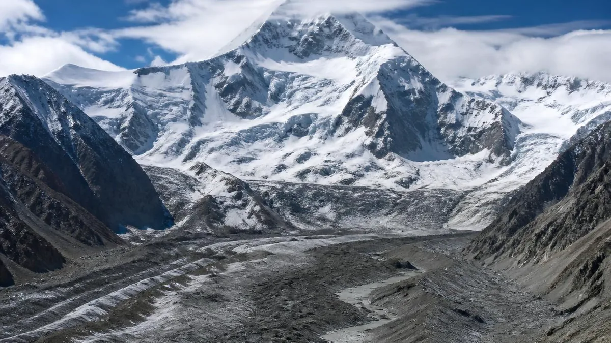
The highest summit in the Tianshan has at least three published heights, the range's largest concentration of ice, a canyon of red beds and salt domes at its foot, and a visitor route that stops a very long way short of the mountain.
5A View location, maps and nearby scenic areasThe Tianshan runs for some 2,500 kilometres, and its highest point stands at the far western end of the Chinese section, on the border with Kyrgyzstan. In Uyghur its name means iron. On the other side of the ridge it is called Victory Peak.
Almost nobody reading this will get near it. What you can reach is the country at its foot: a red-rock canyon with salt domes pushing up through the floor, a grassland village, a Kirghiz pasture. The peak stays out of sight up-valley.
That gap between the famous and the visitable is the honest subject here, because the mountain’s importance is not scenic. It is the largest concentration of ice in the Tianshan, and the reason a chain of oases exists downstream.
Three heights, three names, one summit
Start with the number, because there is no single correct one.
Chinese sources today give 7,443.8 metres. The Chinese national surveying bureau, which formally applied the name Tomur to the range’s high point in 1977, measured the main summit that year at 7,435.35 metres and a west summit at 7,435.29; the older figure still circulates in nature-reserve material. Across the border the mountain is Jengish Chokusu in Kyrgyz and Pik Pobedy in Russian, both meaning Victory Peak, and is normally listed at 7,439 metres, from a Soviet survey of 1943.
The spread is not sloppiness. Different years, different sides, different instruments, and in one case a different summit. Give a height with its source.
Two other facts are worth carrying. This is generally treated as the world’s most northerly 7,000-metre peak, and nothing further north on Earth stands higher—Khan Tengri, 16 kilometres away, only reaches that height if you count its ice cap. And the top is not a dome: descriptions give a fish-spine crest running east to west for about 800 metres, roughly a metre wide.
What the World Heritage listing actually covers
Xinjiang Tianshan was inscribed in 2013 under criteria (vii) and (ix), as a serial property with four components: Tomur in Wensu County, Aksu; Kalajun-Kuerdening in Tekes and Gongliu; Bayinbuluke in Hejing; and Bogda around Fukang. The total is 606,833 hectares inscribed plus 491,103 hectares of buffer.
Tomur is the largest of the four: it holds the range’s highest summit, another fifteen peaks above 6,000 metres, and a vegetation sequence running from the ice down towards the edge of the Taklamakan.
Now the boundary question, which brochures skip. Chinese planning documents give the Tomur component as 3,448.28 square kilometres with a 2,801.20 square kilometre buffer, and describe it as covering most of the Tomur Peak National Nature Reserve, part of the Tomur Grand Canyon landscape area, and all of the Wensu salt-dome national geopark. The 5A scenic area is a different boundary—752 square kilometres, assembled in late 2021 from the canyon, Taghlak village and Bozidun, and awarded 5A in December 2024.
So unlike the similarly named canyon south of Ürümqi, which lies wholly outside the property, this one genuinely overlaps it. But overlapping is not being it. The property is described as having no permanent residents and no extractive industry; Bozidun is a working township. And the reserve runs its own zoning—core 2,167, buffer 865, experimental 772 square kilometres—a third system again.
The largest ice centre in the range
The ice here is the headline fact, and it comes in two accounting frames that are often mixed.
Counts give 829 glaciers in the Tomur massif with a combined area near 3,849.5 square kilometres, of which about two-thirds lies in China; the China-only figures are 509 glaciers and roughly 2,746 square kilometres. Either way this is about a quarter of all glacier area in the Tianshan.
The individual glaciers are large. The Khan Tengri glacier, straddling the China–Kyrgyzstan border, runs 60.8 kilometres and is routinely listed among the world’s longest valley glaciers. The Tomur glacier itself is about 32 kilometres, and over twenty glaciers here exceed ten.
The form matters more than the ranking. Most of this ice—some 85 percent by one account—is dendritic valley glacier, tributary streams of ice joining a trunk, a type Chinese glaciology named after this massif. Chinese sources describe the Tomur–Khan Tengri knot as one of the world’s three great concentrations of mountain glaciers, a claim you will see promoted as third place; treat the ordering as marketing and the concentration as real.
Why the ice is a water tower
This is the section that changes how the canyon reads.
Down here the climate is arid; up there, annual precipitation reaches 400 to 600 millimetres and above 800 on the highest ground, and much of it never leaves as rain. It leaves as meltwater, on a schedule set by summer temperature rather than storms.
The numbers are stark. The Muzart river, fed by the Muzart glacier, is described as 81 percent glacier-fed—among the highest proportions of any river in China; the Taylan is put near 64 percent. On the Koxkar glacier, isotope work on summer flood samples apportioned 74.8 percent of flow to glacier melt against 25.2 percent to precipitation.
Follow that water and you get the oases. The Aksu river forms in Wensu County where the Kumarik and Toshkan rivers meet, carries roughly 8.06 billion cubic metres a year with glacier and snowmelt supplying somewhere between 36 and 71 percent depending on the study, and provides about 74 percent of the water in the Tarim main stem. It is the only one of the Tarim’s source rivers with year-round surface flow. The Muzart feeds a different system, the Weigan, and the oases around Kuqa.
Then the argument that makes “water tower” more than a metaphor. High-altitude temperature and precipitation vary little from year to year, so rivers with a large glacier share have unusually steady annual flow. That stability, not abundance, is what allows irrigated agriculture in a desert—and why the Tarim source basins, with over 7,300 glaciers across some 13,100 square kilometres, matter to people who will never see them.
What the ice is actually doing
Here the sources fight, and pretending otherwise would be dishonest.
The long-run direction is clear. From the seventeenth-century maximum to the 1980s, glaciers in this massif are described as retreating 0.8 to 4.3 kilometres, with the rate easing afterwards. The best-monitored glacier here, Qingbingtan No. 72, lost about 1.53 square kilometres between 1964 and 2009 while its terminus retreated 1,852 metres—one accounting puts the area loss near 24 percent. During observation it melted at three to five centimetres a day, and its surface moved at about 47 metres a year, fast enough that the ice keeps feeding its own snout and slowing the retreat. Compare the reference glacier at the head of the Ürümqi river, which lost around 14 percent of its area since 1959 and retreated under 140 metres.
Against that sit inventory figures showing glacier area increasing in the reserve—more than 61 square kilometres between 1997 and 2007 and nearly 69 between 2007 and 2017. Those cannot be reconciled with the terminus records by picking a favourite; they reflect different sources, methods and boundaries, and debris-covered ice is notoriously hard to delimit. The IUCN’s 2025 outlook, range-wide, reports Tianshan glaciers retreating at an average 1.48 percent a year over 35 years, with the sharpest losses since 2020.
Seven belts from desert to permanent snow
The reserve is described as holding the most complete vertical sequence on the southern flank of the Tianshan, and the list is worth having on the drive in.
From the bottom: warm-temperate desert on the alluvial fans at roughly 1,450 to 1,900 metres; temperate desert-steppe above it; montane steppe, where feather grass takes over; subalpine meadow with patches of Schrenk spruce around 2,600 to 2,900 metres; alpine meadow from about 2,900 to 3,900, the reserve’s core; alpine cushion vegetation to around 4,500; and permanent snow and ice above.
Two details reward attention. The snow line sits at about 3,600 metres on the northern slopes and 4,200 on the southern—the sunnier side pushes its ice higher, which is why the south flank is the arid one. And the spruce here behaves differently from the famous shaded-slope forests of the northern Tianshan: on this flank it survives in small patches, on sunny or gently graded ground as well as half-shaded slopes, dense where it holds and absent for kilometres where it does not.
Species lists are long: 1,218 vascular plants in 83 families, plus 180 macrofungi and 120 lichens, with roughly 80 percent of the fungi under spruce. This is important snow leopard country. You will not see one.
Red beds and salt: what the canyon shows
The canyon you actually visit is a separate geological story from the peak above it.
Tomur Grand Canyon, also called Kuduluk—Uyghur for something like perilous or mysterious—runs about 25 kilometres east to west and 20 north to south, comprising three main valleys, twelve branch valleys and hundreds of minor ones. The rock is Cretaceous lake sediment, red beds laid down in still water, lifted as the Tianshan rose and then cut by water and ice. That is why the walls are red and horizontally banded rather than crystalline.
The unusual part is underneath. Buried rock salt is less dense than the sediment above it and, being ductile under pressure, rises through it in slow plumes. Chinese descriptions record 36 giant salt domes here, gourd-shaped diapirs in the Aoqike area, with salt karst developed on them—dissolution features of the sort limestone usually provides, in a rock that dissolves far faster. It is called China’s largest rock-salt karst landscape, and the whole salt-dome geopark falls inside the World Heritage boundary.
Look for two things: bedding that reads as ruled lines across a wall, and places where those lines are arched or broken upward. The arching is the salt moving.
Where you can go, and where you cannot
Be blunt, because the scenic area’s name promises a mountain it does not deliver.
The 5A area has three parts. The canyon is the geological centrepiece. Taghlak village, at about 2,200 metres, is mountain steppe, flowering roughly May to September. Bozidun, a Kirghiz township spanning 1,500 to 3,500 metres, supplies pasture, the Akbulak grassland and performances of the Manas epic.
Inside the canyon you travel in the operator’s converted off-road shuttles, because the route runs on river-bed sand. They stop at a subset of the numbered valleys—commonly 3, 4 and 6, with 1, 2 and 5 not served. A standard half-day is: shuttle to valley 4, walk the boardwalk through to valley 3 in about ninety minutes, shuttle out from 6. Sections close without notice, toilets are scarce, and flash flooding is a real hazard rather than a legal disclaimer.
What you cannot do is go up. The core of the nature reserve is closed to non-scientific activity, the summit sits on an international border, and China’s mountaineering rules require approval for any peak above 3,500 metres, with only listed peaks open at all. The old approach put base camp at the snout of the Qiongtailan glacier near 3,700 metres, days beyond any road.
One more thing about the emptiness. During the World Heritage nomination, Wensu County relocated 300 herding households and more than 40,000 animals out of the Tomur area, and from 2014 herders inside the reserve began moving out; Taghlak and neighbouring villages turned to tourism. The pasture you are looking at was recently emptied on purpose.
Why nobody sells you a summit
The climbing record explains the silence, and it is a grim one.
A Soviet expedition claimed the high summit in September 1938, but their measurement of about 6,900 metres clashed with the 1943 survey’s 7,439, and the claim was widely doubted even as the official line upheld it. A 1955 attempt ended with eleven of twelve members dying in a blizzard. The verified first ascent came in 1956, when a party led by Vitaly Abalakov put eleven climbers on top—among them Ural Usenov, the sole survivor of the previous year.
China came up the other side. In early 1977, after a request signed jointly by the sports commission, the PLA general staff, the Academy of Sciences and the surveying bureau and cleared at Politburo level, a 261-person expedition went in. Summits followed on 25 July, eleven climbers, and 30 July, seventeen more—28 in total by most accounts, 27 by some—by the southern slope and southeast ridge. The expedition’s own book presented the climb as a first ascent, which it was not; it was the first from China.
A Japanese women’s team was hit by three avalanches in two days in 1986, later attempts failed with fatalities, and the first winter ascent waited until February 1990. More than eighty climbers are reported to have died here. Weather windows are five or six days at best.
Look up-valley before the shuttle turns round
At the far end of the walkable canyon, find a spot where the valley opens north and stand still.
You will probably not see the summit. What you can see is the direction the water comes from, and the water is the argument. Somewhere up there, several hundred cubic kilometres of ice sits on rock that gets 400 to 600 millimetres of precipitation a year while the ground under your boots gets a fraction of that. Every summer a thin skin of it turns to river, on a schedule regular enough that people far downstream have planted permanent orchards on the assumption it will happen again.
The red walls beside you were a lake bed once, and the salt pushing up through them is older still. But the thing that makes this place matter is not visible from the boardwalk, is closed to visitors, and is retreating. That is an odd summary for a 5A scenic area, and it is the accurate one.
The LoreLens app can help you identify red-bed sequences, salt-karst features and alpine vegetation belts while explaining the geology around them.
Location profile
Where it is

Frequently asked questions
How high is Tomur Peak, and is it in China or Kyrgyzstan?
Both, and the height depends on which survey you follow. The summit sits on the China–Kyrgyzstan border, in Wensu County on the Chinese side, and it is Kyrgyzstan's highest point as well as the highest point of the Tianshan. Chinese sources today give 7,443.8 metres. The Chinese national survey in 1977 measured the main summit at 7,435.35 metres and the west summit at 7,435.29, and that older figure still appears in nature-reserve material. On the Kyrgyz and Russian side the mountain is Jengish Chokusu or Pik Pobedy, both meaning Victory Peak, and is normally listed at 7,439 metres, a figure from a 1943 Soviet survey. Quote a number with its source attached rather than picking one.
Is the Tianshan Tomur scenic area part of the World Heritage site?
Partly, and this is worth getting right. Xinjiang Tianshan was inscribed in 2013 as a serial property with four components—Tomur in Wensu County, Kalajun-Kuerdening in Tekes and Gongliu, Bayinbuluke in Hejing, and Bogda around Fukang—totalling 606,833 hectares plus 491,103 hectares of buffer. Tomur is the largest component, given as 3,448.28 square kilometres with a 2,801.20 square kilometre buffer, and Chinese planning documents describe it as covering most of the Tomur Peak National Nature Reserve, part of the Tomur Grand Canyon landscape area and all of the Wensu salt-dome national geopark. The 5A scenic area is a separate 752 square kilometre tourism boundary covering the canyon, Taghlak village and Bozidun. The two overlap in the canyon; they are not the same line, and the property itself is described as having no permanent residents and no extractive industry.
Can visitors see or reach Tomur Peak itself?
No. The scenic area sits on the southern approaches, and the developed ground is canyon floor, grassland village and pasture rather than high mountain. The summit is a 7,000-metre glaciated peak on an international border inside a national nature reserve whose core zone is closed to non-scientific activity; climbing anywhere above 3,500 metres in China requires official approval, and only peaks on a published open list may be attempted at all. Historic expeditions placed base camp at the snout of the Qiongtailan glacier, days of walking beyond any road. Treat the peak as the reason the landscape works, not as a destination.
When should I go, and how do I get around inside?
May to October is the practical window for the canyon and the grassland; the village area is described as flowering from May to September and turning to snow scenery after November. Aksu is about an hour and a half away by road. Inside the canyon you move by the operator's converted off-road shuttles, which run on the river-bed sand and stop at a subset of the numbered valleys—commonly 3, 4 and 6. Self-drive access is restricted: as of June 2025 the entry fee was restored to 200 yuan per vehicle with 48-hour validity, a daily cap of 300 vehicles, and a four-wheel-drive requirement with ground clearance above 23 centimetres. Ticket prices, shuttle routes, opening hours and which valleys are open all change—confirm at the gate, and take flood and closure warnings seriously.
Sources and further reading
Background references for the history and place names in this guide. Opening hours, ticketing and access change often — always confirm with official local information before travelling.