Anhui · Lu'an and Jinzhai
Tiantangzhai: Follow Water to the Dabie Divide
Walk from waterfall spray and mixed forest to the high divide at Anhui's Jinzhai Tiantangzhai, with clear route choices, layered local history and no promises about clouds, water or cross-border access.
5A View location, maps and nearby scenic areasPause before the first named waterfall and listen. The loudest water is not always the fall in front of you: one note may come from the drop, another from a channel hidden under leaves, and a third from runoff crossing the steps behind you. That layered sound is the quickest introduction to Tiantangzhai. Water, forest and ridge are one system here, not three attractions assembled for a brochure.
This guide is specifically for the 5A-rated Tiantangzhai tourist area in Jinzhai County, Lu’an, Anhui. The mountain continues toward Luotian County in Hubei, where another operator uses the same scenic-area name. The landscape is adjacent; admissions, gates and visitor rules are not automatically shared.
Choose a day by terrain, not by a checklist. A water-first visit combines the signed waterfall group with a manageable forest or canyon section. A ridge-first visit uses any operating shuttle or cableway to conserve energy, then adds only the high trail that weather and closures allow. Photograph the current map and return notices before setting off.
Two Tiantangzhai attractions meet one mountain landscape
Tiantangzhai lies in the Dabie Mountains, near the Anhui–Hubei boundary. A ridge can be continuous in ecological and geological terms while being divided administratively. On a broad map, paths on both sides may appear almost connected. On the ground, a closed gate, protected zone, provincial line or different transport system can make that apparent shortcut unusable.
The distinction matters from the moment you book. Search results may omit “Anhui,” while hotel and driver listings may use Tiantangzhai for a town, a mountain, a park or either scenic operation. Confirm Anhui Province, Jinzhai County, the exact entrance and the return arrangement. A ticket bought from one operator should never be assumed valid with the other, and a ridge marker is not permission to cross a controlled boundary.
The 5A grade belongs to the managed Anhui tourist area, not to every slope visible from it. National-forest-park, protected-area, village and tourist-operation boundaries may also differ. Those labels describe different responsibilities; they should not be compressed into one imaginary fence.
Read the watershed before chasing the highest point
The main Dabie ridge forms a major regional divide between the Huai River and Yangtze River drainage systems. In simple terms, water leaving the Anhui side generally feeds valleys toward the Huai system, while water on the southern side runs toward Yangtze tributaries. A raindrop does not follow a tourism map: slope, side valley and local channel determine its actual course.
Many descriptions give the main Tiantangzhai summit an elevation of about 1,729 metres, sometimes printed to the centimetre. For a visitor guide, about 1,730 metres above sea level is the honest scale unless you are reading a surveyed marker. Published figures may refer to a named summit, a control point or the highest ground within a stated boundary. Reaching a cableway station or ridge viewpoint does not necessarily mean standing on that exact point.
Look sideways as well as up. The useful scale is the depth between stream and skyline: water cuts down, forest climbs the slopes, and the ridge catches cloud and wind. On a clear day the divide is legible as a long edge rather than a single triumphant peak. In mist, nearby vegetation and the direction of flowing water may explain the mountain better than a missing panorama.
Waterfall volume follows weather, not the photograph on the ticket
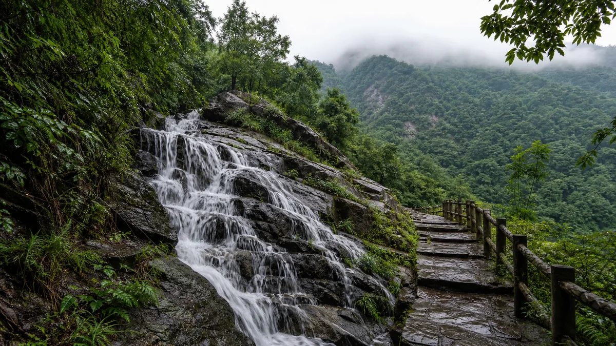
The Anhui attraction is known for a sequence of named waterfalls and pools reached along steep, forested watercourses. Their visible height is only one part of the story. Bedrock steps break the stream, narrow channels accelerate it, and tree cover keeps much of the catchment shaded. Stand where barriers allow and compare smooth sheets, broken spray and water that disappears behind rock before rejoining below.
Promotional sources count waterfalls differently. Some count only large named drops; others include seasonal cascades or smaller steps inside a “waterfall group.” A precise total therefore says less than the conditions on your day. Flow often rises after rain and falls during dry spells. A thin ribbon is still a hydrological clue, while a dramatic torrent may arrive with closures and danger.
Never step onto wet rock to reproduce a long-exposure image. Polished stone, algae and leaf film can be slick even when a handrail looks dry. Sustained or intense rain can send runoff through side gullies and raise streams quickly. If staff close a lower platform or canyon segment, move to an open forest route; a paid ticket is not a claim on a particular volume of water.
The forest is a vertical community and a place of work
Tiantangzhai sits in a climatic transition within central China. Changes in elevation, aspect, moisture and past disturbance support a varied mountain forest in which deciduous and evergreen broad-leaved plants can overlap. Do not expect a botanical border at one step. Instead, watch leaf shapes, bark, vines, ferns and the density of the understory change gradually between a damp valley and an exposed upper slope.
Claims about “forest coverage” vary with survey date and which boundary is measured, so a single percentage can create false precision. More revealing signs are structural: several canopy heights, fallen wood decomposing in place, young growth inside a closure, and a stream bank held by roots. A planted stand, recovering slope and older mixed patch may all look equally green in a wide photograph while functioning differently.
This is also a working landscape. Residents have farmed, carried goods, repaired paths and hosted travellers in the Dabie highlands; today cleaners, drivers, cableway technicians, food sellers, guides and forest rangers make a visit possible. Keep music low, take litter back to a bin, do not pick fungi or flowers, and never feed wildlife. Conservation is labour, not an atmosphere that appears by itself.
“Tiantangzhai” is a name with stories, not a dated certificate
The Chinese name can be read as “Heavenly Stronghold.” Local histories and tourist accounts offer different earlier names—often forms of Duoyunshan or Duoyunzhai, “many-cloud mountain/stockade”—and connect the heights with refuge, fortification or uprisings in different periods. Versions disagree over leaders, dates and which surviving stones belong to which episode. Treat them as attributed traditions unless an onsite label supplies a documented source.
The terrain explains why such stories gather here. A high ridge overlooks approaches; narrow valleys can be defended; cloud and forest hide movement; and routes through the Dabie Mountains have repeatedly mattered to soldiers, traders and communities. That plausibility does not turn every wall base into an ancient fort. Rebuilding, forestry, farming and tourism can move or reuse stone.
The Dabie region also carries a powerful twentieth-century revolutionary history. Read a dated memorial or local museum for the people, units and events it actually documents, but do not make every waterfall a battle backdrop. Residents continued to cultivate land, raise families, protect forest and build visitor services through and after political violence. The mountain’s human history is wider than war, just as its name is wider than one legend.
A line from Mencius travels responsibly into the forest
An old Chinese line offers a useful question here: “If axes enter the hills and forests only at the proper seasons, there will be more timber than can be used.” It comes from Mencius, in a passage where the Warring States thinker urges King Hui of Liang to govern resources and livelihoods with restraint. It was not written about Tiantangzhai, and it does not identify a ruin or prove the age of a path.
The story has a clear turn. Mencius begins with ordinary needs—food, fish and timber—then argues that abundance disappears when harvest ignores seasons. Good government is measured not by a magnificent claim but by whether households and landscapes can renew. The consequence is social as well as ecological: timed use supports people rather than treating forest as an infinite store.
Carry that line on the signed forest section of the waterfall route or the Baima Grand Canyon boardwalk, where it functions as an interpretive lens, not a site quotation. Regeneration fences, fire controls, ranger instructions and temporary closures are its modern echo. So are the workers who balance village livelihoods with visitor pressure. Staying on the path is a small participation in that continuing story.
Choose either a water day or a ridge day before combining them
For a water-first route, begin with the waterfall group while your footing and attention are fresh. Add an open lower forest or Baima Grand Canyon section only after checking whether it returns to your entrance or finishes near transport. This option keeps you close to water and vegetation, though it still involves wet steps, gradients and possible one-way controls.
For a ridge-first route, use the Anhui operator’s scenic shuttle and cableway only if they are running, then walk the signed high section allowed that day. Mechanical transport saves elevation; it does not make the ridge level or guarantee access to the main summit. Cloud may remove the long view, while wind or thunder can stop the cableway and close exposed trail.
A combined long day makes sense only with an early start, stable conditions and a firm return plan. Check the last downhill ride, walking alternative and which gate the route reaches. Never build the itinerary around crossing into the Hubei operation unless both sides currently and explicitly confirm a legal through-route. If information conflicts, return within Anhui by the route staff identify.
Wet stone, thunderstorms and access limits should change the plan
Wear shoes chosen for slick gradients, not for a paved city park. Keep one hand free on stairs, store the phone before difficult descents and give way at narrow viewing platforms. In heavy rain, leave streams and confined gullies early. A mountain shower can become a flash-flood problem downstream even when the sky above you is briefly bright.
On the ridge, thunder is the decisive warning. Descend from exposed high ground, metal railings and isolated trees according to staff direction; do not wait for the photograph after the first rumble. Wind, low cloud, ice, heat, fire controls and maintenance can also change access. Screenshot or photograph dated notices because old route blogs often outlive the conditions they describe.
Scenic transport does not make Tiantangzhai step-free. Boarding can involve gaps or high steps, and upper stations still connect to stairs, rough paving and steep paths. Visitors using wheels, canes or limited-energy pacing should ask the visitor centre which same-day route has the fewest steps, where an accessible vehicle can stop, whether toilets are usable and how an early return works. A shorter waterfall viewpoint can be a complete visit.
Photograph relationships, then leave the mountain connected
For waterfalls, include a tree trunk, bridge or safely positioned person to show scale. A moderately slow shutter can reveal flow, but brace from a legal platform and keep straps clear of passers-by. In forest, expose for bark and leaves rather than a white sky. On the ridge, use cloud as depth; a “sea of clouds” is a weather event, not an item included in admission.
Follow current rules for drones, tripods and restricted zones. Do not cross a rail for an uncluttered foreground, stack stones, enter pools or widen a social trail. Quiet movement improves the chance of hearing birds and also respects other walkers. The most truthful final frame may be water disappearing under the canopy rather than a summit hidden in mist.
Use the Tiantangzhai 5A scenic-area profile for the Anhui map point and coordinates, then rely on the current Jinzhai operator map for gates, tickets and open trail. Continue to Mount Langya for a lower Anhui mountain shaped by literature and city life, Jigong Mountain for forest and modern resort history, or Wugong Mountain to compare a more exposed high-ridge walking landscape.
Location profile
Where it is

Frequently asked questions
Is this guide for the Anhui or Hubei Tiantangzhai?
It covers the nationally rated 5A tourist area in Jinzhai County, Lu'an, Anhui. Luotian County in Hubei operates a neighbouring attraction with the same Tiantangzhai name. Check the province, entrance and operator on every ticket, map and transport booking.
Can I cross from Anhui Tiantangzhai into the Hubei attraction?
Do not plan on a through-route. A provincial boundary and connected mountain terrain do not guarantee that a visitor trail, checkpoint or ticket connection is open. Ask both operators about current access, and arrange your return from the entrance named on your booking.
Do I need the cableway to visit Tiantangzhai?
Not necessarily. A waterfall or lower-valley visit can be rewarding without a high ridge, while a working cableway can reduce some climbing on a summit-oriented day. It does not remove stairs or rough trail, and operation can change with wind, storms, maintenance and demand.
When are the waterfalls and sea of clouds best?
Waterfalls often carry more water after sustained rain, while cloud layers depend on rapidly changing temperature, wind and humidity. Neither is guaranteed, and heavy rain can close trails or create flash-flood danger. Choose a safe route from the day's conditions rather than chasing a forecast image.