Hubei · Yangtze River
Three Gorges Dam: How to Read the Wall Across the Yangtze
Stand above the world's largest hydropower station and read more than its record-breaking scale: a century of ambition, flood control, ship lifts, submerged towns and 1.3 million changed lives.
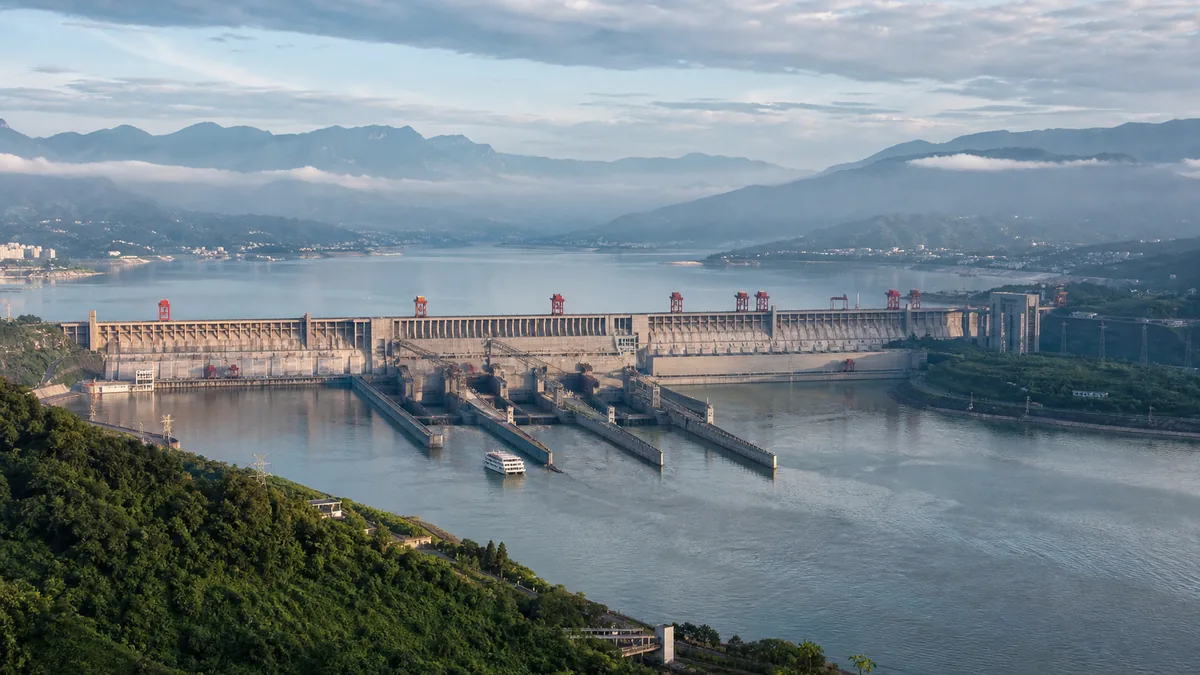
5A View location, maps and nearby scenic areasFrom Tanziling, the Three Gorges Dam does not first look like a wall. It looks like a system: concrete sections crossing the Yangtze, parallel ship locks cut into the bank, transmission lines leaving the powerhouses and a reservoir disappearing west towards the gorges.
That is the best way to begin reading it. The Three Gorges Dam is not only a record-sized object. It is flood infrastructure, a power station, a shipping route, a remade landscape and a decision that altered the lives of roughly 1.3 million relocated people. Stand still long enough for all those layers to occupy the same view.
Look in this order: find the upstream and downstream water levels, trace the ship locks like a staircase, locate the powerhouses beside the dam, then turn towards the reservoir. The engineering becomes clearer once you follow what water, ships and electricity are each being asked to do.
The scale in front of you
- Dam length: 2,335 metres, or about 1.45 miles, across the river valley.
- Height: the crest elevation is 185 metres above sea level; maximum structural height is about 181 metres.
- Power: 34 turbine-generator units with 22,500 megawatts of installed capacity—the world’s largest hydropower station by this measure.
- Reservoir: at the normal pool level of 175 metres, the reservoir extends for roughly 600 kilometres upstream towards Chongqing.
- Location: Sandouping, Yiling District, Yichang, Hubei, around 40 kilometres upstream of central Yichang. The 5A scenic-area profile shows its map and coordinates.
The numbers are enormous, but keep unlike measurements separate. A crest elevation is not exactly the same thing as a wall’s visible height. Installed capacity is not the same as electricity generated every year. Reservoir length also changes with water level and with the boundary someone chooses to measure.
That distinction is useful here: the dam is impressive enough without turning every statistic into a superlative.
From Sun Yat-sen’s plan to Mao’s “smooth lake”
In 1919, Sun Yat-sen proposed using the Three Gorges’ water power in his plans for China’s industrial development. It was an idea before the country possessed the finance, technology or political stability to build it.
Foreign and Chinese engineers later surveyed possible sites. War, revolution, competing designs and arguments over cost delayed any final commitment. In 1956, after swimming in the Yangtze, Mao Zedong wrote of “a smooth lake rising in the high gorges.” The poetic image became inseparable from the project, but poetry did not settle its engineering, economic or human questions.
Formal approval came only after decades of study and unusually visible debate. Construction began in 1994. The river was closed and diverted in stages; the first generating units entered service in 2003; and the final underground unit came online in 2012.
The dates matter because they replace a simple story of one leader’s command with something more accurate: a proposal argued over across governments and generations, then built in stages while the river continued flowing through the worksite.
The human map beneath the reservoir
The project’s heaviest number is not measured in concrete. Reservoir filling required the relocation of about 1.3 million people across Hubei and Chongqing. Residents moved to newly built neighbourhoods higher on the slopes, to other counties, and in some cases to distant provinces.
“Relocation” can sound like a line on a planning document. On the ground it meant leaving houses, fields, family graves, local networks and familiar river access. New apartments and roads could improve services for some families; land, work and community ties were harder to reproduce. Experiences varied, and a single verdict cannot speak for every household.
Cities including old Wanzhou and Fengjie rebuilt substantial districts above the new waterline. Archaeologists conducted rescue excavations before inundation, and selected monuments were moved or protected. Yet thousands of known sites and the everyday landscapes between them could not all be saved.
On a cruise, the broad, calm water can therefore be misleading. You are not passing through an untouched lake. Roads, settlements and cultivated valleys once occupied lower elevations beneath or beside the present shoreline. Look for new towns stepping up the slopes: they are part of the dam as surely as the concrete wall.
Why build it: three benefits, none without a footnote
Flood control was the strongest public argument. The Yangtze’s floods repeatedly devastated the middle and lower basin; the disasters of 1931 and 1954, and the major flood of 1998, remain central to the project’s memory. The reservoir can hold part of a flood surge and operators can adjust releases to reduce pressure downstream. It cannot abolish floods: rainfall below the dam, reservoir conditions and the timing of tributary flows still matter.
Electricity is the second purpose. Water passing through the turbines provides large quantities of low-carbon power without burning coal at the station. Output varies from year to year with hydrology and operational priorities. Hydropower avoids many air emissions, but “renewable” does not mean impact-free: creating the reservoir required land, materials and ecological disruption.
Navigation is the third. The higher, deeper channel removed many historic rapids and allowed much larger vessels to reach inland ports. Freight capacity rose and journeys became more predictable. This commercial corridor is one of the clearest ways the project connected Chongqing more closely to the lower Yangtze.
Each gain changes the river in return. Researchers and agencies continue to study sediment trapped by the reservoir, erosion downstream, water quality, landslide risk and effects on fish and other species. Some impacts have multiple causes, including other dams and development across the basin, so it is as unhelpful to blame the Three Gorges Dam for every change as it is to pretend the changes do not exist.
Five locks and one elevator for ships
Now look towards the riverbank and find the most legible part of the machinery: two parallel flights of five-stage ship locks. A vessel enters a chamber, gates close, and the water level rises or falls. Repeating the process lets large cargo and passenger ships climb the difference between the upstream reservoir and downstream river.
The locks trade speed for capacity. A full passage can take several hours, with the precise time depending on traffic, scheduling and water levels. From above, the chambers resemble an oversized staircase; from a vessel, each lock becomes a temporary concrete room whose waterline moves against the wall.
The ship lift, in regular service since 2016, solves the same problem differently. It carries a vessel of up to about 3,000 tonnes inside a water-filled chamber, moving it vertically by as much as roughly 113 metres. The lift itself takes much less time than the five locks, although queuing and operating conditions affect the full transit.
Cruise itineraries do not guarantee passage through either system. Some ships berth on one side of the dam and transfer passengers by road; security, maintenance, river conditions and scheduling can all alter the plan. Treat lock or lift transit as a possible experience, not a promised attraction unless your operator explicitly confirms it.
A practical viewing sequence
The classic land visit begins with controlled tourist transport and one or more observation areas. Tanziling, the ridge viewpoint, is usually the best place to understand the whole plan: dam, locks, upstream reservoir and downstream channel. A model or diagram, when available, helps you identify components before looking back at the real structure.
Then move to a lower or more frontal viewpoint if the current route permits it. Distance makes the wall look flat; a lower angle restores its mass. If spillways are releasing water, watch from the designated area and expect intense noise and spray. Release displays are operational events, not scheduled performances.
Allow time for security checks and internal transfers. The dam is critical infrastructure, so visitor zones and photography restrictions deserve more attention than at an ordinary scenic site. Carry your original passport, follow posted signs, and confirm the latest admission procedure with a cruise company, hotel or authorised tour operator before departure. Opening routes can change without the dam itself being “closed.”
From Yichang, the site is commonly visited as a half- or full-day organised excursion. On a Yangtze cruise, read the exact wording of the itinerary: “Three Gorges Dam visit,” “ship-lock passage” and “ship-lift experience” describe different things.
How to photograph an object this large
At Tanziling, use people, buses or lock gates for scale; an empty panorama can make two kilometres of engineering look surprisingly small. A moderate telephoto lens is useful for turbines, cranes and vessels inside the locks, while a wide lens can show the relationship between river and infrastructure.
Photograph the difference, not only the dam: high and low water, old valley and new reservoir, cargo vessel and concrete chamber, power lines and distant mountains. Midday haze is common, and rain may obscure the full span. These conditions are not wasted—the moisture and muted ridges reveal that this industrial site still belongs to a river landscape.
Never cross barriers or photograph in a restricted direction for a cleaner composition. Here, the best viewpoint is the one from which visitors are permitted to look.
The question the dam does not answer for you
It is easy to arrive with a verdict. A triumph of engineering. An environmental catastrophe. A monument to state power. A source of electricity and flood protection. A landscape of loss. Every phrase identifies something real; none contains the whole place.
Before leaving, look upstream once more. Mao’s “smooth lake” is there, but so are relocated towns, moving cargo, controlled water, altered habitats and memories below the shoreline. Then look downstream, where the Yangtze continues towards Yichang and the sea.
The dam did not tame the river in any final sense. It created an immense capacity to negotiate with it—and transferred some risks, benefits and costs between places and generations. That is more difficult to fit on a postcard, and more worth carrying away.
The LoreLens app helps identify the locks, ship lift and powerhouses on site, then tells the human stories behind the reservoir.
Location profile
Where it is

Frequently asked questions
How long and how high is the Three Gorges Dam?
The main dam is 2,335 metres long. Its crest elevation is 185 metres above sea level, while its maximum structural height is about 181 metres. The figures describe different measurements, so '185 metres high' is a useful shorthand rather than the whole engineering definition.
Where is the Three Gorges Dam?
It crosses the Yangtze at Sandouping in Yiling District, Yichang, Hubei, roughly 40 kilometres upstream of central Yichang. It stands east of the famous scenic gorges, near the entrance to Xiling Gorge.
How much electricity does the Three Gorges Dam generate?
Its 34 turbine-generator units provide 22,500 megawatts of installed capacity, the largest hydropower capacity at a single station. Actual annual generation changes with river flow, reservoir operations and grid demand, so one record year should not be treated as a fixed yearly output.
Can foreigners visit the Three Gorges Dam?
The Three Gorges Dam Tourist Area normally receives international visitors on organised tours, cruise excursions and trips from Yichang. It is also controlled infrastructure: accessible zones, photography rules, transport and passport checks can change. Confirm current requirements with the operator and carry your original passport.
Sources and further reading
Background references for the history and place names in this guide. Opening hours, ticketing and access change often — always confirm with official local information before travelling.