Shandong · Zaozhuang
Taierzhuang: Canal Port, Battlefield and Rebuilt City
Follow a Grand Canal town through merchant labour, the devastating 1938 battle and large-scale contemporary reconstruction, then compare its daylight evidence with its night-time spectacle.
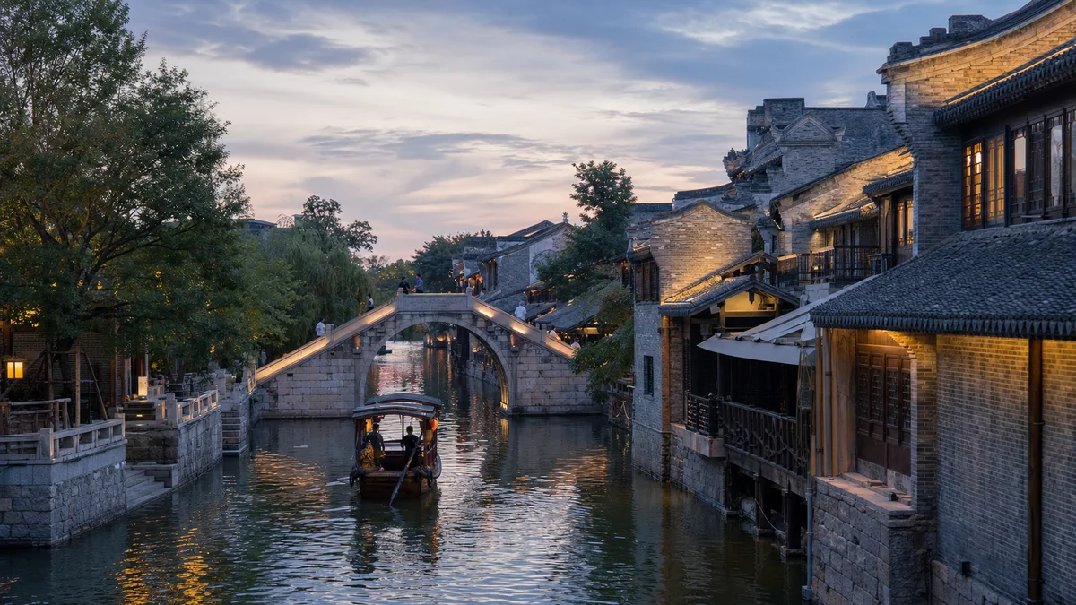
5A View location, maps and nearby scenic areasStand on a bridge before you look for the best-lit façade. Watch the canal turn beneath it: a boat route, a mirror for new buildings, and a reminder that this town existed because cargo once had to move. Then look at the masonry beside the water. Some pieces preserve earlier fabric; much of the coherent “ancient city” around you was built in the twenty-first century.
Taierzhuang asks visitors to hold three histories at once. It was a working Grand Canal port. It became a battlefield in 1938. It is now a large reconstructed cultural-tourism town. None of those histories cancels the others, but confusing them produces an easier and less honest visit.
Orient yourself through three layers: canal and wharf spaces explain trade; battle remains and museums explain 1938; reconstructed streets, boats and evening lights explain how the town presents both pasts today. Read labels before deciding whether a wall is surviving, restored, reconstructed or staged interpretation.
The Grand Canal turned a settlement into a port
Taierzhuang’s commercial rise was tied to changes in the Beijing–Hangzhou Grand Canal. In the late Ming period, a canal route using the Jia River system helped shipping avoid dangerous and unstable stretches associated with the Yellow River. Traffic was directed through this area, and Taierzhuang developed as a transfer, storage and service point.
Grain shipments and commercial cargo required more than water. Boats needed locks and managed channels, crews needed food and lodging, goods needed warehouses and accounts, and damaged vessels needed materials and labour. A bend, landing or narrow water gate can therefore say more about the old town’s purpose than an ornamental arch.
The port flourished especially under the Qing, when north–south movement drew merchants and regional associations to the town. Present maps often turn this into a simple line of “famous shops.” The historical system was a network of waterways, roads, yards, markets and risk: flood, silt, delayed cargo, debt and changing canal policy could reshape livelihoods.
Commerce depended on boatmen, porters and households
Guildhall-style buildings and shopfronts represent merchants with enough capital to build and leave names. The canal also depended on boat crews, trackers where used, porters, carpenters, cooks, inn workers, clerks, guards and vendors. Families kept businesses running while relatives travelled, and residents absorbed the noise, waste and fluctuating prices of a transport town.
Architecture followed those connections. Merchants from different regions carried building preferences, religious practices, food and business customs with them. A reconstructed courtyard may demonstrate that variety, but it is not automatic proof that the entire present building survived from a particular merchant group.
At each commercial exhibit, look behind the finished product. Where was stock stored? How did it reach the boat? Who measured it, carried it and bore the loss if water damaged it? These questions return labour to a streetscape that night lighting can make almost frictionless.
The 1938 battle belonged to a larger invasion
The Battle of Taierzhuang took place in March and April 1938 during the Second Sino-Japanese War. Japanese forces had advanced through northern and eastern China and sought to converge on Xuzhou, a strategic rail and road junction. Taierzhuang lay on an approach to that wider objective.
Fighting moved through villages, canal lines and the town itself. Artillery, street combat, repeated assaults and counterattacks turned buildings and lanes into defensive positions. The canal landscape that had carried trade now channelled movement and obstructed it; walls and houses became cover, traps and targets.
Chinese forces forced the attacking Japanese units to withdraw from the immediate battle, and the result became an important early Chinese tactical victory after a series of defeats. “Victory” needs its scale: Japanese operations continued, Xuzhou was abandoned in May, and the war lasted until 1945. A local success could raise morale without reversing the invasion.
Li Zongren coordinated a battle fought by many
Li Zongren, commander of China’s Fifth War Zone, held overall responsibility for the theatre and coordinated forces around Taierzhuang. His decisions on concentration, defence and counterattack are central to the battle’s history, and his later memoirs helped shape how it has been remembered.
He did not fight alone. Units defending the town, forces attacking Japanese flanks and rear, junior officers, medics, engineers and ordinary soldiers all determined the outcome. Command structures and unit designations can be dense; a good exhibition should show how the parts related instead of reducing the battle to one portrait.
Nor should later political careers decide who is visible. Nationalist forces conducted the battle in 1938, before later phases of China’s civil war reshaped public memory. Recognising that context is not choosing a present-day political side; it is keeping the wartime chain of command historically legible.
Civilian loss sits outside the victory tableau
Taierzhuang was not an empty fortress. Residents lived among shops, courtyards, temples, warehouses and canal landings before armies turned them into positions. Families fled, were separated, lost homes and stock, and faced injury or death. Exact military and civilian casualty figures vary among sources and definitions, so beware of numbers offered without a clear boundary.
The destruction also continued after an individual firefight ended. Ruined housing, disrupted transport, missing relatives, illness and loss of income followed survivors. Reconstruction photographs naturally emphasise what was rebuilt; they can make displacement and grief harder to see.
Inside memorial spaces, look for names, letters, civilian objects and medical evidence—not only weapons and maps. A tactical diagram explains movement, but a burned household object explains what it meant for war to move through a town.
Today’s ancient city is a reconstruction with evidence inside
War, later demolition, altered waterways and decades of urban change left no complete traditional town waiting to be reopened. The present scenic area grew from a large-scale reconstruction project launched in the late 2000s. It recreated streets, canals, bridges, guildhall forms and regional architectural styles on a city-sized scale.
That does not make every part “fake,” nor does it make the whole place original. Surviving fabric includes labelled older structures, foundations or battle-damaged remains. Restoration repairs and completes historic material. Reconstruction recreates missing buildings or patterns. Interpretation uses sets, figures, sound and multimedia to tell a story.
The categories can occupy one view. A protected wartime wall may stand beside a rebuilt courtyard and face a newly managed canal. Read the plaque for each element. Shell marks, for example, should be accepted as wartime evidence only where conservation information identifies them—not because a wall looks distressed.
Use daylight for evidence and night for interpretation
For a focused daylight route, begin with canal orientation: landing, bridge, water gate or warehouse story. Continue through commercial streets while asking how goods moved, then enter one substantial battle exhibition or preserved site. This gives trade and war equal time before the entertainment lighting begins.
For a full day, spend the middle hours at the battle memorial material, when you still have attention for documents and difficult testimony. Return to the canal towards dusk. The evening transformation—reflections, lanterns, shops and performance spaces—is worth seeing precisely because you already know it is a contemporary layer.
Night is more atmospheric but often more crowded and less useful for reading masonry. Day can feel less spectacular but makes reconstruction joints, labels and daily operations clearer. Do not ask which is “better”; decide whether your priority is evidence, atmosphere or the comparison between them.
Boats, shows and accessibility can change
A canal boat can restore the low viewpoint of historical transport, but today’s ride is a visitor service, not a grain voyage. Routes, boarding points, wait times and operation depend on water level, weather, maintenance, staffing and crowd control. Performances and lighting also change by season and event. Confirm official same-day information rather than building the entire visit around one departure or show.
Canals add edges, bridges and wet surfaces. Keep children away from unguarded water, and take care on polished paving in rain or after evening cleaning. Boats may have steps, gaps or moving boarding surfaces; ask about current assistance before assuming wheelchair or stroller access.
Main streets can be relatively level, but stone bridges, thresholds, memorial buildings and crowds interrupt step-free movement. Ask for an accessible route at the current entrance and identify a land-based alternative to any boat segment. Transport, parking controls and late return options can also change during festivals or peak periods.
Photograph with context and remember without performance
In daylight, photograph along the canal so warehouses, bridge and street align; the relationship explains the port better than an isolated façade. At night, reflections can show reconstruction as a deliberate modern composition. Caption it honestly. A beautiful twenty-first-century rebuilding does not need an invented Ming- or Qing-dynasty date.
At battle ruins and memorials, follow restrictions on flash, tripods and photography. Do not climb damaged walls, touch weapons or pose in mock combat. Avoid celebratory gestures beside casualty displays, and do not turn contemporary Japanese visitors or people into targets of inherited blame. Historical responsibility and present-day harassment are not the same thing.
End where you began, on a bridge above the moving water. The reflections may now carry merchant halls, shattered 1938 streets and new façades in the same frame. Taierzhuang’s value lies neither in pretending nothing changed nor in dismissing reconstruction. It lies in learning which layer you are seeing—and remembering the workers, soldiers and civilians who could not choose when the canal town changed around them.
The LoreLens app helps distinguish canal history, wartime remains, restoration and contemporary reconstruction as you walk Taierzhuang.
Location profile
Where it is

Frequently asked questions
How much time should I allow for Taierzhuang Ancient City?
A focused half day can cover the canal-port story, selected commercial streets and one serious battle exhibition. Allow a full day into evening if you want to read memorial sites slowly, compare reconstructed and surviving fabric, and then see the lights without rushing.
Is today's Taierzhuang an untouched ancient town?
No. The present scenic town is the result of large-scale reconstruction begun in the late 2000s after earlier destruction and change. It incorporates some surviving structures, wartime remains and inherited waterways, but many streetscapes, guildhall-style buildings and visitor facilities are contemporary reconstructions.
What happened at the Battle of Taierzhuang?
In spring 1938, during the wider Xuzhou campaign of the Second Sino-Japanese War, Chinese forces under the Fifth War Zone fought Japanese units in and around the town and won an important tactical victory. The battle caused severe military and civilian losses and did not end the campaign or the war.
Do canal boats and performances run every day?
Do not assume so. Boat routes, boarding points, shows and lighting can change with water conditions, weather, maintenance, season, crowd control and special events. Check the attraction's current official schedule and treat them as optional additions to a walking visit.