Yunnan · Kunming
The Stone Forest: A Seabed That Was Dissolved Away
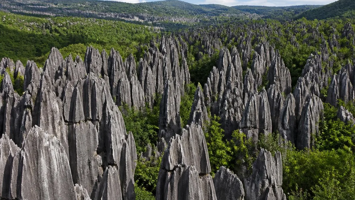
The pillars are not trees and never were. They are what is left of a shallow Permian sea after rainwater spent millions of years running down the cracks in it—and the landform is named after this place in the international literature.
5A View location, maps and nearby scenic areasThe name is the first thing to put aside. There is no forest here and there never was: no petrified trunks, no fossil wood, nothing organic in the pillars at all. What stands in Shilin County, east of Kunming, is limestone—a shallow tropical seabed, lifted onto a plateau and then taken apart from above by rain.
That is the whole story, and it beats the trees. The blades you walk between are the parts of a rock mass that water failed to remove; the corridors are the parts it did. And the landform has been studied here so thoroughly that the Chinese word for it, shilin, is now the international term for the type.
A Permian seabed, in layers you can count
Around 270 million years ago, in the Early Permian, this part of Yunnan lay under a warm shallow sea. Carbonate mud, shell debris and dead marine organisms accumulated on the floor and hardened into several hundred metres of limestone and dolomite. Two formations matter, and the difference between them is visible on site.
The Maokou Formation is nearly pure limestone, dominated by calcite, and it hosts the Greater and Lesser Stone Forests. The older Qixia Formation is dolomite and dolomitic limestone, carrying magnesium as well as calcium, and it hosts Naigu, some nine kilometres northeast. Together the two are given as around 505 metres thick, with at least one chert band.
The fossils are mostly gone from the Maokou rock, heavily altered by later chemical change, but under a microscope you can still find fusulinid foraminifera—single-celled marine organisms shaped like grains of wheat—whole or broken in the fine-grained matrix. That is the seabed, still legible, holding up a tourist walkway.
Beneath the carbonates lie the impermeable sandstones and shales of the Liangshan Formation, a floor that forces groundwater here to move sideways, west to east, rather than draining away downwards.
Why it dissolves into blades and not into caves
Limestone dissolves in slightly acidic water: rain picks up carbon dioxide from air and soil, becomes weak carbonic acid, and takes carbonate rock into solution. Where that water goes decides what shape is left behind, and here it was decided by fractures.
The beds are tilted very gently—a monocline dipping west at only two to six degrees—and cut by well-developed conjugate shear joints in two directions. Before any karst existed, those fractures were the only easy pathways through an otherwise tight rock. Water found them, and everything since has amplified that first choice.
The mechanism is easy to picture. Water runs down a vertical crack, dissolving the walls; the crack becomes a groove, the groove a corridor, and the corridor deepens faster than it widens because the flow concentrates at the bottom. What stands between two corridors is a blade. Do that along two intersecting joint sets for long enough and you get a grid of freestanding columns—which is what the aerial view of Shilin shows.
The literature is blunt about it: fracture distribution, spacing and orientation determined the depth, size and alignment of the karst. The pillars are the negative image of a crack pattern.
Fire, water, and the burial that let it survive
A single episode of dissolution would not produce what is here. The official account runs through several environments, and two of them explain why forms of very different ages sit side by side.
After the Permian sea withdrew, uplift put the limestone at the edge of a humid tropical coast, and the earliest stone forest formed there. Then came fire: volcanic eruptions buried the whole area under thick basalt. Most of that cover has since been stripped off, but while it was there it sealed the early pillars away from further dissolution.
Through the long Mesozoic and early Cenozoic the region was planed down. Around 60 million years ago the early Himalayan movement tilted and lifted it again into an inland basin holding a lake—the Lunan palaeolake—so some stone forest developed under water and lake sediment. Uplift then continued towards the plateau valley landscape it occupies now.
Fire and water, in the site’s own phrasing. The consequence is that Shilin holds stone forests of several generations—tropical coast, lake, plateau—inheriting and overlapping one another. That is the real basis of the claim that the place shows 270 million years of landscape evolution, not that any one pillar is that old.
One correction while we are here. Naigu is noticeably darker than the main stone forest, and this is often put down to the basalt. It is not that. By the scenic area’s own explanation, the Greater Stone Forest is pale grey because its rock is fairly pure limestone dominated by calcite, while Naigu’s is dolomitic and siliceous limestone, carrying dolomite and chert, which weathers much darker; moss and lichen deepen it further. Same rain, different chemistry.
The type locality, and what UNESCO actually inscribed
Karst has its own vocabulary and most of it is European—the word is a plateau in Slovenia. Three exceptions come from southern China, and one is this place.
The style is sword-shaped karst in Chinese and pinnacle karst in English: tall, densely packed blades separated by deep dissolution corridors. The pinyin term shilin has itself entered international karst writing as a name for the type, alongside fenglin for tower karst and fengcong for cone karst, and South China is treated as the global type area for all three. The World Heritage citation is unusually direct about the ranking: it calls Yunnan Shilin the world’s best example of stone forest landform and the model locality for the type, holding a richer range of sword-karst forms, and more variation in shape and colour with weather and light, than other places where this landform develops. Comparisons usually reach for the tsingy of Madagascar, pinnacle karst too and sharper; Shilin’s distinction is variety and completeness rather than any single superlative. In 2022 Shilin Karst entered the first list of 100 geological heritage sites published by the International Union of Geological Sciences—a peer-selected register, not a tourism award.
What it does not hold is a World Heritage listing of its own, and that is the point most travel writing gets wrong. On 27 June 2007, at the 31st session of the World Heritage Committee in Christchurch, South China Karst was inscribed as a serial property—China’s first cross-provincial joint nomination, its sixth natural World Heritage site, Yunnan’s third and Kunming’s first. The first phase comprised three clusters: Shilin Karst in Yunnan, Libo Karst in Guizhou and Wulong Karst in Chongqing. A second phase in 2014 added Guilin, Shibing, Jinfoshan and Huanjiang, bringing the property to about 97,125 hectares with a buffer zone of some 176,228.
Within the Yunnan cluster the committee singles out the Naigu Stone Forest, developed in dolomitic limestone, and a stone forest standing in a lake; the heritage area in Shilin’s own description covers 1,100 square kilometres with a protected zone of 350. The designation attaches to defined zones and buffers—not to the county, and not to everything sold under the name. Shilin had proposed itself once before, in 1991, and withdrew its own application when the technical preparation was judged insufficient.
The zones, and what each one is like
The scenic area is far larger than the walkway most visitors see, and the sub-areas genuinely differ.
The Greater and Lesser Stone Forests, also called Lizijing, are the core: pale grey Maokou limestone, the densest pillars, the paved circuit, the crowds and the Ashima rock. This is the postcard, and a two-hour walk if you do not rush.
Naigu, marketed as Heisongyan or Black Pine Rock and covering around ten square kilometres, is the other face: dark dolomitic pillars, much more open ground between them, fewer people, and caves underneath—the area is honeycombed with them. Bleaker and more austere than the main forest, which is the reason to go.
Long Lake and Moon Lake are dissolution lakes on the plateau, the first a long finger of water between low hills; Zhiyun and Qifeng are caves, the latter known for an airflow that comes and goes. Dadieshui, also called Feilong Falls, sits roughly 25 kilometres southwest of the county town: a two-stage drop with the main tier usually given as about 88 metres and the total around 92, roughly 30 metres wide. It is advertised as the highest waterfall on the Pearl River system, a claim to check rather than repeat, and it depends heavily on season—come in the wet months or expect a trickle.
Ashima, in three layers that should not be merged
The most famous thing here after the rocks is a girl who turned into one. Her history is more complicated than the signboard.
Layer one is oral literature. Ashima is a narrative poem of the Sani, a branch of the Yi people who live in this county. It is composed in five-syllable lines, chanted rather than read, and performed at weddings, funerals, births, work and ritual, with different tunes for different occasions. It draws on Yi religious scripture, is treated by some as a religious text, and survives in dozens of variants split between northern and southern performance traditions. It entered China’s first national list of intangible cultural heritage in 2006.
Layer two is state redaction. In 1953 a Chinese version was compiled by Huang Tie, Yang Zhiyong, Liu Qi and Gong Liu, running to 1,892 lines; seven more followed. The 1953 text made the poem nationally famous, and later scholars have criticised it for departing from the oral tradition—including its reading of the whole poem as class struggle, an interpretation now generally abandoned.
Layer three is cinema, and it changed the story. A film was shot in 1964 by the Haiyan Studio in Shanghai, directed by Liu Qiong and starring Yang Likun—China’s first colour widescreen stereo musical. It was not released: during review it was condemned as promoting love above all else, its makers were persecuted in the Cultural Revolution, and it was shown publicly only in 1979.
The change it made is the important one. In the poem, Ahei and Ashima are brother and sister—all twenty-nine primary collected texts say so, and Shilin performers were still saying so in fieldwork in 2012. The film made them lovers, added a torch festival scene and a flood released by the landlord, and that is the version almost everyone now carries. The Ashima rock in the Lesser Stone Forest belongs to the same process: a pillar matched to a story, pointed out afterwards.
The Sani, and a festival with a fixed date
The people whose poem this is are still here. The Sani are a subgroup of the Yi, with their own language and script, and Shilin is a Yi autonomous county. The tradition-bearers on the intangible heritage register are named individuals—one known for the folk modes, another for the bimo priestly recitation.
The Torch Festival falls on the 24th day of the sixth lunar month, which puts it in high summer, and it is a real festival rather than a show staged for visitors, even though the county now also runs an international carnival around it. The daytime programme is wrestling and bullfighting; the evening is torches, bonfires and dancing to the large three-stringed lute. In recent years the fire has been kindled by a bimo on a mountaintop, with a drill and a fire-making scripture, before the torches go out to the villages. Expect the county to be full at that time; if you have come only for the rocks, avoid it.
Who named it, and whose signature is on the sign
The pillars are old; the name on the gate is not, and the sequence behind it is a small lesson in how heritage gets assembled. Qing gazetteers already describe the place. The Kangxi-era Lunan Prefecture Gazetteer records cliffs tens of ren high, reached only by climbing, with strange rocks standing in ranks like a thousand troops and ten thousand horsemen, all blue-grey, interlocking and intricate, with no end to be found when you search them.
The modern name dates to 1931, when Long Yun, then chairman of Yunnan province, passed through, gave the place the name Shilin and had a park established. The calligraphy of the original inscription was by Zhou Zhongyue, and it was destroyed during the Cultural Revolution. Afterwards the tourism authorities wanted it back, could not find the original hand, and composed the two characters instead from the Cuan Baozi stele—an Eastern Jin memorial tablet of 405 CE held at Qujing No. 1 Middle School. The signature line reading “inscribed by Long Yun” was written in September 1985 by his son and carved by the county. Zhu De visited in 1962 and improvised eight characters, but there was no paper left to sign them, so the signature carved beside them was copied from another of his inscriptions.
Two characters recomposed from a fifth-century stele, signed by the son of the man credited, beside a borrowed signature. Read it beside the Ashima history and the pattern is the same: a real thing, then a national version of it, then an object pointed at.
The administrative dates are cleaner: one of China’s first national key scenic areas in November 1982, under the legal name Lunan Stone Forest; a national geopark in 2001; and in February 2004, a member of the first cohort of Global Geoparks.
Getting there, and moving around inside
Shilin is an easy day trip from Kunming and a better overnight one. By rail, high-speed trains from Kunming South reach Shilin West in roughly twenty to thirty minutes; bus route 99 runs from that station to the scenic area in about fifty minutes, at roughly twenty-minute intervals. By road, coaches from Kunming’s eastern or southern bus stations take about two hours. Distances quoted from Kunming disagree badly—78, 86, 90 and 120 kilometres all appear in print, depending on whether the endpoint is the city edge, the county town or the park gate—so treat any single figure as approximate.
Inside, plan for size rather than difficulty. The core Greater and Lesser Stone Forests are a paved circuit with steps and narrow passages; an electric shuttle links the main zones, and walking between areas is not practical. Naigu has its own entrance nine or so kilometres away, and Long Lake and Dadieshui are separate trips again. A combined ticket with a multi-day validity has been reported, plus a small charge for the shuttle, but prices, validity, shuttle fares and opening hours all change—confirm at the gate rather than trusting any figure written in advance, including these.
The altitude sits between roughly 1,500 and 1,900 metres, the climate is Kunming’s famously mild one, and there is little shade. Summer brings the rain that makes Dadieshui worth the detour and the limestone slippery. Go early whatever the season: the corridors are narrow, and the whole point is being between two walls of rock with nothing else in view.
What you are actually standing in
Before you leave the core forest, find a corridor narrow enough to touch both sides, and put a hand on each wall. Those two surfaces were once the two faces of a single crack in a slab of seabed, close enough to be one rock. Everything that filled the space you are standing in has been carried away in solution, molecule by molecule, and delivered to a river.
That is why the name misleads in a useful way. A forest grows upward. This grew downward, and the trees are the gaps.
The LoreLens app can identify karst pillar forms, dissolution features and rock types in the Stone Forest, and explain how each one formed.
Location profile
Where it is

Frequently asked questions
Is the Stone Forest really a UNESCO World Heritage Site on its own?
No—and the distinction matters. Shilin Karst is one component of a serial property called South China Karst, inscribed on 27 June 2007 at the 31st session of the World Heritage Committee in Christchurch. It went in alongside Libo Karst in Guizhou and Wulong Karst in Chongqing as the first phase; a second phase in 2014 added Guilin, Shibing, Jinfoshan and Huanjiang. It was China's first cross-provincial joint nomination, and the whole property runs to about 97,125 hectares with a buffer zone of some 176,228. The committee's evaluation of the Yunnan component singles out the Naigu Stone Forest, developed in dolomitic limestone, and a stone forest standing in a lake—so what is inscribed is a set of defined zones, not the entire scenic area or county.
What is 'sword karst' and why is it associated with Shilin?
It is the landform class the English literature usually calls pinnacle karst: tall, closely spaced blades and columns of soluble rock separated by deep dissolution corridors. Chinese usage calls it jianzhuang kasite, sword-shaped karst; the pinyin term shilin has itself entered international karst writing. South China is treated as the global type area for three karst styles—fenglin tower karst, fengcong cone karst and shilin stone forest—and the World Heritage citation calls Yunnan Shilin the best example of stone forest landform in the world and the model locality for the type, noting that it holds a wider range of sword-karst forms and colours than other places where this landform develops. In 2022 Shilin Karst was named to the International Union of Geological Sciences' first list of 100 geological heritage sites.
Was Ashima a real person?
Ashima is a Sani narrative poem, not a biography, and the way it reached the public has three distinct stages worth keeping apart. First, an oral tradition: a five-syllable verse epic among the Sani, a branch of the Yi, chanted at weddings, funerals, work and ritual, with dozens of recorded variants. Second, a state redaction: a Chinese-language version compiled in 1953 by Huang Tie, Yang Zhiyong, Liu Qi and Gong Liu, running to 1,892 lines; eight Chinese versions exist, and scholars have criticised the standard one for departing from the original. Third, a film: shot in 1964 by the Haiyan studio, condemned before release and shelved, and only publicly shown in 1979. The film changed Ahei and Ashima from siblings—which is what every one of the twenty-nine primary collected texts calls them—into lovers, and that is the version most people now believe. The Ashima rock in the Lesser Stone Forest is a later identification, a place matched to a story rather than the reverse.
How do I get there from Kunming, and how much walking is involved?
By rail: high-speed trains from Kunming South reach Shilin West in around twenty to thirty minutes, and bus route 99 runs from that station to the scenic area in roughly fifty minutes. By road: coaches from Kunming's eastern or southern bus stations take about two hours. Quoted distances from Kunming vary widely—78, 86, 90 and 120 kilometres all appear in print, depending on whether the measurement is to the county, the park gate or by which road—so treat the figure as approximate. Inside, the park is very large and split across separate areas; an electric shuttle links the main zones, and the Greater and Lesser Stone Forests alone take a couple of hours on foot. Naigu, Long Lake and Dadieshui are separate trips. Ticketing, shuttle fares, validity periods and opening hours change, so confirm at the gate on the day.
Sources and further reading
Background references for the history and place names in this guide. Opening hours, ticketing and access change often — always confirm with official local information before travelling.