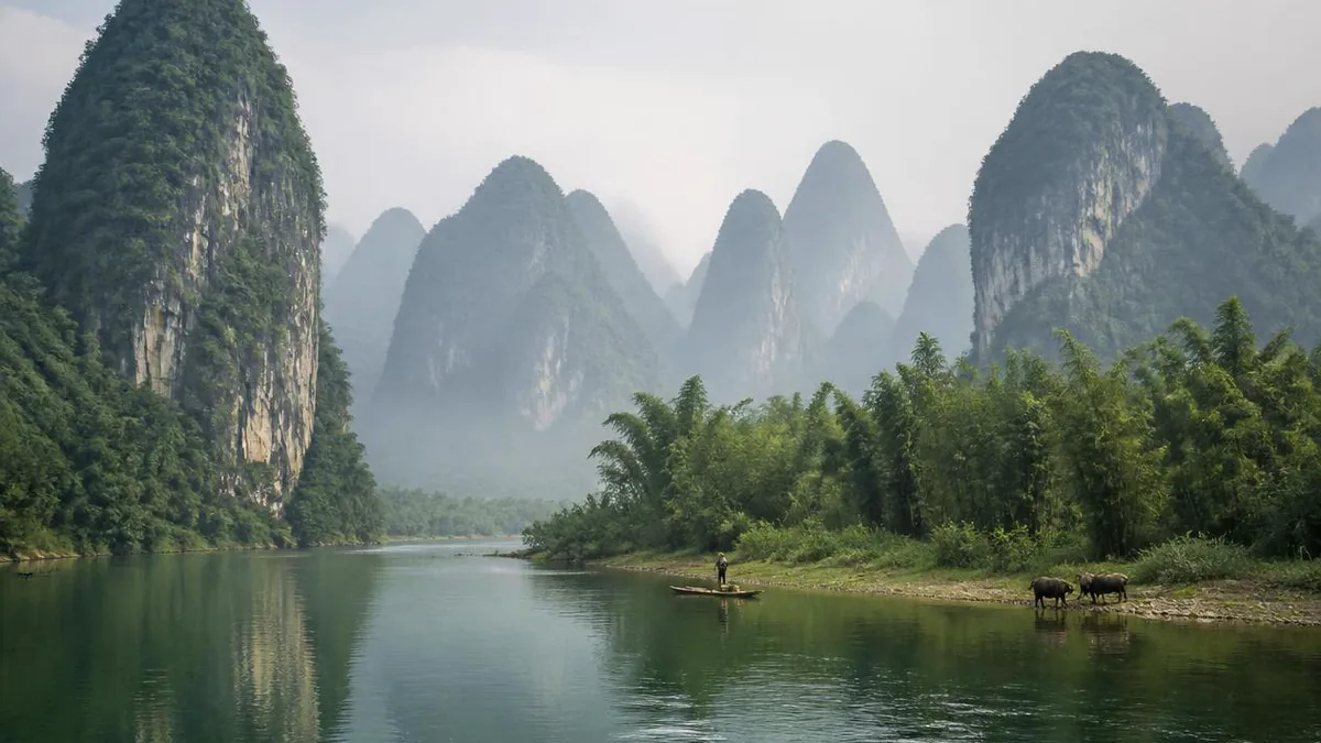
Guangxi · Guilin
The Li River: A Cross-Section of Karst in the Act of Changing
The 83 kilometres everyone books between Guilin and Yangshuo is not simply a pretty river. It is the stretch where one kind of limestone landscape is turning into another, and where the water level, not the season, decides whether a boat sails at all.
5A View location, maps and nearby scenic areasNobody books the Li River. They book eighty-three kilometres of it.
The river itself is longer than that, and less tidy. It runs about 164 kilometres from Xing’an County to Pingle County, where it takes on other tributaries and becomes the Gui, which eventually reaches the Pearl River delta. Above Guilin it is called the Da Rong Jiang. Below Pingle, it is not the Li at all. The part that made the name is a single reach in the middle, from Guilin down to Yangshuo, and it is famous for a reason that has almost nothing to do with the water.
That reach is where one kind of limestone landscape is visibly turning into another.
Why the trip is exactly eighty-three kilometres long
The commonly published figure for the Guilin to Yangshuo run is 83 kilometres, usually flown as four to five hours on a large boat. The drop over that distance is small: the river surface is given as about 141 metres at Guilin and about 103 metres at Yangshuo, so roughly 38 metres of fall across the whole cruise. Mean flow past Guilin is quoted at about 215 cubic metres per second.
Those numbers explain the character of the trip. This is not a gorge run. The current is gentle, the channel is broad, and the boat moves at the pace of a slow bicycle. What changes is the shape of the ground on either side, and it changes in a particular direction.
Operators divide the run into three parts and are honest about which one matters. The first, from Guilin down past Elephant Trunk Hill, Chuanshan and the old town of Daxu to Ox Gorge, is the approach. The second, from Ox Gorge down through Yangdi, Nine-Horse Fresco Hill, the Yellow Cloth Shoal and Xingping, is what people came for. The third is the run-in to Yangshuo. Most bus-and-boat packages skip the first section by driving an hour downstream to the Zhujiang or Mopanshan piers.
Peak cluster and peak forest: two karsts, one boat ride
The specialist vocabulary here is worth twenty minutes of your attention, because it converts a blur of hills into a sequence.
Fengcong, peak-cluster karst, is a group of limestone hills that share one continuous rock base, with deep closed depressions — dolines — sitting between the summits. The hills are joined at the bottom. It is sometimes described in English as peak-cluster depression karst, and it dominates the middle course of the Li, the part the boat threads through.
Fenglin, peak-forest karst, is the opposite arrangement: isolated towers rising from a flat limestone surface generally buried under loose sediment. It is sometimes called peak-forest plain. This is the landscape around Yangshuo and south of Guilin, and it is the one that has been painted for a thousand years.
The towers have a measurable signature. Their sides are near-vertical because the limestone is strong and massive, and base diameters are typically less than 1.5 times the tower’s height. Heights run about 30 to 80 metres in the central basin, and can approach 300 metres near the peak clusters.
Once you have those two words, the cruise reads as a transect. You start in the joined-up hills and end among the free-standing ones.
The rock had to be very close to perfect
Karst forms wherever slightly acidic water meets carbonate rock: rainwater plus atmospheric carbon dioxide, plus more carbon dioxide generated biologically in the soil, produces weak carbonic acid, which takes calcium into solution and carries it away. That process is common. Landscapes like this one are not.
The difference is the quality of the limestone. Chinese sources describe the Guilin carbonate sequence as extremely pure and extremely thick, with a porosity under 1 percent, and offer a comparison that makes the point better than any adjective: Tertiary limestone in Florida is put at around 16 percent. Low porosity means water cannot seep through the body of the rock. It has to travel along joints and fractures instead, which is why dissolution here cuts sharp vertical faces rather than crumbling slopes.
Thickness and age carry a real disagreement. English-language geological summaries give about 2,600 metres of Devonian and Carboniferous limestone in the Guilin basin. Chinese accounts put the carbonate sequence at over 3,000 metres and date its deposition to roughly 320 to 400 million years ago, which is the same interval. A separate English summary of Guilin describes the surrounding karst as Triassic, which does not agree with either, and which we would not repeat. Take the Devonian–Carboniferous framing, which two independent traditions support, and treat the thickness as somewhere between 2,600 and 3,000-plus metres depending on where the section is measured.
Uplift does the work that water cannot
Dissolution alone would eventually flatten this landscape. Towers exist because the ground keeps rising.
The published model is that fenglin evolves out of fengcong through slow, continuous tectonic uplift associated with the Himalayan orogenic belt, combined with erosion of the towers that is slower still. Development of both types in the Guilin basin is placed in the Cenozoic, over roughly the last 10 to 20 million years.
That ordering has a consequence you can see from the deck. Where the base of the limestone is being lowered towards the water table and planed flat, depressions merge into a corrosion plain and the residual hills are left standing alone: fenglin. Where uplift has been faster or the plain has not yet formed, the hills remain welded at the base with closed hollows between them: fengcong. The Li River, running down the middle of the basin, happens to cross the boundary.
International karst literature treats the Guilin–Yangshuo area as the type example of peak-forest karst worldwide. That is a scientific judgement about a landform class, not a beauty contest, and it is the more interesting claim of the two.
What is underneath the postcard
The same fractures that steepen the towers drain the basin internally, and the result is a large and mostly invisible cave system.
Hundreds of caves are recorded along the river corridor. Twenty-three of them are described as having passages longer than a kilometre in the Li River gorge alone, and the longest system, the Guanyan complex, is described as extending from Caoping to Nanxu. Its show-cave section, opened to visitors in the mid-1990s and known in English as Crown Cave, is quoted at around 12 kilometres of water-eroded passage, fitted out with lighting, escalators and internal boats.
This underground half is why the surface has so little standing water between the hills. Rainfall drains down joints rather than across the plain. The rice paddies you see from the boat sit on alluvium the river laid down; the hills behind them are effectively dry.
The line that sold the river was written for an exam banquet
The phrase attached to this landscape everywhere — that Guilin’s mountains and waters are the finest under heaven — has a specific and rather unromantic origin, and its recovery is a modern story.
It is the opening line of the second of two poems carved above the mouth of Dushu Yan, the Reading Cave, at the foot of Duxiu Peak in the old Jingjiang princely city in central Guilin. The preface dates the occasion precisely: the first year of the Jiatai reign, which is 1201, when Guilin held its provincial examination and eleven candidates qualified; on the sixteenth day of the ninth month the customary banquet was held; and the judicial intendant acting as prefect, Wang Zhenggong (1133–1203), wrote the poems to send the candidates on to the capital. A student named Zhang Ciliang had them cut into the rock.
Read in context the famous line is a compliment aimed at the young men in the room, not at the scenery. The couplets that follow compare the examination hall to a battlefield at full pitch and the graders’ gates to tigers and leopards. It is a pep talk.
The identification of this carving as the source is recent. A 2002 article in the provincial gazetteer journal Guangxi Difangzhi by Liao Guoyi and Lu Jun is titled, in translation, “The discovery of the Southern Song ‘Guilin’s landscape is finest under heaven’ inscription at Duxiu Peak and its tourism value” — the word discovery is theirs. Popular accounts commonly date the find to the 1980s and often to 1983 specifically; we could not confirm a year from a primary source, so treat the decade as reliable and the year as unverified. Either way, a slogan in circulation for eight centuries only acquired a confirmed author within living memory.
Duxiu Peak itself is worth the detour: about 216 metres above sea level and 66 metres above the surrounding ground, reached by a stair usually counted at 306 steps, and carrying inscriptions from the Tang onward. The peak’s carvings were listed as a municipal protected site in 1966, provincially in 1994, and nationally in 2001 as part of the Guilin Stone Inscriptions.
Water level, not weather, decides your trip
This is the practical heart of the article, and it is chronically under-explained.
The high-flow period is generally given as April to October; the dry period as November to January, when the shallowest stretch of the navigable channel is described as under one metre deep. A Chinese-language description of Yangshuo town says plainly that the cruise boats do not operate in winter because of water levels. English travel sources put it more gently, saying only that the river does not show its best in those months. The two statements are not really in conflict — what actually happens at low water is a sliding scale.
In descending order of severity: full-route large boats stop and departures move to piers further downstream; large boats are replaced by small motorised rafts on the Yangdi–Xingping section; and in the worst weeks nothing runs at all. None of this is scheduled in advance, because it depends on gauge readings.
The other extreme is real too. On 7 June 2020 Yangshuo County recorded 327.7 millimetres of rain in a day, a local record, with 296.1 millimetres falling in fourteen hours; upstream releases combined with the downpour to flood the county town, West Street included, and a small reservoir dam in Gaotian failed. The Li is a monsoon river in a basin that receives close to 1,890 millimetres a year, about half of it between April and June. Plum-rain flooding and winter shallows are the same fact seen from two ends.
So: decide the cruise in the week you travel, not the month you book, and confirm at the pier.
The banknote question, honestly
You will be told, more than once, that the back of the fifth-series 20-yuan note is this river. That much is not disputed. Where it was drawn is.
Three named claims circulate. One places it at the Yellow Cloth Shoal, where a broad cream-coloured slab of rock under the surface gives the shoal its name and seven peaks on both banks — locally the Seven Fairy Maidens — cast the reflections the reach is known for. A second names Fuziyan, near Xingping. A third simply says the Xingping pier area. All three sit within a few kilometres of each other in Xingping town, Yangshuo County, and none has been checked against a statement from the issuing bank. We are leaving it as a disagreement.
For photography the answer is the same regardless. The Yellow Cloth Shoal lies about 500 metres downstream of Nine-Horse Fresco Hill; from a cruise boat you want the stern rail and a backward shot, because the vessel clears it quickly. From a raft you can go ashore at the shoal landing.
Rafts, footpaths, cormorants: what is still real
A small honesty first, because the expectation is universal and wrong.
The rafts working the Yangdi to Xingping section are, in the main, no longer bamboo. They are assembled from plastic pipe, usually with a small two-stroke outboard on the back, and painted to look the part. They multiply after the big cruise boats have gone through; the better operators supply life jackets. The traditional bamboo craft still exists as a form, and unpowered bamboo rafts remain the norm on the Yulong, a separate river inland, but on the main Li you should expect pipe and an engine.
The quiet alternative is on foot. A riverside track between Yangdi and Xingping is commonly given as 18 to 24 kilometres, five to six hours, with two or three river crossings that have to be made by ferry raft and which are not always operating. Walkers get the same hills at a tenth of the noise, and can stop where a boat cannot.
Two older river traditions deserve a note in the same breath. Cormorant fishing is genuinely local and genuinely old, and it is now mostly a paid evening demonstration rather than a livelihood. Xingping’s Fishing Village, founded in the Ming and usually dated to 1506, preserves several dozen residences with the horse-head gables and carved windows of northern Guangxi; it is where the practice is most often shown.
The naming game is the other tradition. Nine-Horse Fresco Hill is a cliff whose mineral staining and vegetation are said to resolve into nine horses, with a long-standing local joke that spotting seven predicts a good examination result and nine a first place. It is a decent illustration of how this landscape has always been read: as a surface to project onto.
You can do better than that from the deck. Watch the bases of the hills instead of their tops. Where they merge into a shared plinth with hollows between, you are in peak-cluster country. Where they rise cleanly out of flat paddy with sediment lapping against vertical rock, the transition has happened.
The boat is a slow instrument
Four hours is a long time to look at hills, and the temptation is to spend it on legends about fairies and jade emperors.
The alternative is that this reach of water is a working cross-section. Some three hundred and more million years of shallow-sea carbonate, stacked kilometres thick and unusually pure; tens of millions of years of uplift under a monsoon climate that supplies both the rain and the soil carbon dioxide; and a drainage system that does most of its cutting out of sight. What arrives at the surface is a landscape mid-transformation, with joined hills at one end of the trip and free-standing towers at the other.
The eight-century-old line carved at Duxiu Peak got one thing right by accident. Wang Zhenggong wrote it to tell eleven examination candidates that they were about to be measured against the whole country. The river he used as the compliment turns out to be a measurement too, of a much slower kind.
The LoreLens app can identify karst tower forms, cave features and riverbank landmarks along the Li River and explain the geology behind them.
Location profile
Where it is

Frequently asked questions
Can you do the Li River cruise in winter, when the water is low?
Sometimes, and it is the single thing worth checking before you book anything else. The dry months are usually given as November to January, when the shallowest reaches of the navigable channel drop to under a metre, and the high-flow season is April to October. One Chinese-language description of Yangshuo town states flatly that the cruise boats do not run in winter because of water levels; travel sources are softer, saying only that the river does not show its best between November and January. Both point the same way. In practice, low water produces some combination of shortened runs, departures moved downstream to piers closer to Yangshuo, substitution of small motorised rafts for large boats, and outright cancellation. None of that is announced far in advance. Treat the cruise as a same-week decision, confirm operations at the pier or through your hotel on the day, and keep a bicycle or the riverside footpath as a fallback.
Where exactly is the view on the back of the 20-yuan note?
Sources agree on the reach and disagree on the exact spot. All the accounts we could check place it in the Xingping stretch, in Yangshuo County, in the most photographed section of the river. Beyond that they diverge: one names the Yellow Cloth Shoal reflections together with a hill usually rendered Yuanbao; another names Fuziyan near Xingping; a third simply says the Xingping pier area. These have not been reconciled against a statement from the issuing bank, so we are not going to pick a winner. Practically it does not matter much, because the boat passes all of them within a few minutes. If you want the postcard, be on the stern deck as the boat clears the Yellow Cloth Shoal, roughly 500 metres downstream of Nine-Horse Fresco Hill, and shoot backwards. Raft passengers can land at the shoal and take their time.
What is the difference between fengcong and fenglin, and can I actually see it?
Yes, and it is the most rewarding thing to watch for. Fengcong, peak-cluster karst, is a group of limestone hills sharing one continuous rock base, with deep closed depressions between the summits; it dominates the middle of the cruise, where the hills come at you in linked ridges and the river cuts through them. Fenglin, peak-forest karst, is isolated towers standing on a flat plain of limestone covered by loose sediment; it dominates around Yangshuo and south of Guilin, and it is the landscape of the paintings. The towers are steep because the rock is strong: base diameters are typically under 1.5 times their height, and they run about 30 to 80 metres high in the central basin, rising towards 300 metres where they meet the peak clusters. Published work treats fenglin as evolving out of fengcong through slow tectonic uplift and slower erosion of the towers, over roughly the last 10 to 20 million years.
Big boat or bamboo raft, and where do they leave from?
They are different trips. The large cruise boats run the full Guilin to Yangshuo route, about 83 kilometres, generally quoted at four to five hours, and depart either from a wharf in central Guilin below Liberation Bridge or, more often, from Zhujiang or Mopanshan piers about an hour downstream by bus, which skips the least interesting water. Passport checks apply at booking and boarding, so allow at least thirty minutes at the pier. The small rafts work the Yangdi to Xingping section only, they are now built of plastic pipe rather than bamboo and usually carry small outboard motors, and they run after the big boats have passed. There is also a footpath along the bank between Yangdi and Xingping, commonly given as 18 to 24 kilometres, with a few river crossings by ferry raft. Fares, pier assignments and which crossings are operating all change; confirm on the day.
Sources and further reading
Background references for the history and place names in this guide. Opening hours, ticketing and access change often — always confirm with official local information before travelling.