Guangxi · Guilin
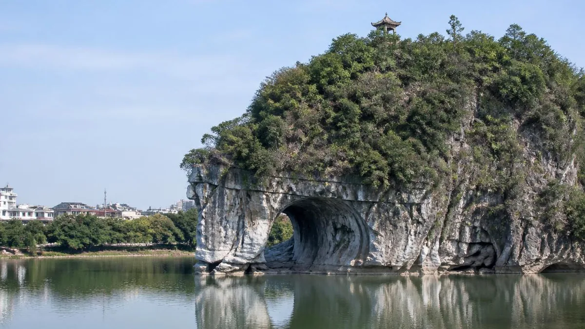
Elephant Trunk Hill: A City Emblem the Size of a Building
Guilin's symbol is a limestone knob about fifty-five metres above the river, in the middle of the city, that for years charged admission to look at it. The rock is small; the fifty-odd inscriptions carved inside its hole are what actually matter.
There is a particular kind of disappointment reserved for people who arrive at Elephant Trunk Hill having seen the photographs.
It is in the middle of Guilin, a short bus ride from the centre, at the point where the Taohua river joins the Li. It is about fifty-five metres of rock above the water. It is the city’s official emblem, it appears on every brochure produced in Guangxi, and for many years the standard visitor experience was to pay to stand behind a wall and look at it.
That gap — between the symbolic weight and the physical object — is the honest subject here. The hill is not a landscape. It is a single boulder-shaped mass of Devonian limestone with a hole through one end, and its genuine content is not the resemblance to an elephant but the fifty-odd texts people carved inside the hole across roughly a thousand years.
The dimensions, plainly
Published figures for the hill converge on about 200 metres above sea level. That number needs converting to be useful. The Li River surface at Guilin is given as roughly 141 metres, which leaves something in the range of 55 to 60 metres of rock standing above the water — and 55 metres is the figure Chinese descriptions most often quote directly.
Commonly circulated dimensions put the mass at around a hundred metres long and a hundred metres wide. The park around it, Xiangshan Park, is given as about 11.88 hectares, which is to say roughly the footprint of a dozen city blocks’ worth of gardens, paths, a temple and a car park.
So: a feature the height of a fifteen- to twenty-storey building, in a city, with a river running past it. Allow forty-five minutes to an hour and a half. The photographs that make it look like a mountain are shot with long lenses from low on the water, which compresses the peaks behind it into the frame.
How the trunk got its hole
The arch between the “trunk” and the “leg” is called the Water-Moon Cave, and its formation is the most interesting geological thing on the site.
Guilin’s karst is built on a very thick and very pure carbonate sequence — Devonian and Carboniferous limestones, described in the English geological literature as some 2,600 metres thick in the basin, and in Chinese sources as over 3,000 metres deposited roughly 320 to 400 million years ago. The porosity of this limestone is exceptionally low, under one percent. Water therefore cannot percolate through the body of the rock; it has to move along joints and bedding planes, which is why dissolution here produces clean vertical faces and sharply defined openings rather than rounded slopes.
A through-cave at river level, like this one, is the product of two processes working together. Dissolution below the water table opens a passage along a fracture; then, as the river cuts down and swings against the foot of the hill, lateral erosion widens and empties it. The result is a hole that goes right through the base of the hill with water flowing under it. There is a second, smaller pierced cavity higher on the flank, which local description assigns to the elephant’s eyes.
The hill’s older name reflects none of this. Before the animal reading took hold it was simply Li Shan, the hill of the Li — a plain locational name of the kind given to river features everywhere. Chinese descriptions date its use as a visited site to the Tang, giving it something close to a thousand years of continuous sightseeing history, which is unusual even in a city as long-settled as this one and is the underlying reason the cave filled up with writing.
The name Water-Moon Cave is a description of an optical effect rather than a metaphor. On a calm night with the moon in the right position, the arch and its reflection close into a full circle on the water — a moon under the water and a moon on it.
Two prefects, one cave, and a fight in stone
The best story attached to this hill is not the one about the Jade Emperor’s mount.
Chinese accounts of the cave describe a disagreement, roughly eight hundred years ago, between two successive Song administrators of Guilin over what the cave should be called. One renamed it and built a pavilion in the arch, arguing for a name referencing the morning sun; his successor argued for restoring the older water-and-moon name and had his case carved into the rock. The pavilion is long gone. Both arguments survive as inscriptions.
We can pin down one half of the pairing with confidence: Fan Chengda, the Southern Song poet, official and travel writer, was appointed to Guilin in 1171, serving as prefect of Jingjiang and then as pacification commissioner for Guangxi, and he wrote Guihai Yuheng Zhi, a detailed account of the region’s geography and products. The other party is usually identified as Zhang Xiaoxiang, who held the same post shortly before him. We could not verify the attribution of the specific texts to specific authors from a primary source, so we present the dispute as reported and the Fan Chengda dating as documented.
What makes it worth telling regardless is the mechanism. Two senior officials disagreed about a place name, and the way they argued was to commission stonemasons. That is what a Chinese cliff-inscription site actually is: an argument archive.
Fifty inscriptions, and why they are the point
The cave walls carry more than fifty carved texts. One English summary dates the earliest to the Song (960–1279); Chinese descriptions more often say the corpus runs from the Tang onward. We could not reconcile these, so the Song floor is the safer statement and the Tang claim should be treated as unconfirmed rather than wrong.
Context makes the number meaningful. The Guilin Stone Inscriptions are a single national protected site, listed in 2001, comprising twenty-two designated points spread across more than twenty hills in and around the city. The whole corpus runs from the Eastern Jin to the Republican period and totals over two thousand carvings, of which close to five hundred are Song — described as the largest concentration of Song-period cliff inscriptions anywhere in China. The landscape poems and travel essays among them come to something on the order of two million characters.
That is the frame Elephant Trunk Hill belongs in. It is not a curiosity shaped like an animal; it is one node in the densest cliff-inscription landscape in the country, and the reason it was carved so heavily is that it stood at a river junction on the edge of the walled city, where every official who passed through would see it.
The pagoda on top
The small brick tower on the summit is the Puxian Pagoda, built in the Ming, and dedicated to Samantabhadra — Puxian — one of the four principal bodhisattvas. There is a line-carved figure of him on the tower’s north face.
The dedication is not arbitrary. Samantabhadra is conventionally depicted riding a white elephant, so a pagoda to him on a hill shaped like an elephant is a deliberate joke in stone made by whoever commissioned it.
Folk tradition, predictably, reversed the causation. In the best-known version the Jade Emperor’s elephant lingered in Guilin, refused to return, and was turned to stone by a sword thrust into its back — the pagoda being the hilt left standing. A gentler local variant has the elephant wounded in a war, nursed back to health by a local couple, choosing to stay, and being granted the pagoda as protection. Both stories are doing the same work, which is explaining a Ming brick tower that a Ming donor put there for perfectly documented doctrinal reasons. It is a useful reminder about this whole landscape: almost every hill in Guilin carries a legend that arrives after the fact to account for a shape or a structure, and the legends are often several centuries younger than the things they claim to explain. Stone steps run up both sides of the hill to the summit terrace beside the pagoda, which is also the only place you get a view down onto the confluence rather than across it.
The temple and the war
On the southwestern slope sits Yunfeng Temple, one of the older Buddhist foundations in Guilin. Its second floor now houses an exhibition on the Taiping Rebellion (1851–1864), whose forces fought around this area, with flags, weapons and shot on display. That much is straightforward.
Local accounts also connect the temple to Jianzhen, the Tang monk who made repeated attempts to reach Japan and who is recorded as having spent time in Guilin around 749 after a failed crossing carried him far off course. The Guilin stay is documented; the identification of this particular temple as his residence is a local tradition, and we would not present it as more than that.
Two rivers, four lakes, and a 5A rating
Elephant Trunk Hill is not administered as a standalone attraction. It sits inside the Two Rivers and Four Lakes · Xiangshan scenic area, which was rated national 5A in 2017.
The water system that name refers to is a genuine piece of urban engineering rather than a marketing label. Guilin’s ring waterway links the Li and the Taohua rivers with the Rong, Shan, Gui and Mulong lakes, which historically were not connected and several of which had silted up badly. More than a decade of dredging, embankment building and planting produced the connected circuit around 2001, with a chain of ornamental bridges along it. The evening boat trip around that circuit is one of the standard ways visitors see the hill, from the water and from outside any wall.
The wall, the ticket, and what changed
For a long period the defining fact about this hill for Chinese visitors was not its geology. It was that a city landmark, visible from public roads and from the river, was fenced, and that the fence was positioned in a way that obstructed the free view as well as enclosing the paid one. The criticism was persistent: that charging admission to look at a rock in the middle of a city, while blocking the angles from which it could be seen for nothing, was a poor trade for a place whose entire brand is its scenery.
Something has since changed, and the record is clearer on the direction than on the detail. Chinese posts from 2024 and 2025 describe the main hill area as having become free from 2024, with online booking required a day in advance and specific gates designated entry-only or exit-only. English travel listings updated in 2026 describe admission as free of charge with reservation one to seven days ahead and opening hours of roughly 07:00 to 21:00. Combined tickets covering the neighbouring paid sites still exist and still list the hill inside them, which is why you will encounter prices attached to its name online.
None of that is a stable fact. Ticketing policy at Chinese scenic areas is revised frequently and often seasonally. Check the current official announcement or the booking system for your date, and treat any figure — including zero — as provisional.
Where to stand if you do not go in
Because the argument above was always about sightlines, it is worth listing what the sightlines actually are.
From the water, the island in the river just north of the hill, known to guides as Love Island, is generally described as the best photographic position, and it also opens up views towards Chuanshan and Pagoda Hill downstream. From the bank, the Liberation Bridge and the Binjiang Road embankment give the standard side-on profile with the arch visible. From across the river, Chuanshan Park offers the hill together with the through-hole in Chuanshan itself — the pairing local guides call the two moons, one on the water and one in the sky.
Getting to any of these is trivial by city bus — several routes and a sightseeing line stop at Xiangshan Park — and the hill is close enough to the old lanes of the Dongxi Xiang quarter and to the Jingjiang princely city with Duxiu Peak inside it that all three can be combined in a morning on foot and by two short bus rides. Guilin’s centre is compact; the hill’s real competitive disadvantage is that it is surrounded by better things within two kilometres.
The scenic area also runs an evening projection show that uses the hill’s own face as a screen, with laser and multimedia sequences on Guilin themes. Whether it is running on a given night, and from where it can be watched, changes; ask locally.
What a fifty-five-metre hill is for
It is fair to ask why this particular knob of limestone, out of the thousands in the Guilin basin, became the emblem of a city.
Part of the answer is position. It stands at a river confluence at the edge of the historic urban core, which made it the most-seen hill in a landscape of near-identical hills, and therefore the most-carved. Part of it is the arch, which is genuinely uncommon at river level and which produces a repeatable optical effect that people wrote poems about. And part of it is that the resemblance is unusually legible, which matters in a region where hills are habitually named after what they look like and most of the resemblances require goodwill.
But the thing to take away is the inversion. The elephant is the reason you came and the least interesting fact on site. Inside the arch are fifty-odd texts, including two officials arguing across a generation about a name, cut by hand into rock so hard that it barely absorbs water. That is why the site is nationally protected — not the silhouette, which was never in doubt, but the argument attached to it.
The LoreLens app can identify cliff inscriptions, pagoda types and karst cave forms at Elephant Trunk Hill and explain what they record.
Location profile
Where it is

Frequently asked questions
Is Elephant Trunk Hill free to enter now?
Recent sources say yes, with a booking requirement, but this is exactly the kind of information that changes and we would not treat it as settled. Travel listings updated in 2026 describe entry to the scenic area as free of charge with online reservation one to seven days ahead, and opening hours of roughly 07:00 to 21:00; Chinese-language posts from 2024 and 2025 describe the main hill area as having become free from 2024, with a next-day booking requirement and specific rules about which gates admit and which are exit-only. Ticket products still sold online bundle the hill with neighbouring paid sites, which is why you will also see it listed inside a combined ticket. What is clear is that the policy has moved in the last few years after a long period of paid admission. Check the official announcement or the reservation system for the day you are going, and do not rely on any price, including a price of zero, quoted in a guidebook.
How big is it, really?
Small, and this is the most common disappointment. The figure usually published for the hill is about 200 metres above sea level; because the Li River surface at Guilin is around 141 metres, that works out to roughly 55 to 60 metres of rock standing above the water, which is the figure most Chinese descriptions give directly. Commonly circulated dimensions for the mass itself are on the order of a hundred metres long and a hundred metres wide. The surrounding Xiangshan Park is given as about 11.88 hectares. In practical terms you are looking at a feature the height of a fifteen- to twenty-storey building, viewable in full from a single spot, and a visit of forty-five minutes to an hour and a half covers the riverside viewpoints, the Water-Moon Cave, the climb to the pagoda and the temple. Photographs that make it look like a mountain are using a long lens from low on the water.
Where can I see the hill without going into the scenic area?
Several places, which is precisely why the enclosure was controversial. The classic free vantage points are from across and along the water: the riverbank walk on the far side, the Liberation Bridge and the Binjiang Road embankment upstream and downstream of it, and the small island in the river north of the hill that guides call Love Island, which is generally described as the best photographic position. Evening river cruises on the Two Rivers and Four Lakes circuit pass it as a matter of course. Across the river, Chuanshan Park gives you both the hill and the through-hole in Chuanshan itself, the pairing local guides call the two moons of the Li. Because access arrangements and any water-level or event closures vary, confirm what is open on the day rather than relying on a fixed list.
What is inside the Water-Moon Cave, and why does it matter?
Cliff inscriptions, and they are the hill's real heritage value. The cave walls carry more than fifty carved texts; one English summary dates the earliest to the Song dynasty, while Chinese accounts more often describe the corpus as running from the Tang onward, and we could not reconcile the two, so treat the Song attribution as the better-supported floor rather than a ceiling. These are part of the Guilin Stone Inscriptions, a group listed as a national protected site in 2001 and comprising over two thousand carvings across more than twenty hills in and around the city, with close to five hundred from the Song alone. One of the texts records a naming dispute: two successive Song prefects of Guilin took opposite positions on what the cave should be called, and both had their arguments cut into the rock. That is a more unusual thing to stand inside than a hill shaped like an animal.
Sources and further reading
Background references for the history and place names in this guide. Opening hours, ticketing and access change often — always confirm with official local information before travelling.