Liaoning · Panjin
Red Beach Scenic Corridor: A Living Saltmarsh, Not Red Sand
Learn to read Panjin's Red Beach as a living delta: saltmarsh plants, tidal channels, reed beds and migratory birds, with practical boardwalk routes and honest limits on colour, wildlife and weather.
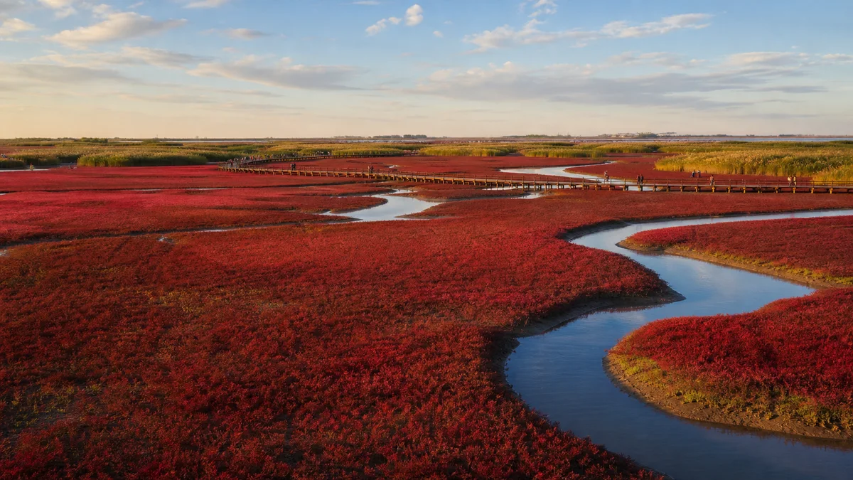
5A View location, maps and nearby scenic areasAt the first boardwalk, look down before you look towards the horizon. The red is not sand, paint or a carpet laid for visitors. It is a low, living saltmarsh plant community, each stem rooted in saline mud between water and land.
That small correction changes the whole visit. Red Beach Scenic Corridor is not a beach in the resort sense. It is a managed viewing route through part of the Liaohe Delta near Panjin, where red saltmarsh, tidal creeks, exposed mud, reed beds, rice fields and human infrastructure meet. The famous colour is one seasonal layer in a much larger wetland system.
Read the landscape from near to far: first inspect individual red stems beside the boardwalk; next follow a creek across the mud; then find the boundary between red saltmarsh and taller reeds; finally look inland for fields, roads, pumps or distant industrial structures. This is a delta used by plants, birds and people—not an empty red canvas.
The “red beach” is living tissue
Scientific studies of the Liaohe Delta commonly identify the dominant red saltmarsh plant here as Suaeda salsa, a salt-tolerant annual in the amaranth family. A careful Chinese name is 盐地碱蓬 (yandijianpeng), while travel descriptions often shorten it to 碱蓬 (jianpeng). Common names and related Suaeda species can be simplified in popular material, so the scientific name is the clearer anchor.
The plant occupies ground that challenges many competitors: saline soil, periodic inundation and changing moisture. Its fleshy leaves and stems sit close to the mud. As plants develop, pigments and the appearance of the canopy change; thousands of individuals together create the wide red patches seen from elevated walks.
Do not imagine an unbroken field. Channels, bare mud, water, green or brown plants and damaged patches interrupt the colour. That mosaic is not a flaw in the attraction. It shows that you are looking at habitat rather than fabric.
The 5A scenic-area profile marks the ticketed corridor. Its visitor boundary should not be confused with every part of the Liaohe Delta or nearby protected wetland.
A delta written in bands
The Liaohe River reaches the low coastal plain through shifting channels and deposits sediment before entering the Bohai Sea. On such flat land, a small difference in elevation or water level can separate several ecological zones. The result is best read in bands rather than as one “beach.”
Closest to active water may be a tidal creek or exposed mudflat, alternately wet and dry. Low saltmarsh vegetation occupies another level. Farther inland, extensive stands of common reed (Phragmites australis) rise much higher, turning wind into visible waves. Freshwater channels, ditches and ponds cut across the sequence. Beyond them can be rice paddies, aquaculture water, roads and settlements.
Mudflats may look empty from a moving shuttle, yet they hold invertebrate food for birds and exchange water, nutrients and sediment with the creeks. Reed beds provide cover and breeding habitat for different species. The red plant is the visual signature, not the wetland’s only important organism.
At a junction in the boardwalk, compare height as well as colour. Red saltmarsh stays low enough to reveal the shape of water channels; reed beds hide the ground and emphasize wind. Together they show how a few centimetres of terrain and a change in salinity can reorganize a landscape.
Colour follows season, water and salt
Promotional images often suggest that one “best red period” can be circled years in advance. Plants do not follow a tourism calendar so neatly. The canopy commonly becomes more strongly coloured as the growing season advances, but the timing, intensity and area differ between years and even between nearby plots.
Several factors interact: seed germination, plant density, temperature, sunshine, rainfall, soil salinity, tidal or managed flooding, storm damage and the plant’s stage of growth. Water on the mud can deepen a reflection or hide low stems. Cloud can mute colour; low sunlight can make the same patch glow. A photograph dated last year is evidence of last year, not a promise for this week.
Before a long trip, look for recent, dated images from the scenic-area operator or Panjin tourism authorities. Ask which boardwalks currently have strong colour and which are open. Once there, resist scoring the wetland against an edited postcard. Rust, scarlet, burgundy, green and bare mud can all belong to a functioning seasonal landscape.
This wetland exists because water does not stay in one place. Tides push through channels; river discharge and rain alter freshwater input; evaporation concentrates salts; ditches, gates and other management structures redistribute water. The visible shoreline therefore moves on several timescales.
A high water level may fill creeks and bring reflections close to a platform, while another condition exposes more feeding mud. Neither guarantees better wildlife. Birds respond to water depth, food and disturbance, and the saltmarsh plants respond to how long and how often their roots are flooded. Too little or too much water can both change vegetation.
Tourism pages sometimes publish tide or “best viewing” information. Treat it as dated operational guidance, not a fixed natural law. Weather and water management can complicate an astronomical tide table, and a given platform may face an interior channel rather than open sea. Check the same-day notice and stay behind closures even if the mud looks firm.
Never step from the boardwalk onto exposed flats. Delta mud can be soft, tidal channels can refill, and footprints damage stems and compact the substrate long after the visitor has moved on.
Birds: observe habitat before chasing names
The wider Liaohe estuary wetlands lie on the East Asian–Australasian Flyway, used by migratory waterbirds moving between northern breeding grounds and southern non-breeding areas. Mudflats offer feeding space; shallow water, reeds and saltmarsh support different groups. The scenic corridor is one viewing window into that regional system, not the whole bird habitat.
You may encounter gulls, egrets, herons, ducks, geese or shorebirds depending on season and water conditions. The broader region is associated with highly valued species including the red-crowned crane and Saunders’s gull, but their presence at your platform is never assured. Avoid turning a conservation headline into a sighting guarantee.
Start with behaviour. Is a bird probing mud, resting on an exposed bank, flying low along a creek or disappearing into reeds? A compact binocular is more useful than a checklist shouted across the platform. If birds repeatedly raise their heads, call, bunch together or move away as people approach, give them more distance.
Do not play recorded calls, feed wildlife or launch a drone. Aerial disturbance can push feeding or resting birds to spend energy unnecessarily, and protected-area rules may extend beyond what a casual visitor can see on a map.
A protected wetland inside a working landscape
It is easy to frame Red Beach as nature untouched by people. The view itself disproves that story. Panjin’s delta also supports rice cultivation, reed use, aquaculture, roads, settlements and the Liaohe oilfield economy. Pumps, well structures or service roads may appear beyond a supposedly pure panorama.
These uses have provided livelihoods and shaped the modern city. They have also altered water flow, fragmented habitat and created pollution or disturbance risks. Wetland restoration and regulation can improve conditions, yet decisions about water, land and access still distribute costs between conservation, farming, industry and tourism.
The ticketed corridor adds another human use. Roads and boardwalks concentrate visitors and make a fragile saltmarsh visible without requiring everyone to cross it. At the same time, construction, traffic, noise, litter and demand for photogenic water levels create their own pressures. Good management is therefore not the absence of people; it is the difficult work of limiting where, when and how different activities occur.
Look inland at rice paddies when they are visible. Panjin’s celebrated wetland and its agricultural identity are not separate postcards. They share a flat delta and depend on managed water, though their preferred salinity and timing differ.
Why the boardwalk matters
A wooden walkway can feel like a minor visitor convenience. Here it is part of the conservation bargain. It spreads weight above wet ground, directs people to robust viewing edges and makes clear where access ends. It also edits the view: every platform is a chosen angle, not a neutral survey of the whole marsh.
Stay inside the railing even when someone else’s footprints appear below. One shortcut creates a visual invitation for the next visitor, widens into a path and fragments the low vegetation. Do not pick a red stem as a souvenir. Annual plants still need to complete their life cycle and contribute seed.
Quiet conduct improves both conservation and observation. Keep food and packaging secured in the wind, take all waste out, and avoid blocking narrow sections with tripods. If a segment is closed, it may reflect water, maintenance, fire risk, bird activity or habitat recovery. A closed platform is not an invitation to find an unofficial angle.
Build a route that fits the day
The attraction is a linear scenic corridor with multiple boardwalk and viewpoint clusters rather than one circular trail. Named stops, entry arrangements and internal transport can change, so first photograph the current map and ask which points are open and where the final return service departs.
Choose one of two practical patterns:
- Short route: select one strong saltmarsh boardwalk and one contrasting stop with reeds, open water or rice fields. Spend longer at each rather than collecting platform names. This suits limited mobility, harsh sun or a tight schedule.
- Long route: link several open clusters from red saltmarsh through channels and reed or agricultural views. Allow most of a day, carry food and water within current rules, and build in a generous return margin. Transfers and queues can take longer than the map suggests.
Begin with a close, low view of the plant, then seek elevation to understand the mosaic. Finish at a quieter outer platform if current transport makes that safe. Do not travel to a distant stop on the assumption that a shuttle, gate or boardwalk will remain open until a remembered time; confirm the last practical connection that day.
Bird and landscape photography without damage
For the saltmarsh, use a wide or normal lens to include a creek. Water breaks the red into shapes and proves that this is wetland, not a flat field. From an elevated platform, a moderate telephoto can compress red plants, silver channels and tan reeds into distinct bands. Include a boardwalk or a person only when you need scale, and do not ask anyone to climb over the rail for a “clean” frame.
For birds, a long lens is both a creative tool and an ethical distance. Brace it on the railing without blocking passage, use a fast shutter in coastal wind and accept atmospheric haze. A record shot made without flushing a bird is better than a sharp close-up produced by disturbance.
Polarizing filters can reduce glare but may remove the reflected light that gives water its structure. Exposure also matters: intense red is easy to oversaturate. Check the histogram, preserve texture in the plants and do not confuse heavy editing with ecological truth.
Drones are not a substitute for a viewing tower. Do not launch one. Besides site rules and aviation concerns, the wetland’s value to birds makes low aerial intrusion especially inappropriate.
Sun, insects, tides and access limits
The corridor offers little shade in exposed sections. Bring sun protection, drinking water and a layer that will not flap loose in strong wind. Mosquitoes and other biting insects can be active near reeds and still water; use repellent and keep screens closed when transport stops. After rain, wooden surfaces and steps can be slippery.
Boardwalks make wetland viewing possible for many visitors but do not make every route fully accessible. Long distances, ramps, thresholds, narrow passing points and shuttle boarding can remain difficult. Wheelchair users and families with strollers should ask which open cluster has the shortest step-free connection and an accessible return option that day.
Do not rely on a generic tide table for personal safety. Stay on the authorised structure, follow evacuation or weather instructions and leave exposed platforms when staff close them for wind, lightning or water conditions. In fog or driving rain, distant red fields can disappear entirely; treat that as weather, not a problem to solve by crossing barriers.
Leave the red where it grows
Before departing, look again at one stem close to the walkway. The landscape’s power comes from repetition: many small plants responding to salt, water and season until the delta seems to change colour. Remove the living detail and “Red Beach” becomes only a brand.
The deeper view includes more than red. Mud feeds birds. Reeds slow the wind. Channels carry sediment and water. Farms and oil infrastructure reveal a worked delta. Boardwalks bring attention and income while drawing a hard line around the visitor’s footprint.
Let your last image hold all of those layers if possible. A wetland is not successful because it matches one brilliant postcard for a few weeks. It matters because living processes continue after the colour fades and after the final shuttle leaves.
The LoreLens app can help distinguish saltmarsh plants, tidal channels, reed beds and the working delta while you follow the boardwalk.
Location profile
Where it is

Frequently asked questions
Why is Panjin Red Beach red?
The colour comes from dense salt-tolerant plants, not red sand or an artificial surface. Scientific work on the Liaohe Delta commonly identifies the dominant red saltmarsh plant as Suaeda salsa, known in Chinese as yandijianpeng and often shortened in tourism material to jianpeng.
When is the best time to see the deepest red colour?
There is no guaranteed date. Colour commonly develops through the growing season, but its strength and extent vary with plant growth, salinity, flooding, temperature, rainfall, storms and recent management. Check dated photographs and the scenic area's current notice before travelling.
How long should I spend at Red Beach Scenic Corridor?
A short visit can focus on one or two open boardwalk clusters, while a broad route linking saltmarsh, reed and rice-field views can take most of a day. The corridor is linear and transfers add time, so confirm the day's open points and transport before choosing a route.
Can visitors walk onto the red plants or fly a drone?
Stay on authorised boardwalks and viewing areas: trampling breaks plants, compacts mud and widens informal paths. Do not launch a drone; low-flying aircraft can disturb birds and may breach scenic-area or protected-wetland rules. Use a long lens from the designated route instead.