Liaoning · Dalian
Jinshitan: Reading Dalian's Coast in Layers
Trace bedding through a sea cliff, watch waves test its fractures, and discover why Jinshitan is a dispersed resort and geological coast rather than a single beach.
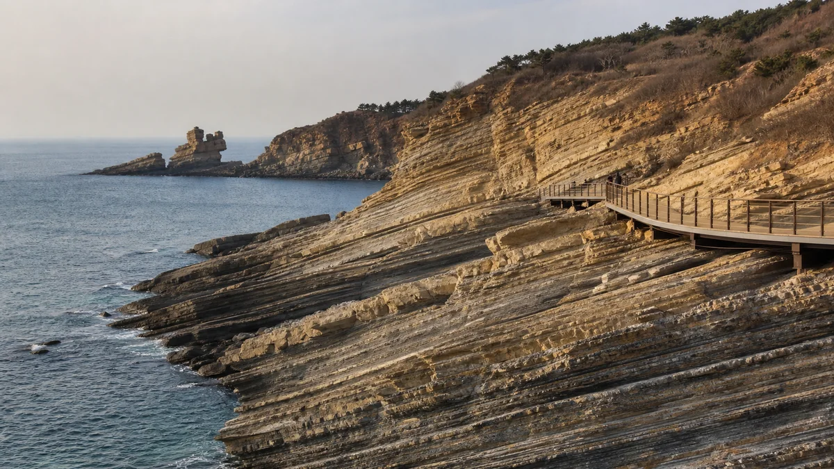
5A View location, maps and nearby scenic areasStop beside an exposed cliff and choose one pale or dark band. Follow it with your eyes until it tilts, breaks at a joint or disappears behind the next headland. Then look lower: waves strike the same weaknesses, loose grains rattle in the wash, and spray reaches farther than a calm photograph suggests.
That simple exercise explains Jinshitan better than the English nickname “Golden Pebble Beach.” This is not one uninterrupted beach. It is a broad, dispersed resort district on Dalian’s outer coast, containing a protected geological shoreline, a bathing coast, museums, leisure facilities and landscaped attractions. The most important decision is therefore not “How long should I stay on the beach?” but “Which Jinshitan am I visiting today?”
Read the coast in this order: identify the rock layers; find fractures cutting across them; watch where waves attack the cliff foot; then compare the scientific evidence with the animal or human name on the sign. Bedrock, erosion and imagination are three different layers of the visit.
One name, several separate destinations
Begin with a map, not a ticket bundle. The coastal national geopark on the eastern shore is the principal place for sea cliffs, erosion forms and geological interpretation. The resort also includes the Golden Coast beach area and a changing collection of cultural, sporting and entertainment venues. They are related by the Jinshitan name, but they are not one continuous walking circuit.
This spatial distinction matters. A metro or road arrival in the resort does not place you automatically at every geological viewpoint. Likewise, buying access to one attraction may not cover another. Internal shuttles, walking links, admissions and open sectors can change by season or maintenance needs. Use the official map and current notices to build the day around one priority rather than collecting place names.
The Jinshitan 5A scenic-area profile gives the mapped location. Treat that pin as an orientation point for the wider district, not a promise that every cliff, beach and venue begins there.
The ancient record is in the strata, not the slogan
Interpretation at Jinshitan often speaks of rocks hundreds of millions of years old. The careful version is more interesting. Research on the geoheritage identifies standard Chinese Sinian strata, a historical Chinese term broadly associated here with the late Precambrian record, together with Cambrian strata. On the modern international timescale, the Ediacaran Period spans about 635–539 million years ago, followed by the Cambrian, about 539–485 million years ago. A particular exposure represents only part of that interval, and local formation boundaries require specialist mapping.
Those numbers date the deposition and later lithification of sediment—not “Jinshitan” as a resort, and not the present shape of a named sea stack. Cliffs, caves and isolated rocks are much younger landforms continually revised by the sea.
To read the sedimentary record, compare rather than touch. Are beds thin like stacked pages or thick like slabs? Do neighbouring layers weather into ledges and grooves? Does a surface carry a repeated texture rather than a random break? The site is known for sedimentary structures, including ancient desiccation-crack patterns, and for fossil evidence such as trilobites in appropriate Cambrian rocks. A pattern that resembles a shell is not automatically a fossil; leave identification to signage or a trained interpreter, and never extract a sample.
How a layered shore becomes a sculpture coast
Waves do not carve rock as if using a chisel. They exploit differences already present. Water and compressed air enter joints; sand and pebbles abrade exposed surfaces; salt crystallisation and freeze–thaw weathering can loosen grains above the direct wave zone. Softer or more fractured beds retreat faster than stronger neighbouring beds.
At the foot of a cliff, repeated attack may cut a notch. As the overhang becomes unstable, pieces fall and the cliff line retreats, leaving or enlarging a wave-cut surface. Along a headland, a weakness can open into a cave; continued erosion may produce an arch, a stack and eventually a lower remnant. This is a process model, not a compulsory sequence visible at every stop.
Watch for fresh angular debris below a face, darker wet zones, undercut rock and blocks separated by open cracks. They are evidence that the “sculpture park” is unfinished—and reasons to obey barriers. A landform may survive for generations and still change during one storm.
See the rock before the animal
Official visitor maps group the geoheritage into named areas commonly translated as Rose Garden, Dinosaur Garden, Nanxiu Garden, Aotan Garden and Jinshi Garden. Current public access may concentrate on only some of them. Within those areas, popular names compare outlines with a dinosaur leaning to sea, a human profile, a bird or another familiar figure.
Use those names as memory aids, not scientific diagnoses. At a “dinosaur” form, first ask which beds dip through the silhouette and which fracture separates it from the cliff. At the so-called Beethoven profile, notice how the recognizable face depends on one viewing angle. Move several steps—where permitted—and the likeness weakens while the geological structure remains.
The celebrated “Turtleback Stone” is better approached through process. Its polygonal pattern is interpreted as a sedimentary desiccation-crack structure: wet sediment contracted as it dried, cracks formed, and later material helped preserve the pattern through burial and lithification. “Turtleback” describes its appearance. It does not mean a turtle produced the rock, nor should claims about uniqueness or world ranking replace observation of the structure itself.
From a working shore to a national resort
Long before the modern brand, this was a coast used by nearby communities for fishing, gathering and shore access. The sea was workplace and route as well as scenery. That history can be hard to see amid promenades and themed attractions, yet boats, harbour infrastructure and seafood economies connect the resort to a lived coast rather than an empty natural stage.
The decisive modern turn came in 1992, when the State Council approved Jinshitan as a national tourist resort. Roads, accommodation, recreation and landscaped public space extended tourism from the shore inland. Academic work on Jinshitan’s tourism urbanisation describes both stronger infrastructure and a reorganisation of land, housing and access—not simply a prettier beach.
The geological layer of that development became formal later. Local-government records state that Dalian Coastal National Geopark was approved by the former Ministry of Land and Resources in September 2005, and the Jinshitan coastal park opened to visitors on 1 May 2008. Jinshitan is also recognised as a national 5A tourist attraction. These labels overlap, but they answer different questions: resort status concerns a wider tourism district; geopark status centres geoheritage and interpretation; 5A is a tourism quality classification.
Access and protection pull in opposite directions
Boardwalks, signs and managed transport make a fragile coast understandable to more people. They can also concentrate trampling, waste and demand for ever closer viewpoints. New facilities bring jobs and easier access, while hard coastal engineering or poorly placed construction can interrupt natural processes and diminish the very outcrops visitors came to see.
Good management therefore includes limits: closed spurs, barriers below unstable cliffs, no collecting, and routes that do not reach every photogenic rock. These can feel inconvenient, especially after a long journey. They are part of the attraction rather than a failure of it. Fossils and sedimentary structures lose scientific context when removed; a chipped “souvenir” cannot be put back into its layer.
There is a human balance too. Protecting a coast should not turn nearby fishing history into decoration or erase local access without discussion. Tourism revenue, community livelihoods, shoreline ecology and scientific conservation do not automatically align. Jinshitan is most honest when visitors can see both the benefits of public access and the restraint required to keep access possible.
Choose a short reading or a long transect
For a shorter visit, make the geological coast the only major goal. Start with the visitor centre or geological museum if it is operating, photograph the current route map, then walk one core cluster slowly. Spend time on three observations—bedding, a cross-cutting fracture and an erosion form—before returning by the designated path. This produces more understanding than rushing past every named silhouette.
For a longer visit, extend along additional open geological clusters, using official transport where required, and add one contrasting part of the resort: perhaps a public beach section, museum or landscaped venue. Keep that second experience conceptually separate. Swimming conditions do not describe the cliff path, and an open resort venue does not prove that a tide-exposed geological spur is accessible.
Do not construct a route from an old blog’s sequence alone. Ask the operator which park entrances, one-way sections, return transport and shoreline links are functioning that day. If the full coast is unavailable, a shorter interpreted section remains a complete visit rather than a failed version of the long one.
The route changes with tide, wind and maintenance
The sea controls more than scenery. A falling tide may expose platforms and reveal the cliff foot; a rising tide can remove the same margin quickly. Predicted tide height is only one input. Atmospheric pressure, onshore wind, swell and recent storms can raise water levels or send waves across apparently dry rock. Rain makes steps and polished surfaces slippery, while fog can reduce both visibility and orientation.
Check a reliable local tide table and marine forecast, then compare them with the park’s current access notice. Turn back at gates or staff instructions even if your app says “low tide.” Never enter a cave, climb a stack, cross a wet barrier or stand below a fresh rockfall scar. Keep children close and leave the waterline early rather than racing an incoming tide.
The easiest promenade and indoor interpretation spaces may suit many wheelchair users or visitors with limited stamina, but the geological shore can include steps, gradients, narrow boardwalks and exposed sections. Accessible segments, shuttle boarding and toilets change with operations. Ask for a step-free route at the current entrance instead of assuming the entire “scenic area” shares one accessibility standard.
Photograph evidence, then return to the layer
For scale, include a person on the permitted path, a railing or a known-width boardwalk—never send someone below a cliff for the photograph. A moderate telephoto lens isolates bedding and joints; a wider frame shows how the structure relates to the headland and sea. Side light often makes textures legible, while overcast weather can control glare on wet rock. Neither light nor visibility is guaranteed.
Build a three-frame sequence: the whole headland, the erosion form, then the sedimentary detail that helps explain it. Record the sign name separately so a folk nickname does not become a geological claim in your caption. Drones, tripods and access beyond railings may be restricted; confirm current rules on site.
Before leaving, return to the first band you followed through the cliff. You can now see three timescales in it: ancient sediment accumulating in a vanished environment, waves and weather remaking the exposed coast, and a few decades of resort development deciding how people reach it. Jinshitan’s best view is not one animal-shaped rock. It is the moment those timescales occupy the same frame.
The LoreLens app helps distinguish bedding, joints and erosion forms on site, then keeps popular rock names separate from geological interpretation.
Location profile
Where it is

Frequently asked questions
Is Jinshitan just one beach?
No. Jinshitan is a large, dispersed coastal resort area in Dalian. Its geological park, bathing shore, museums, leisure venues and other attractions occupy separate clusters, sometimes with their own admission and operating arrangements. Decide which cluster matters most before setting out.
How old are the rocks at Jinshitan?
The protected coast exposes sedimentary strata assigned mainly to the Ediacaran and Cambrian intervals—roughly 635 to 485 million years ago in the modern international timescale, although individual outcrops cover narrower ranges. Those dates describe when sediments accumulated, not the age of today's cliffs, sea caves or tourist area.
How much time should I allow for Jinshitan?
A focused visit can use a few hours for interpretation and one core coastal section; a longer day can add more geological clusters or a separate beach, museum or resort stop. Walking pace, tides, weather, seasonal closures and internal transport all change the practical plan, so confirm the current route before arrival.
When is the coastal walk safest?
Choose a calm forecast, check the operator's current access notices and consult a reliable local tide and marine-weather source. A predicted low tide does not guarantee an open or dry route, and wind, swell, rain, rockfall controls or maintenance may close sections. Stay on the designated path and turn back when instructed.