Xinjiang · Ili
Nalati Grassland: Two Meadows, One Pastoral Ladder
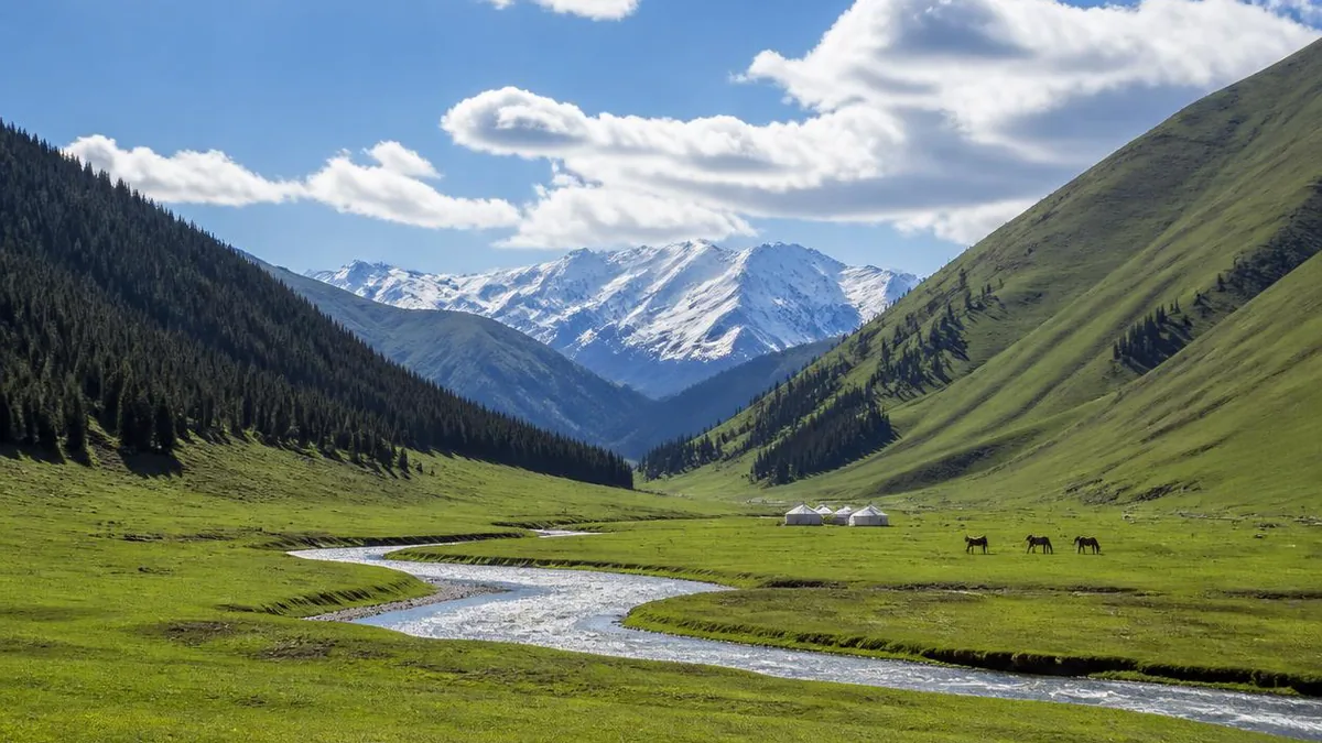
A valley pasture and a sky pasture separated by a saddle, two sun-names from two different language families, and a Kazakh herding calendar that the shuttle map accidentally reproduces.
5A View location, maps and nearby scenic areasTwo shuttle routes leave the Nalati visitor centre. One is labelled the valley grassland, the other the sky grassland, and most itineraries present the choice as a matter of budget and time. It is not. It is a choice between two rungs of the same mountain, and the rungs are not interchangeable.
Local advice compresses the whole thing into six words: valley on a wet day, sky on a clear one. That is good advice, but it hides the more interesting fact. The two grasslands were two seasons of pasture long before they were two ticket options — spring and autumn down in the river valley, summer up on the high open ground. The road that crosses between them crosses a saddle. Everything worth understanding here is arranged along that vertical line.
Two names for the sun, in two language families
The grassland has two names, and both of them mean roughly the same thing in two unrelated languages.
Nalati is generally read as Mongolian. Comparative treatments point to a form like naratai, or naratu in the Oirat dialect, built on naran, sun, and meaning something close to sunlit or having sun. The tourist gloss — the first place to see the sun — is an expansion that later encyclopedia entries copied from each other until it hardened.
Kunes, the valley and river the grassland occupies, appears in Chinese as Gongnaisi and is popularly explained as Mongolian for sun slope. Etymological work instead traces it to an Old Turkic word along the lines of küneš, sun or sunny place, with cognates in modern Turkish and Crimean Tatar. Chinese place-name compilations describe Xinyuan County’s local Kazakh name for the river in the same sense: sunward.
So the likeliest reading is a Turkic substrate name for the valley and a Mongolian name for the meadow, arriving centuries apart and converging on the same idea. That is a more honest story than the legend usually told, in which Genghis Khan’s troops crossed a pass out of snow, found flowers and sunlight, and shouted the name. Versions of that tale disagree about the season and about whether the light was noon or sunset, which is what folk etymologies do.
A river that runs west and never reaches a sea
The Kunes river is described locally as a river that runs backwards, meaning west, and Kazakh herders call it the mother river. It rises near the pass country on the boundary between Xinyuan and Hejing counties, crosses the whole length of Xinyuan, and joins the Tekes river in Gongliu.
That junction matters. Chinese hydrology conventionally says the Ili river begins where the Tekes and the Kunes meet — some accounts wait until the Kash river joins as well. From there the Ili runs west into Kazakhstan and ends in Lake Balkhash. Length figures for the Kunes itself vary widely between sources, from around 250 kilometres to over 300; the ones that circulate most freely come from commercial content sites, so hold them loosely.
The consequence is climatic. The Ili valley opens west, which is how moisture reaches this far into the interior at all, and Nalati sits at the eastern, closed end of that funnel. The area’s own material calls the climate continental semi-arid, then notes that a temperature inversion moderates both summer heat and winter cold. A grassland this lush inside an arid region is a product of that geometry.
The slope is a stack of belts, and the road crosses four of them
Nalati is often introduced as a subalpine meadow, and that is accurate but incomplete. What you actually drive through is a sequence.
Published descriptions of the area run, from the top down: permanent snow and ice on the ridge, then dark conifer forest below the snowline, then a silver band of birch, then unbroken meadow down to the valley floor. The forest park inside the area is given as spanning roughly 1,600 to 2,800 metres, with annual precipitation quoted at 800 to 1,200 millimetres — a genuinely wet figure for Xinjiang, and the reason the tree band exists.
The dominant tree is Schrenk spruce, Picea schrenkiana. The meadow beneath and above it is described as an iris-dominated community, with Phlomis, gentians, sedges, wheatgrass, fescue, wild strawberry and thyme in the sward, and snow lotus higher up.
Figures for the area itself are inconsistent, as usual: average elevation 1,800 metres, planned area 1,848 square kilometres, the Nalati ridge to the southeast 4,275 metres. Read the belts rather than the numbers. On the drive up you can watch the birch drop out, and that line is the top of the wet band.
Tianjietai is a saddle, and the saddle is the point
The first stop on the sky-grassland circuit is Tianjietai, and it is the single most informative place in the scenic area — not because of the view, though the view is the one they photograph, but because of the landform.
Tianjietai is a saddle: high ground on both sides, a dip in the middle. That is why the road goes over it and not around. Stand in the dip and the asymmetry is immediate — forest on one flank, open grass on the other, the same rock at the same elevation. It is the same water-budget line that governs the whole northern Tianshan: shaded slopes hold snow longer and evaporate less, so a shade-tolerant spruce seedling survives its first summers there and cooks on the facing slope.
The saddle also does the work the brochures assign to it: it is the divide between the valley grassland below and the sky grassland above. From the dip you can look back down the whole river valley and forward onto the high meadow, which is the only place the two-tier structure is visible at once.
One practical note. Accounts of the cable car describe it lifting from a lower station in the low 1,000s of metres to Tianjietai above 2,000 — roughly a kilometre of vertical. Sources measure from different points, so treat any elevation pair as approximate.
Why there is a flat meadow above 2,000 metres
The sky grassland raises an obvious question that almost nothing published bothers to answer: why is there a broad, gently graded meadow up there at all, instead of the ridge-and-gully country you would expect?
The answer given in Chinese descriptions is that this is a mid-mountain grassland developed on old Tertiary proluvial deposits — fan material shed off the ranges long ago and since lifted. The flat is inherited. It is an old surface carried up, not a modern floodplain, which is why it can be both high and level.
That inheritance is what makes the pasture possible. A flat surface at this elevation collects and holds water instead of shedding it, and the soil beneath it is subalpine meadow soil: high in organic matter, loose, permeable, slow to release nutrients because it is cold for much of the year. Descriptions of this soil type across the Tianshan and Altai put it broadly between 1,800 and 3,300 metres, with surface organic content that can exceed ten percent and a tendency to increase with elevation.
Cold, wet, deep, slow. That combination grows short dense turf with a great many species in it and very little woody competition — the same recipe that operates on the Kalajun platform west of here, arrived at by a different geological route.
The flowers are a compressed calendar, not a display
Nalati sells flowers, and it delivers them, but not in the way the photographs imply.
The constraint is the growing season. At this elevation the ground is frozen for a large part of the year, so plants germinate, grow, flower and set seed inside a few weeks. Species that would spread their flowering across a long temperate spring are forced to overlap. That overlap is the flower field. It is also why alpine and subalpine flowers tend to be large and vividly coloured relative to the plant: with few pollinators and a short window, competition for insect attention is intense.
The sequence in the Ili valley is well documented and earlier than most visitors assume. White crocus opens on the sky meadow from early spring, wild tulip from mid-March into May, forget-me-not and snow primrose through May and June, marsh marigold May to June on damp ground. Lilies come around late June. Snow lotus is a July and August plant at high elevation.
Read the durations, though. The regional flowering calendars give most of these species a window of only about seven to twenty days each. The area’s own material describes June to September as the season and notes that the herds move in after June. A flower field is a sum, and you are betting on the overlap.
Two circuits, two rungs of one working ladder
Here is the part the ticket structure quietly encodes. The valley grassland is described as the spring and autumn pasture; the sky grassland as the summer pasture. The two shuttle loops are two seasons of a Kazakh herding year.
Vertical transhumance in the Tianshan works by matching animals to whichever elevation band has grass. Families overwinter low in sheltered ground, use spring and autumn pasture on the mid slopes, and take stock to the high meadow for roughly three months of summer. The move up comes around June and the move back before the September cold. A herder’s phrase for it is worth carrying: going up in summer, people chase the snow; coming down in winter, the snow chases the people.
This is production, not pageantry. Xinyuan County reports a total grassland area on the order of 5,000 square kilometres and livestock in the range of a million head, with 530,000 mu closed to grazing outright and 6.249 million mu under stocking-balance contracts. The county forestry and grassland bureau’s remit explicitly includes stopping overgrazing and stopping herders from moving off-schedule. One reported household in Nalati town held 1,626 mu of pasture and cut hay on 725 of them, most of it for sale.
So when a yurt sells you tea, you are inside a household budget that turns on how much weight a sheep gains between June and September. Ask before photographing animals or people at close range.
The Wusun were here before the name was
Long before either sun-name, this valley belonged to the Wusun, a nomadic power of the second and first centuries BCE and the reason Han-dynasty diplomacy reached the Ili at all.
Zhang Qian’s missions to the Western Regions were aimed at an anti-Xiongnu alliance, and two Han princesses — the ones Chinese sources name Xijun and Jieyou — were married into the Wusun house. Over 200 Wusun burial mounds are counted across this grassland. One of them, described as about 46 metres across and 6.5 metres high, is thought to be the tomb of the Wusun king Liejiaomi.
Note the verb. It is thought to be, not confirmed as. Mound attribution without excavation and inscription is inference, and this one should be read as a strong local tradition rather than a settled identification. The same caution applies to the frequent claim that the Wusun are the principal ancestral stock of today’s Kazakhs; it is repeated in official material, but descent claims across two thousand years of steppe history are not the kind of thing a mound settles.
What is not in doubt is the continuity of use. An old geographical text describes this as deer country, nicknamed the deer pen for its springs and its herds. The animals have changed; the reason for being here has not.
What it is designated as, what it is not, and how to plan two days
Be precise about the labels, because there is an upgrade in circulation. Nalati is not part of the Xinjiang Tianshan World Heritage property, whose four components are Tomur, Kalajun-Kuerdening, Bayinbuluke and Bogda. The name reappears in heritage material only because Kuerdening, half of one component, lies on the northern slope of the Nalati mountains in Gongliu — a different valley in a different county.
What Nalati genuinely holds is Chinese designations: national 4A in December 2005, national 5A given as December 2010 in the county government’s own chronology and as 2011 elsewhere, a national eco-tourism demonstration area in 2015, and recognition as a national-level tourist resort in December 2020. Its master plan states a maximum daily capacity above 350,000 visits, which tells you what kind of place this is designed to be at peak.
Practically: plan two days and take one circuit per day. Give the sky grassland to the clearer forecast. Everything else — fares, circuit stops, cable-car operation, the number of days a ticket stays valid, whether horses can be hired at a given stop — moves between seasons and sources, so confirm it at the gate rather than from any itinerary, including this one.
Stand on the saddle at first light and look both ways
If you take one thing from Nalati, take the saddle.
Get to Tianjietai early, before the shuttles fill. Look down first: the Kunes river working west through spring-and-autumn ground, on its way to a junction that will make it the Ili and then carry it out of China into a lake with no outlet. Then turn and look up: an old fan surface, lifted, flattened, holding cold water in deep dark soil, growing three months of grass that a household will spend the rest of the year living off.
The two views are the two halves of one system, and the dip you are standing in is the hinge. Nalati is famous for being beautiful, which you will have established within a minute of arriving. What takes longer to see is that the beautiful part is a working ladder, and that both of its names mean sun.
Location profile
Where it is

Frequently asked questions
What is the difference between Nalati's sky grassland and valley grassland?
They are two different rungs of the same mountain, and historically two different seasons of pasture. The valley grassland follows the Kunes river through the lower part of the area and is described in local material as spring and autumn ground; the sky grassland is the high open meadow above it, usually given as roughly 2,000 to 2,200 metres, and is summer pasture. The two shuttle circuits are separate loops with separate fares, and the boundary between them is a saddle called Tianjietai. Local advice is blunt and useful: valley on a wet day, sky on a clear one, because the sky meadow is worth nothing in cloud. Fares, circuit stops, cable-car operation and whether the ticket is valid for one day or two vary by season and source, so confirm at the gate.
Does Nalati really mean the first place to see the sun?
That gloss is an embellishment of something simpler. Comparative work on the name points to a Mongolian form along the lines of naratai or, in Oirat, naratu, meaning roughly having sun or sunlit, from the root naran, sun. The tourist rendering as the first place where the sun appeared is a later expansion. The accompanying story, in which soldiers on Genghis Khan's westward campaign crossed a pass out of snow into flowers and sunlight and shouted the name, is a folk etymology attached to the place rather than evidence for it, and retellings disagree about the season and even whether the light was midday or sunset. Treat it as a story worth telling as a story.
When should I go, and how many days do I need?
June to September is the working window, and the flower peak is earlier than most people expect. Herds move up after June, which is when the pasture looks its fullest. Individual species are brief: the Ili flowering calendars give many of the meadow flowers a run of only about seven to twenty days each, so a flower field is a sum of overlapping species rather than a single reliable event. Two days lets you take one circuit per day and still catch the sky meadow in good light. One day forces you to choose, and if you choose wrong on the weather you lose the reason you came.
Is Nalati part of the Xinjiang Tianshan World Heritage site?
No. That serial property was inscribed in 2013 with four components: Tomur in Wensu, Kalajun-Kuerdening in Tekes and Gongliu, Bayinbuluke in Hejing, and Bogda around Fukang. This scenic area in Xinyuan is not among them. The confusion is understandable, because the name reappears in heritage material: Kuerdening, half of the Kalajun-Kuerdening component, sits in a valley on the northern slope of the Nalati mountains in Gongliu County, which is a different place in a different county. What Nalati itself holds is a stack of Chinese designations, including national 5A status and recognition as a national-level tourist resort in December 2020.
Sources and further reading
Background references for the history and place names in this guide. Opening hours, ticketing and access change often — always confirm with official local information before travelling.