Tianjin · Jizhou Mountains
Mount Pan: Pines, Stone and Imperial Memory
Read Mount Pan from lower water to middle rocks and upper pines, trace its restored Buddhist landscape, and choose a route that fits your time and mobility.
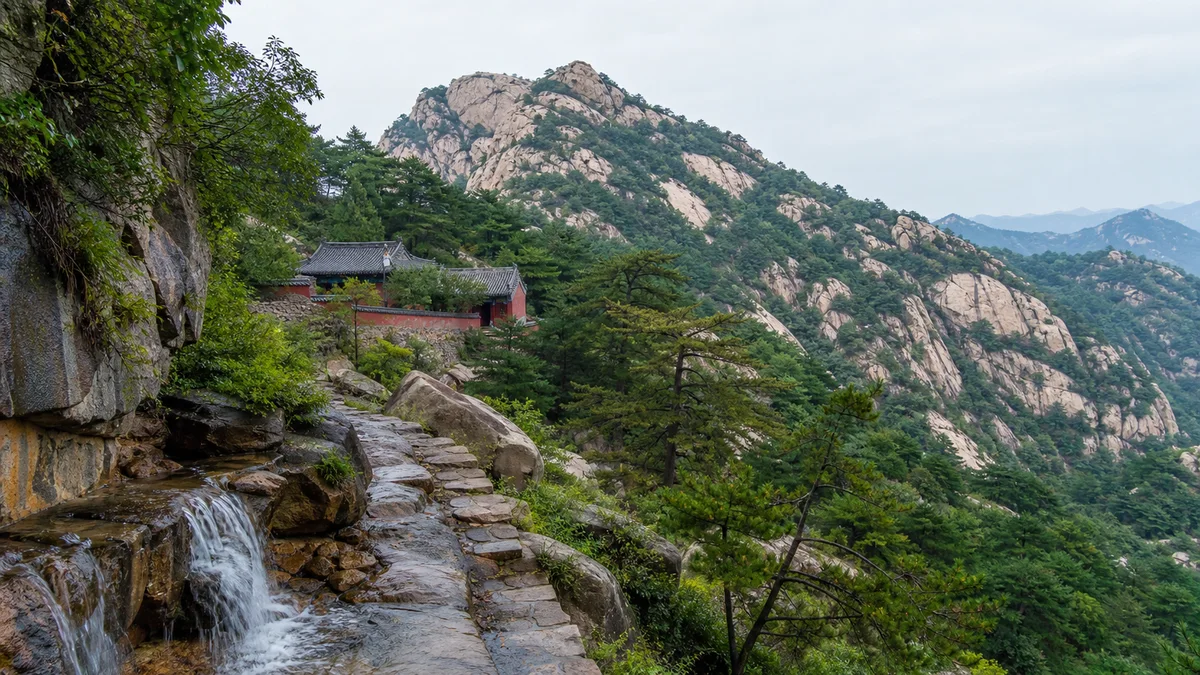
5A View location, maps and nearby scenic areasJust beyond the entrance, pause wherever the path runs beside water and look uphill. The summit is not yet the most useful thing to find. Instead, notice how the mountain changes material: moving water and shaded pools below, pale boulders and temple terraces in the middle, then dark pines gripping the higher ridges.
That sequence is the key to Mount Pan—Panshan in Chinese, pronounced roughly “pahn-shahn.” Its traditional viewing formula is “upper pines, middle rocks, lower water” (shang pan song, zhong pan shi, xia pan shui). It is not a scientific zoning map. It is a compact instruction for seeing one mountain as three different worlds.
A useful orientation: current maps commonly connect the entrance and lower water with Tiancheng Temple, the middle mountain with Wansong Temple, and the upper slopes with Yunzhao Temple and Guayue Peak. Names, one-way sections and transport links can be adjusted, so photograph the map at the gate and confirm what is open before committing to the summit.
Read the mountain in three bands
Mount Pan rises in Tianjin’s northern Jizhou District, among the foothills and ridges east of Beijing. Its highest point, Guayue Peak, is commonly measured at about 864.4 metres above sea level. That is modest beside China’s famous high mountains, but elevation alone does not explain the experience. A visitor repeatedly changes scale—from a stream channel narrow enough to cross in a few steps to rock faces that hide the next terrace, and finally to a ridge where the plain opens beyond the trees.
The old three-part formula makes those changes memorable. “Lower water” asks you to watch channels, pools and seasonal flow. “Middle rocks” directs attention to weathered stone, cliff paths and buildings fitted into ledges. “Upper pines” frames the summit as a realm of wind, silhouette and distance.
Treat the formula as an ideal, not a promise. Water volume changes after rain and through dry seasons; mist can erase the upper view; forest management and modern construction affect what appears in each band. The pleasure is in testing the phrase against the mountain in front of you.
Begin with lower water and Tiancheng Temple
The lower route is where Mount Pan first teaches visitors to slow down. Follow the sound of water rather than rushing towards the steepest stair. In wet periods, small cascades animate the rock; in dry weather, polished channels and rounded basins still reveal where water normally works.
Maps commonly mark Tiancheng Temple in this lower zone. Temple names and foundations on Mount Pan have accumulated histories of founding, rebuilding and renaming, so a standing hall should not automatically be read as untouched ancient fabric. Look for the relationship instead: a courtyard protected by slope, a stupa or stone element rising above a roofline, and an approach that makes water part of the transition from ordinary road to sacred ground.
This was never only scenery. Monks needed water, fuel, food and paths; pilgrims needed places to rest; local craftspeople repaired walls, roofs and steps. The picturesque temple terrace is also evidence of maintenance repeated across generations. If worship or incense is active, give it priority over photography, keep voices low and do not enter closed halls for a better angle.
Middle rocks, Wansong Temple and the work of staying
Higher up, water becomes less visually dominant and the stone takes over. Boulders divide the path; stairs climb around outcrops rather than erasing them. This is the “middle rocks” of the traditional formula, and it is where the mountain’s architecture often feels most negotiated with terrain.
Wansong Temple—the “Temple of Ten Thousand Pines”—is commonly used as a middle-mountain landmark. Accounts connect the site with long Buddhist occupation and with stories about earlier recluses, but individual foundation legends are not equally well documented. What can be read on site is more concrete: retaining walls, thresholds, drainage, reconstructed timberwork and the physical effort required to keep a religious community functioning on a slope.
Pause before the courtyard and look back at the approach. Every slab had to be placed; every roof repair brought material uphill. Monks were not decorative figures in a landscape painting, and porters, masons, carpenters and nearby villagers were not invisible helpers. Their labour turned a difficult mountain into a connected religious route. Modern paving and railings continue that work in a different form.
Upper pines, Yunzhao Temple and Guayue Peak
The upper mountain is usually read through pine trunks, wind and widening gaps between ridges. Yunzhao Temple, whose name suggests a temple “lit by clouds,” is commonly marked near the upper route, while Guayue Peak forms the high goal at roughly 864.4 metres. The precise sequence you can walk may depend on the day’s access controls and which transport sectors are operating.
Do not expect the summit to behave like a viewing platform with a scheduled reveal. Haze from the plain, low cloud, rain or summer humidity can reduce visibility; winter wind or ice can make exposed stone unsafe. On a clear day, use foreground pines to give the distant ridges depth. In mist, reverse the instinct to be disappointed: the nearest branch and temple eave may explain the old landscape-painting tradition better than a broad panorama.
The phrase “upper pines” also describes endurance. Trees root in cracks, bend under wind and frame religious buildings without belonging to them. Avoid stepping beyond barriers or compressing soil around exposed roots for a photograph. The upper landscape is resilient, not indestructible.
Qianlong and a line almost too perfect
Mount Pan’s most famous visitor was the Qianlong Emperor, the eighteenth-century Qing ruler whose long reign combined military power, collecting, travel and an enormous production of imperial writing. Local histories and tourism accounts commonly state that he visited Mount Pan 32 times. The number is widely repeated, though counts can depend on what is classified as a visit or stay.
He did more than admire a view. Imperial patronage added poems, inscriptions and a courtly layer to an already religious mountain. A mountain retreat associated with his visits made Mount Pan part of the Qing imperial travel landscape. That attention brought resources and prestige, but it also taught later visitors to see the mountain through an emperor’s preferences.
The line most often attached to him is:
“If I had known Mount Pan, why go south of the Yangtze?”
It is a brilliant piece of destination advertising: a northern mountain supposedly made the celebrated gardens and scenery of Jiangnan unnecessary. The saying is widely attributed to Qianlong, but it is safer to treat it as the emblem of his attachment unless a source establishes the exact text and occasion. Do not imagine that someone simply overheard a spontaneous remark and preserved it word for word.
Its modern echo is everywhere. The line still frames Mount Pan as a northern answer to southern scenery, and the repeated “32 visits” turns imperial preference into a quality seal. A better response is to ask what the comparison hides: Mount Pan is most interesting not because it replaces Jiangnan, but because water, rock, Buddhism and court culture meet here in their own way.
A sacred landscape rebuilt after loss
Mount Pan’s religious history reaches across many centuries, but the visible site is not a sealed medieval survival. Temples were repaired, enlarged, renamed, damaged and rebuilt under different dynasties and patrons. Warfare, fire and twentieth-century disruption brought severe losses. Later restoration and tourism development returned halls and route continuity to places where little or incomplete fabric remained.
That does not make the experience “fake,” but it changes the question. Separate at least four layers as you walk: natural rock and vegetation; surviving inscriptions, masonry or older foundations; restored or reconstructed religious buildings; and modern visitor systems such as paved stairs, signs and cableways. A single photograph can contain all four.
Buddhist spaces also retain a meaning beyond architectural age. A recently reconstructed hall may still host offerings, caretakers or worship; an old stone fragment can survive outside its original setting. Respect present practice without pretending every beam is ancient. The mountain’s authenticity lies partly in continuity of use and remembrance, and partly in being honest about rupture.
Choose a route, not a badge of honour
Walk the full ascent if you want the old vertical logic to remain intact. Beginning with lower water, passing Tiancheng Temple and the middle mountain, then continuing towards the upper temples and summit lets the three-part formula unfold under your feet. It requires sustained climbing on stone steps and enough time to return safely.
Combine walking with a shuttle or cableway if you want representative sections without the full elevation gain. A practical plan is to preserve one continuous walking band—lower water and a temple approach, or the middle rocks—then use transport for another sector. Current ticket bundles, transfer points and last departures should be checked at the entrance.
Use upper access for a shorter visit when time, heat or mobility makes a long climb unsuitable. Even where transport reaches the upper mountain, expect slopes, thresholds and steps between stations, temples and viewpoints. “Cableway accessible” does not automatically mean step-free.
None of these routes is morally superior. Imperial travellers used attendants; temples depended on supply networks. Choose the version that leaves enough attention for the mountain. Before going up, confirm whether your intended descent is open—especially if different cableways or gates do not share the same schedule.
Photograph weather, stone and distance
Mount Pan rewards photographs that show relationships rather than isolated monuments. In the lower band, place a stream channel or pool in the foreground and let the path lead towards a roof. In the middle band, stand back far enough to show how a wall meets a boulder; the negotiation between building and rock is the subject. Higher up, use one pine trunk or temple eave as a dark frame for the layered ridges.
Soft cloud can be more useful than a blank blue sky because it separates planes and catches around the upper temples. After rain, stone gains colour and reflections, but it also becomes slippery. Never step into a channel, climb a retaining wall or cross a barrier to remove people from the composition.
Be restrained around worship. Ask before closely photographing monks or worshippers, avoid flash in halls, and obey any no-photo signs. A quiet courtyard is not an empty film set. Sometimes the most truthful image is the worn threshold or repaired roof, because it records use rather than pretending the mountain has remained unchanged.
Safety, access and the view on the way down
Stone stairs can be uneven, polished and slick. Wear shoes with grip, carry water, and allow extra descent time: tired legs often find downhill steps harder than the climb. Summer brings heat, humidity and thunderstorms; cold periods can bring wind and ice. Check official notices and a current forecast, and turn back early if thunder, poor visibility or surface conditions worsen.
Visitors with limited mobility should ask for a route described in actual surfaces—distance, stairs, gradients, transfer gaps and accessible toilets—not merely whether a cableway exists. Temple thresholds and older terrain can remain barriers after mechanical transport. A companion and a conservative turnaround point may make the visit more comfortable.
On the descent, test the old formula once more. The summit pines give way to middle stone, then the sound of lower water returns. By now the sequence should feel less like a slogan. It holds religious retreat, imperial taste, manual labour, destruction, reconstruction and today’s managed scenic area in one vertical journey.
Mount Pan does not need to defeat the scenery south of the Yangtze, and it does not need every visible hall to be an ancient original. Its richer claim is quieter: water, rock and pine keep teaching each generation how to assemble a mountain from what survives, what was rebuilt and what the weather allows you to see today.
The LoreLens app can narrate Mount Pan’s temples, inscriptions and landscape layers while you move from lower water towards the upper pines.
Location profile
Where it is

Frequently asked questions
How high is Mount Pan?
The scenic area's highest summit is Guayue Peak, commonly listed at about 864.4 metres above sea level. The mountain feels larger than that figure suggests because the visit climbs through a sequence of watercourses, rock slopes, temples and exposed upper ridges.
Do I need to hike all the way up Mount Pan?
No. A full ascent gives the clearest sense of the mountain's vertical story, but many visitors combine selected walking sections with scenic-area transport or a cableway. Routes and interchange points can change, so confirm the current map and return options before setting out.
Are Mount Pan's cableways always running?
No. Wind, lightning, maintenance, seasonal schedules and crowd control can suspend a cableway or change last boarding times. Check the scenic area's same-day notice and keep a walking or early-return alternative rather than making the descent depend on one service.
Are the temples on Mount Pan all ancient originals?
No. Mount Pan has a long Buddhist and imperial history, but warfare, fire and periods of abandonment caused major losses. Today's landscape mixes surviving stonework and older foundations with restored or reconstructed halls, modern paths and visitor infrastructure.