Shandong · Qingdao
Mount Lao: Where Granite Meets the Yellow Sea
Choose among Jufeng, Taiqing, Yangkou and Beijiushui to read a coastal granite mountain through Daoist practice, shifting weather, tea villages and water-shaped valleys.
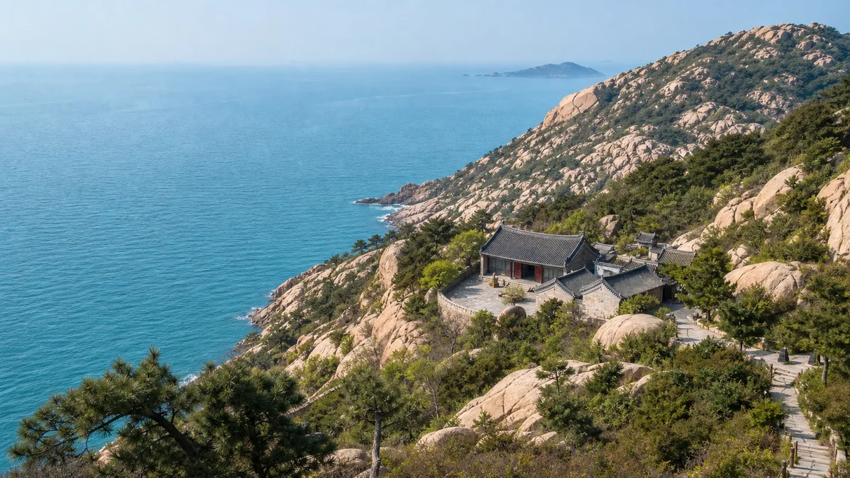
5A View location, maps and nearby scenic areasAt your first open view, trace one pale granite ridge with your eyes until it drops into the Yellow Sea. The rock looks as though it were pushed straight out of the water. In geological time, the order is different: magma cooled deep underground, uplift and erosion exposed it, and the present sea now works on its edge.
That distinction is the key to Mount Lao. This is not one summit followed by one temple and one waterfall. It is a broad mountain-and-coast landscape east of Qingdao, entered through route systems that reveal different relationships among granite, water, religious life and villages.
Treat Mount Lao as four separate day choices: Jufeng for high mountain terrain, Taiqing for Daoist temples beside the southern coast, Yangkou for steep granite and northeastern sea views, and Beijiushui for an inland stream valley. Entrances, sightseeing vehicles and cableways do not form one continuous circuit.
Granite explains the shapes before legend does
Most of the conspicuous rock at Mount Lao is granite, formed when molten rock cooled below the surface during the distant geological past. Later uplift, pressure release, fractures, rain, salt, temperature change and gravity opened joints and rounded exposed blocks. That process produced balanced-looking boulders, vertical cracks, domes and narrow passages.
Look for straight joint lines crossing apparently organic shapes. A “stone gate” or “giant’s profile” may receive a poetic name, but the visible fracture pattern is evidence you can test yourself. Local names and immortality stories are part of cultural history; they are not an alternative mechanism for how the rock formed.
The main summit area, Jufeng, rises to roughly 1,133 metres above sea level. Its drama comes from that elevation standing unusually close to the Yellow Sea, not from competing with China’s highest mountains. Maps may use “Jufeng” for a scenic zone, a ridge route and the main peak in slightly different ways, so do not assume every ticketed path reaches the exact highest point.
One mountain name hides four journeys
Mount Lao is an umbrella scenic area with separated gates and long road transfers. A route map can look compact when the sea and mountains are drawn without travel time. On the ground, switching zones may require returning to a transport hub or making a substantial drive.
Jufeng is the high, exposed choice. Taiqing combines a major Daoist institution with coastal scenery. Yangkou offers sculptural granite, steep passages and sea views from the northeast. Beijiushui follows water and woodland inland. Each can fill the attentive part of a day.
Choose by the experience you want, not by a checklist of famous names. If religious history matters most, start with Taiqing. If a physical mountain day matters most, choose Jufeng. If recent rain has filled the streams and you prefer shade to open ridges, Beijiushui may fit. If steep stairs and tighter rock passages are acceptable, Yangkou gives a different coastal angle.
Jufeng is a weather lesson at 1,000 metres
The Jufeng zone brings you closest to Mount Lao’s high-mountain scale. Sightseeing transport and, when operating, cableway options can remove part of the ascent, but the meaningful sections still involve repeated steps, slopes and exposed walking. A ridge circuit is not the same as stepping out of a lift onto a summit.
As you climb, compare near and distant textures. Close up, granite breaks into grains and jointed slabs; farther away, whole ridges soften into rounded masses above the sea. Cloud may erase the coast in minutes. When visibility returns, Qingdao’s urban edge, islands and the Yellow Sea can appear in layers, but none is guaranteed.
Wind, lightning, ice, rain and heat can make the upper route unsafe. Cableways may stop and paths may close. Carry water and a windproof or waterproof layer, use shoes with grip, and accept an official closure as information about the mountain—not a failure to deliver a promised panorama.
Taiqing Palace is a living institution, not a Han time capsule
The Taiqing route places temple roofs, old trees and granite slopes close to the sea. Its centre is Taiqing Palace, one of Mount Lao’s most important Daoist complexes. Site tradition traces religious activity here to the Western Han, but today’s buildings are not an untouched two-thousand-year-old ensemble. Foundations, halls and courtyards were expanded, damaged, repaired and rebuilt across later periods.
Read the compound as continuity through change. Axes and named halls express Daoist cosmology and ritual order; inscriptions and old trees carry accumulated memory; replacement timbers and recent repairs show that continuity requires work. Labels may distinguish original fabric, later rebuilding and modern conservation more precisely than appearance can.
Taiqing Palace remains a religious place. Practitioners and worshippers may be praying, studying or tending halls while tourists pass. Step around, rather than on, raised thresholds where possible; keep voices low; do not photograph rituals or residents closely without consent; and follow current rules on incense, flash and closed rooms.
Quanzhen, Qiu Chuji and the danger of easy stories
Mount Lao became an important landscape for Quanzhen, or Complete Perfection Daoism, a movement founded by Wang Chongyang in twelfth-century north China. Quanzhen emphasised disciplined cultivation, ethical conduct and organised religious community. Its presence turned mountain retreat into a network of teachers, temples, donors and daily labour rather than solitary “immortals” escaping society.
Qiu Chuji (1148–1227), a leading disciple of Wang Chongyang, is closely connected with Mount Lao in local histories, poems and inscriptions. His best-documented later fame came from travelling across Central Asia to meet Chinggis Khan. On the mountain, individual accounts of visits or verses should be read through their labels: an inscription may preserve an older text while the stone itself is a later recarving.
A different Qiu appears in tourism storytelling as an almost magical sage. Keep literary and devotional memory, but separate it from dated evidence. Daoist cultivation promised no instant trick. That is also the joke in Pu Songling’s fictional “The Daoist Priest of Mount Lao”: a lazy student learns a wall-passing technique, ignores discipline and ends with a bruised head. The tale is literature, not a record of supernatural events at a particular temple.
Yangkou and Beijiushui are alternatives, not detours
Choose Yangkou when you want the mountain’s northeastern coastal face. Granite towers and gaps rise above settled land and the sea. Some commonly used paths include steep stairs, low or narrow rock passages and exposed viewpoints. A cableway may shorten the approach, but it does not remove every difficult section; claustrophobic or mobility-limited visitors should ask about the current bypasses.
Choose Beijiushui for a shaded inland valley. The name “Nine Waters” describes a sequence of stream sections and bends, not a guarantee of nine forceful waterfalls waiting on every visit. Rainwater moving through joints and channels cuts pools and cascades among granite blocks. After rain the sound and flow can be strong; in dry conditions the exposed channel becomes the main geological evidence.
Wet rock is exceptionally slippery, and sudden heavy rain can change a stream quickly. Stay outside closed watercourses, do not balance on midstream boulders for photographs and do not expect a seasonal “best view” to override safety controls.
Tea and spring water belong to livelihoods, not miracle claims
Tea fields around Laoshan are part of the inhabited mountain. Commercial tea cultivation expanded in the twentieth century, adapting a plant associated with warmer regions to a cooler maritime setting. The local green tea’s identity comes from farming choices, climate, processing and market history—not proof that every field follows an ancient Daoist recipe.
Taste tea as agricultural craft. Ask where leaves were grown and how they were processed rather than treating a high price or “mountain water” label as automatic evidence of origin. Farms, shops and roads also remind visitors that residents balance livelihoods with land, water and tourism pressure.
Springs and streams emerge where rain moves through soil and fractured rock. Granite can influence drainage and mineral contact, but clear, sweet-tasting water is not a medical treatment. Do not drink directly from an unmarked spring or stream; microbes and runoff are invisible. Use designated potable sources and treat health claims as marketing unless supported by reliable evidence.
Plan the entrance, transport and your physical limit
Decide on the zone before booking a ride. Confirm its current entrance, reservation or identification requirements, sightseeing-vehicle route, cableway status and last practical return through official scenic-area information. Public transport and road access can change with season, construction, traffic and crowd control.
A realistic day gives one main zone time to breathe. Pairing zones is only sensible when the transfer is verified and the first route remains short. Do not write “Jufeng → Taiqing → Yangkou → Beijiushui” as a walking itinerary: arrows conceal roads, gates and hours.
Do not assume that any major zone is entirely step-free; current accessible sections need confirmation. Taiqing’s main visitor areas may be the most adaptable for some limited-mobility travellers, but vehicle boarding, temple thresholds and paths still require checking. Jufeng and Yangkou demand more climbing; Beijiushui has uneven and sometimes wet surfaces. Families should set a turnaround time and keep children away from unguarded drops and rushing water.
Photograph relationships and leave the mountain working
For the signature Mount Lao image, place granite in the foreground and allow the Yellow Sea to explain its scale. On Jufeng, a person at a safe distance can show the size of a slab; at Taiqing, frame roofs with trees without interrupting worship; at Beijiushui, use a slower shutter only from stable dry ground. Sea fog can make a subtle photograph even when it removes the horizon.
Observe posted restrictions on drones, tripods, protected trees, temple interiors and closed paths. Do not carve, stack stones, tie objects to branches or climb named boulders beyond barriers. Carry rubbish out and avoid picking tea leaves or filling bottles from private or protected water sources.
At the end of the day, repeat the first exercise: follow a granite line until it meets the sea. You can now see more than a dramatic edge. The line passes through deep geological time, a living Daoist community, farm work, seasonal water and four different visitor systems. Mount Lao is not powerful because one route contains everything. It is powerful because rock, water and human practice keep meeting without becoming the same thing.
The LoreLens app helps identify Mount Lao’s granite forms, temple layers and route systems while keeping legend separate from visible evidence.
Location profile
Where it is

Frequently asked questions
Which Mount Lao route should I choose?
Choose Jufeng for high ridges and sustained climbing, Taiqing for the strongest combination of Daoist heritage and coast, Yangkou for steep granite scenery near the sea, or Beijiushui for an inland stream valley. They use separate entrances and transport systems, so do not treat them as stages of one trail.
Can I see all of Mount Lao in one day?
Not meaningfully. A day is best spent in one main zone; a carefully planned second zone may be possible only when current transport, opening times and traffic cooperate. Trying to collect all four usually means more road transfers and less time reading the mountain.
Can I avoid climbing by taking a cable car?
Cableways and sightseeing vehicles can reduce elevation gain on some routes, but slopes, stone steps and uneven ground remain. Operations can change with wind, weather, maintenance and crowd control, so confirm the current route and ask about step-free access before visiting.
Does Beijiushui always have strong waterfalls and pools?
No. Water volume responds to recent rain, season and watershed conditions. A wet period can produce lively cascades, while a dry visit may be about granite channels and woodland rather than dramatic water; check recent official conditions and never enter closed channels.