Henan · Zhumadian
Mount Chaya: Reading a Granite Mountain of Moving Shapes
Walk between Mount Chaya's rounded granite peaks and improbably balanced boulders, learn why every named shape depends on viewpoint, and choose a route that respects heat, wet rock and long stairways.
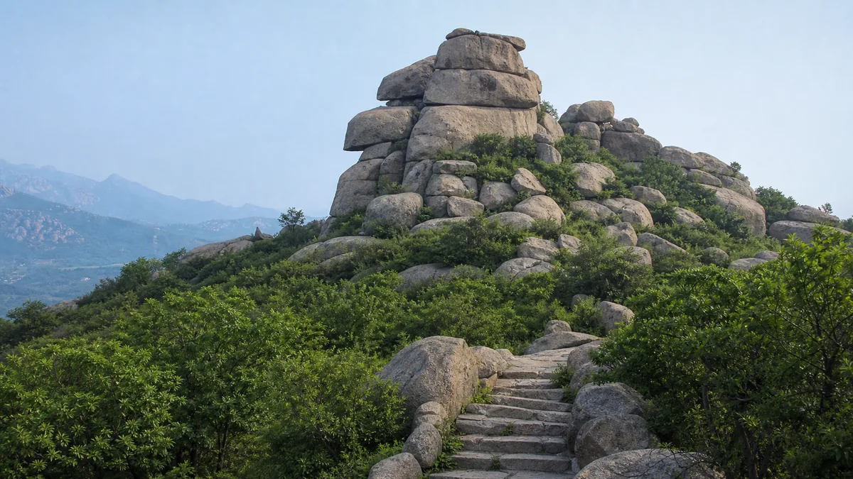
5A View location, maps and nearby scenic areasStop beneath one of Mount Chaya’s rounded granite blocks and move three or four paces sideways. A stone that first looked like a crouching animal may become a profile, then lose the resemblance entirely. Above it, another boulder seems to rest on too little support. The rock has not moved; your viewpoint has.
That small experiment is the best introduction to Cháyá Shān—roughly pronounced “cha-ya shan”—in Suiping County, under Zhumadian, southern Henan. The mountain is known for compact granite peaks, stacked blocks, crevices and weather-rounded forms. It is also marketed through legends and modern Journey to the West television associations. Those are layers of human imagination placed on a real landform, not substitutes for its geology or for the novel’s history.
Plan by effort, not by the number of named rocks. A short visit should concentrate on a lower-to-middle circuit and several changing viewpoints. A long visit can add upper stairs, tighter passages and a ridge connection. Ask at the entrance which direction, transfers and exits are operating that day; wet weather, maintenance and crowd control can alter the map.
The mountain is a cluster, not one pointed summit
From a distance, Mount Chaya does not present one clean cone. It appears as a compact group of domes, blunt ridges and detached-looking blocks, with vegetation filling the joints. Close up, the gaps become corridors, steps and windows. This change of scale explains why a modest-looking hill can require more effort than its skyline suggests.
The highest elevations in the scenic area are commonly reported at about 786 metres above sea level. Published figures can vary because “Mount Chaya” may refer to a principal summit, a wider hill group or the managed tourism area. Elevation is also not the same as the vertical climb from the gate. For a visitor, cumulative stairs, repeated descents and climbs, heat and the distance to an exit matter more than summit altitude alone.
Chaya lies on the eastern side of the broader Funiu mountain system, where the high ranges grade toward the plains of southern Henan. Its identity comes from exposed granite rather than from alpine height. The scenic-area classification and national 5A rating describe visitor management and tourism status; they do not date the rocks or certify every promotional superlative.
Use people, railings and pines for scale. A block that looks hand-sized in a wide photograph may be several metres across. Conversely, two “peaks” in a compressed telephoto image may be separated by a deep notch and a long staircase. The mountain repeatedly corrects what a flat image makes simple.
Granite becomes dramatic by breaking slowly
Granite forms when molten rock cools below the surface. Later uplift and erosion remove overlying material and expose it. As pressure is released, fractures develop roughly parallel to the surface; other joints cut across them. Water enters these weaknesses, temperature changes work on the edges, roots exploit cracks and loosened grains are carried away.
Over long periods, corners and edges weather faster than protected cores. Angular masses become rounded blocks. Closely spaced joints divide rock into smaller units; wider spacing leaves larger domes and walls. When softer or more fractured material disappears around a resistant block, the survivor can look balanced, suspended or deliberately placed.
Visitors sometimes encounter exact ages for every boulder or a single explanation for every cavity. Treat such precision cautiously unless a geological panel identifies what was measured. The granite body, its exposure, the opening of joints and the rounding visible today belong to different stages. A rock can be ancient while its present outline is a much younger product of continuing weathering.
Look for three clues rather than memorising technical terms. First, trace straight fractures through an otherwise rounded surface. Second, notice orange, grey or dark weathering skins where water has acted differently. Third, inspect the narrow contact beneath a “balanced” block from a safe path. It usually reveals a remaining rock support, not a stone frozen in mid-air.
A named stone is a viewing instruction
Maps and guides attach characters, animals and objects to Mount Chaya’s rocks. The names vary across route maps and storytelling traditions, and some labels are more recent than visitors assume. A resemblance is not a hidden fossil or a sculpture left by an unknown civilisation. It is a collaboration among erosion, angle, light and the human tendency to find a face in irregular forms.
That does not make the names meaningless. A good rock name functions like an instruction: stand here, look between these branches, turn the outline against the sky. Walk beyond the prescribed point and watch the image dissolve. Children often understand this immediately; adults sometimes remain trapped by the signboard, trying to force every angle into the advertised shape.
The Song poet Su Shi, writing about another mountain, famously observed that a ridge becomes a peak when seen from a different side. His line is not evidence about Chaya, but it offers a useful Chinese viewing method: no single perspective exhausts a mountain. At Chaya, the modern echo is the phone screen. Take the labelled photograph if you want it, then lower the camera and change position until the stone becomes geological again.
Local stories may explain a gap as a giant’s blow or a rock as a transformed being. Hear them as cultural memory and performance, not as rival geology. The mountain is richer when visitors can hold both categories without making either pretend to be the other.
What Journey to the West did—and did not—bring here
Mount Chaya’s strange silhouettes make an intuitive stage for Sun Wukong, demons, caves and magical transformations. Tourism displays and local accounts connect the mountain with location work for modern television versions of Journey to the West, especially the cultural afterlife of the influential CCTV series commonly called the 1986 adaptation. Exact scenes, filming units and later reshoots are sometimes described differently, so dated production evidence is more reliable than a souvenir caption.
The safe historical distinction is clear. Filming association is not literary origin. The novel Journey to the West took shape in the sixteenth century from earlier stories, religious traditions, theatre and the historical memory of the Tang monk Xuanzang. Its authorship is conventionally associated with Wu Cheng’en, although scholarship discusses the publication and attribution history. Neither the novel’s creation nor Wu Cheng’en’s life can be relocated to Mount Chaya because a twentieth-century production used or evoked its scenery.
The television connection still matters. It taught generations of viewers how a supernatural mountain might look: deep cracks become demon caves, stacked blocks become thresholds and a backlit ridge becomes another realm. Guides, signs and visitors then carry those camera memories back to the real landscape. This is a genuine modern cultural loop—geology inspires screen scenery, and screen scenery teaches people how to see geology.
Ask two questions at a themed viewpoint. What rock and vegetation are physically present? What framing, character or episode does the display invite you to remember? Keeping the answers separate prevents debunking from becoming joyless and nostalgia from becoming false history.
The landscape includes work, water and ordinary lives
It is easy to describe Mount Chaya as though weathering alone produced the visitor experience. In practice, paths, stone steps, drainage, railings, viewing decks, reservoirs or lakeside edges and transport links turn a rock cluster into a managed day out. Trail crews and local staff continually remove hazards, direct crowds and close sections when a route no longer offers a safe passage.
The mountain also sits within Suiping’s lived landscape rather than outside human geography. Villages, farming, water management, road access and tourism employment surround it. Granite slopes shed water quickly in storms but can hold moisture in shaded joints; lower water bodies and green edges soften the visual transition to the plain. Their appearance and level are seasonal and managed, not timeless ornaments guaranteed to match publicity photographs.
Tourism brings income and a larger audience for the landscape, but also pressure: paved surfaces, queues, litter, noise and repeated off-trail shortcuts can damage thin soils and vegetation growing in cracks. Do not climb an unprotected named boulder for a more dramatic pose. A lichen-darkened surface is habitat and geological evidence, not a studio prop.
This human layer is worth noticing from a rest point. Count the drainage channels and repaired steps, listen for work vehicles and compare the spontaneous curve of a joint with the cut edge of a constructed stair. Conservation here is not the absence of people; it is the daily negotiation required to let many people enter a fragile, uneven landform.
Choose a short circuit or commit to the long mountain
A short route suits first-time visitors with limited time, families managing energy and anyone unsure about repeated stairs. Ask staff for the current circuit that reaches several core granite formations and a lake or lower panorama before returning to an operating exit. The aim is not to collect every label. Three formations seen from multiple angles explain Chaya better than ten signs passed at speed.
A long route adds upper slopes, more sustained stairways, narrow rock corridors and potentially a connection between sectors of the mountain. It offers broader views and the pleasure of seeing the granite mass change from enclosed passages to open ridges. The cost is cumulative effort: a descent may lead to another climb, and the nearest exit may not be where you began.
Before committing, photograph the current map and mark the last sensible turn-back point. Confirm whether scenic transport, one-way trail management or a transfer between gates is operating. A lift, shuttle or water crossing shown in an old itinerary may be suspended, separately ticketed or irrelevant to today’s route. Do not build a tight onward train or flight connection around an estimated hiking time.
For mixed-ability groups, agree on a reunion point in a lower area rather than pushing everyone through a narrow upper section. Mobile reception can weaken between rocks. Keep the Chinese name 嵖岈山 and the entrance name saved on the phone so that staff and drivers can identify the correct pickup point.
Heat, wet stone and stairs decide the day
The mountain’s main risks are ordinary enough to be underestimated. In hot, humid weather, exposed granite reflects heat while wooded notches restrict air movement. Repeated steps raise exertion quickly. Start earlier when current opening arrangements allow, carry permitted water, eat before fatigue becomes nausea and choose the short route if the group is slowing at the first major climb.
Rain changes the problem. Smooth granite, worn stair edges, algae near water and leaf-covered joints can become slick. Handrails help but may be wet, hot or crowded. Shorten your stride, keep both hands available and wait for people descending a narrow passage instead of squeezing past. Shoes with tread matter more than fashionable waterproofing.
Thunderstorms and heavy rain can bring runoff, falling branches, loose material and temporary closures. Staff may close a route even when the entrance area looks calm, because conditions higher or farther inside differ. Treat barriers as live safety decisions. Never step around one because a social-media post shows the path open on another date.
In cold conditions, shaded moisture can remain after sunny rock has dried. In every season, check dated notices for trail direction, maintenance, fire controls and transport. “The mountain is open” does not necessarily mean every staircase, bridge or upper viewpoint is available.
Photograph the relationship, not just the silhouette
The standard photograph isolates a named stone against blank sky. Make a second frame that explains how it stands: include the supporting rock, a joint line, vegetation or a person on the official path. A wide lens works inside narrow passages, but keep faces away from the stretched edge. A moderate telephoto lens can layer domes from a viewpoint, though it will compress real distance.
Side light reveals grain, cracks and rounded corners. After rain, colour deepens but footing worsens; make the safe photograph from a stable platform rather than chasing a reflection on polished stone. Midday light can be harsh, yet it may clarify the small contact beneath a balanced block. Weather decides which visual story is available.
Do not stop in a narrow stair flight for a long portrait session, fly a drone without current permission or cross a rail to remove other visitors from the composition. If a viewpoint is busy, take one record image and wait at a wider rest area. The mountain’s changing profiles reward movement more than possession of one empty frame.
Accessibility is uneven. Lower paved or lakeside areas and transport-assisted stops may offer a meaningful introduction, while signature rock corridors usually include steps, irregular surfaces, gradients and tight turns. Wheelchair users and visitors with limited stamina should ask specifically about step-free distance, vehicle boarding, accessible toilets and whether an advertised viewpoint can be reached without stairs. “Easy route” can still mean a mountain route.
Leave after the rock loses its borrowed face
Before exiting, return to one formation you recognised instantly on arrival. Do not stand on the marked photo spot. Move until the monkey, tortoise, face or tower disappears, and the named stone becomes a rounded granite mass crossed by joints.
That loss is not a disappointment. It gathers the mountain’s two histories into one view. Geological time made a block durable enough to remain while its surroundings weathered. Human time gave it a name, a legend, a television memory and a place on a route map. Neither story needs to erase the other.
For another Henan mountain where dramatic terrain meets a large living Buddhist complex, continue to Mount Yao and the Central Plains Buddha. Mount Song offers a different relationship among geology, sacred history and strenuous ridge walking, while the Funiu Mountains guide separates mountain ecology from a geographically distinct dinosaur-egg fossil site.
Leave enough energy for that final sideways step—and enough space on the path for someone else to make it. The most faithful photograph of Chaya may be a pair of frames taken seconds apart: one shows the story you recognised, the other shows how quickly the mountain became itself again.
Location profile
Where it is

Frequently asked questions
How difficult is Mount Chaya, and is there an easy route?
There is normally a shorter circuit concentrating on lower viewpoints and the central granite formations, while longer routes add sustained stairs, ridge sections and more transport coordination. Trail direction and access can change, so show staff your available time and mobility needs before entering rather than relying on an old online map.
Was Mount Chaya the birthplace or original setting of Journey to the West?
No verified literary history supports that claim. Mount Chaya is associated with location work and tourism imagery linked to modern television adaptations of Journey to the West. The sixteenth-century novel emerged from a much broader tradition and cannot be assigned to this mountain simply because its rocks resemble scenes or characters.
When is Mount Chaya most slippery or uncomfortable?
Rain and lingering moisture make polished granite, steps and narrow passages slippery; midsummer heat and humidity can make exposed climbs exhausting. Start conservatively, wear shoes with reliable grip, carry permitted water and follow closures after storms. Weather, water features and trail openings should be checked in current scenic-area notices.
Can visitors with limited mobility see Mount Chaya's rock scenery?
Some lower areas, lakeside paths and transport-assisted viewpoints may be more manageable, but the mountain's signature passages often involve uneven stone, repeated steps, slopes and tight spaces. Accessible vehicles and open routes vary, so confirm step-free access, toilets, transfer points and companion arrangements directly with the visitor centre.