Henan · Luoyang
Longtan Grand Canyon: Read Water in Red Sandstone
Walk between red quartz-sandstone walls, ripple-marked beds and plunge pools while learning how joints, floods and rockfall—not one simple act of erosion—opened Longtan Grand Canyon.
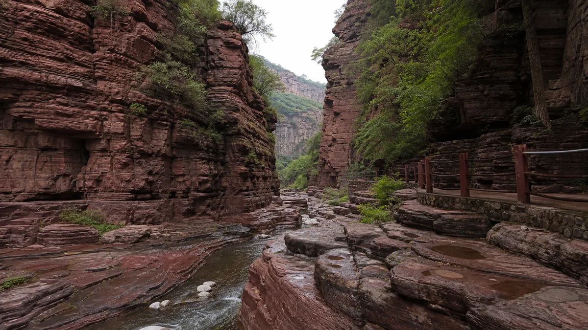
5A View location, maps and nearby scenic areasPlace your palm near—but not on—the red wall where the path narrows. Quartz grains make the surface feel visually granular, thin beds run across it like pages, and dark damp streaks descend toward the stream. The canyon’s drama is not just the height of the walls. It is the short distance between rock, water and visitor.
Longtan, pronounced roughly long-tahn, means “dragon pool.” Names and promotional photographs pull attention toward pools and waterfalls, but begin with the wall. Bedding records sediment laid down long before a gorge existed; joints gave later water lines of weakness; blocks detached under gravity; floods moved broken material downstream. No single process carved every recess.
Use three checks before committing: read the day’s entrance-to-exit direction; ask whether scenic transport and all walkways are operating; check rain and closure notices for the canyon itself. A one-way plan, waterfall volume or open narrow section should never be assumed from an undated post.
Red beds came before the canyon
The dominant rock is commonly described as red quartz sandstone. Sand-sized grains rich in durable quartz accumulated in an ancient sedimentary basin, were buried and cemented into rock, and later became part of an uplifted landscape. Iron-bearing minerals and coatings contribute much of the red, brown and purple colour. “Red rock” therefore describes composition and weathering colour, not lava and not a recent stain from the stream.
Tourism material often gives a single spectacular age for the sandstone or a precise duration for canyon cutting. Those figures may combine the estimated age of a rock unit with a much later phase of incision, and they can change as geological interpretation improves. On site, keep the sequence clear without false precision: sediment accumulated; rock formed; the region fractured and rose; drainage cut downward; weathering and collapse widened selected spaces.
Look across the canyon rather than only up. Repeated horizontal beds show changing pulses of deposition. Some layers resist wear and project as ledges; weaker beds retreat and form grooves. The result is a stepped wall built by differences within the sandstone, then sharpened by frost, roots, rain and gravity. The rock is ancient; the visible cliff is a continuing landform.
Water follows cracks before it makes curves
The Chinese saying 滴水穿石 is usually translated as “dripping water wears through stone,” a lesson about persistence. Longtan makes the image memorable but also corrects it. Flowing water works most efficiently where tectonic joints, bedding planes and existing fractures already weaken the rock. Sand and pebbles carried by floods abrade the bed; swirling flow can enlarge hollows; chemical weathering loosens cement; gravity removes unsupported blocks.
That chain produces a zhanggu, or narrow steep-walled barrier gorge, in sections where the stream cuts between near-vertical rock faces. Smooth pothole-like basins do not prove that one pebble spun in one place for millions of years. Several floods, changing sediment loads and later weathering can reshape them. Likewise, an alcove may owe as much to a collapsed slab as to direct scouring.
Trace a joint upward with your eyes. Where vertical fractures intersect horizontal bedding, rectangular blocks are outlined. Water enters, temperature changes expand and contract the surface, roots exploit openings, and eventually gravity can win. The block at your feet and the void above it are two parts of the same event. This is why rockfall barriers and temporary inspections are not inconveniences unrelated to geology; they respond to the active processes visitors came to see.
Ripple marks are evidence, not a frozen sea
Some exposed bedding surfaces preserve ripple marks, cross-bedding, mud cracks or other sedimentary structures. Ripples form when moving water or waves rearrange loose grains; cross-beds record migrating ripples or dunes; desiccation cracks form when wet, fine sediment dries and shrinks. Once buried and cemented, those temporary surfaces can survive inside rock.
Tourism descriptions sometimes call Longtan a “natural museum of an ancient ocean.” Treat that as an interpretive slogan rather than a complete environmental reconstruction. Different beds may record different shallow-water, shoreline, river or basin conditions, and a ripple shape alone does not identify one exact sea level or date. Read the geological panel beside the actual surface and distinguish a mapped formation from a poetic name.
Photography can help analysis. Take one image perpendicular to a ripple surface so the pattern is clear, then a wider image showing which bed it belongs to. Do not scratch a line, wet the rock for stronger colour or remove a flake. A loose-looking piece is still part of a protected geological site, and its position carries information that a souvenir cannot.
Collapse is part of the architecture
Narrow gorges are often narrated as if water patiently polished a finished corridor. Longtan is more episodic. Intense runoff can undercut a wall or clear debris; a freeze-thaw cycle can open joints; a slab may detach suddenly; the stream then reorganises around the new obstruction. Pools can form behind bedrock steps or fallen blocks and later fill with sediment or be scoured again.
This explains why a photograph from one season may show a clean cascade while another shows gravel, a shallow trickle or brown storm water. It also explains overhangs and giant blocks that appear too angular to have been “carved” into place. Water incision, physical weathering, mass movement and sediment transport act together at different speeds.
Do not test an overhang, stack stones in the channel or enter a roped-off recess. Small falling fragments can precede larger instability, especially after rain or alternating thaw and freeze. If staff stop movement for an inspection, the correct response is distance, not a quick dash beneath the wall. A canyon is not a static set built for uninterrupted access.
One gorge belongs to a much larger geopark story
Longtan Grand Canyon is associated with the Daimeishan sector of the Wangwushan–Daimeishan geological-park landscape. That wider frame matters. The geopark contains more than one gorge and more than red sandstone: it connects rock successions, uplifted mountain terrain, Yellow River landscapes, structural geology, ecosystems and communities across a broad part of western Henan.
A geological-park label does not mean every attraction is one continuous park that can be walked in a day. Nor does it make scenic-area marketing terms scientific rankings. Phrases translated as “China’s first gorge,” “the finest canyon” or “unique in the world” should be read as tourism language unless a claim identifies a measurable category and a responsible source. Longtan does not need a superlative to be significant; its close, readable combination of bedding, joints, red walls and active water is enough.
The designation also implies responsibility. Geological heritage loses value when visitors chip ripple marks, widen informal paths or leave rubbish that washes into pools. Conservation teams, guides, maintenance workers and nearby residents make a safe public route possible through terrain that would otherwise be difficult to enter. The modern walkway is not the geology, but it shapes how geology can be seen without destroying it.
Water is both the subject and the operating condition
Stream flow changes with rainfall, season, upstream catchment conditions and management. In a wet period, cascades may be louder and red walls darker, but paths are slicker and flash-flood risk rises. In a dry period, bedding and potholes can be easier to inspect while waterfalls shrink. Neither condition is a failed visit; each reveals a different part of the system.
Plants occupy ledges, joints and humid corners where soil and water collect. Moss colour can signal persistent spray, but a green surface is also slippery. Do not step off the path to reach a fern or pool. Food scraps alter animal behaviour, and detergent or “wishing” objects pollute confined water. Carry out what you bring in and use toilets and waste points before committing to the narrowest section.
The human history visible today is largely one of access. Villages and roads long predate mass tourism, while stairs, rails, bridges, shuttle links and emergency systems turned a difficult ravine into a managed attraction. Tourism can support local employment but also concentrates traffic, waste and water demand. Respect signed community space and avoid treating every working building outside the gate as part of a theme park.
Let the day’s direction decide the route
Published itineraries commonly describe a through-canyon or largely one-way walk, sometimes using a scenic vehicle to connect the entrance, upper end or exit. The exact direction, included transport, intermediate shortcuts and last departure are operational choices. Storm damage, construction and crowd control can reverse or shorten a route. Confirm the diagram at the ticket gate before boarding any vehicle, because discovering the day’s direction after a long ride can leave no practical way to retrieve luggage or meet a driver.
For a geology-first visit, move slowly through the narrow rock sections and allow faster groups to pass at wider bays. Choose two or three features—bedding, a joint-controlled corner, ripple marks, a collapse block—rather than stopping at every named formation. For a family or limited-stamina visit, ask whether a shorter out-and-back segment is currently authorised. Never assume you can turn around against one-way crowd flow.
The canyon is outside central Luoyang and road journeys can be affected by traffic and mountain conditions. Treat advertised transfer times as estimates. Reserve margin before the last shuttle, bus or pre-arranged pickup, keep the accommodation or driver’s Chinese contact details offline, and confirm whether a ticket includes every internal vehicle. If an upper gate closes, staff instructions outrank your saved map.
Rain changes the safety calculation quickly
The safest question is not “Will it rain?” but “What happens here if rain falls upstream?” A narrow catchment can concentrate runoff rapidly even when the path itself began dry. Thunder, rising or muddy water, debris noise and staff whistles are reasons to move to directed higher ground and follow evacuation instructions. Never cross a barrier to see a flood pulse.
Wear shoes with wet-rock grip and keep both hands available on narrow steps. Polished stone, algae, spray and fallen leaves reduce friction. A light rain layer is more useful than an umbrella where the path is tight. In cold weather, shaded ice may persist after sunny areas thaw. Heat also matters: humid walls reduce airflow, and a through-route can offer fewer easy exits than its map suggests.
Rockfall risk increases after heavy rain, freeze-thaw conditions and wall disturbance. Do not linger under fresh debris, climb onto detached blocks or rest against a cliff where warning signs prohibit stopping. Full or partial closure can result from storm forecasts, inspections, damaged rails, ice or maintenance. A closure is a safety decision, not a challenge to find an unofficial entry.
Accessibility is shaped by the narrowest section
Approach plazas and some transport may be step-free, but that does not make the entire canyon accessible. The through-route typically involves sustained walking, stone stairs, narrow bridges, wet surfaces and limited places to reverse. Wheelchair users and visitors with significant balance or knee limitations should ask the operator for the exact currently accessible segment, vehicle boarding arrangement and toilet locations before buying a full-route ticket.
Children need close supervision beside water and in crowded constrictions. A carrier can be awkward on low or narrow passages, while a stroller may be unusable beyond paved areas. Older visitors should plan rest before fatigue affects foot placement. Mobile signal can be intermittent; save emergency and meeting information offline and keep companions together.
For photographs, a person placed well away from the camera can communicate wall scale without blocking the path. Overcast light controls contrast between bright sky and dark canyon, while side light reveals bedding. Protect equipment from spray, but never occupy a bridge or narrow stair for a tripod shot. Water levels, shafts of light and empty viewpoints are conditional—not scenes the ticket promises.
Return to the wall, not the slogan
Near the exit, find another red face and compare it with the opening wall. You can now separate bedding from joints, erosion from collapse, and an ancient sedimentary surface from the modern stream. The canyon is less a single sculpture than a sequence of inherited weaknesses repeatedly edited by water and gravity.
That reading also changes the famous saying. Persistent water matters, but it works through structure, storms, sediment and sudden failure. Longtan’s modern echo is practical: patient observation should make a visitor more willing to obey a closure, not more determined to defeat it.
Take the final photograph wide enough to include a rail or path; the small human line explains both scale and the work required for access. Then put the camera away before the last wet steps. Continue through western Henan at Baiyun Mountain for forest and changing ridge weather, Mount Laojun and Jiguan Cave for a mountain-and-cave contrast, or the three-part Yuntai Mountain scenic designation for another lesson in conditional water and separated landscapes.
Location profile
Where it is

Frequently asked questions
Is Longtan Grand Canyon a one-way walk?
It is commonly operated as a through-canyon route supported by scenic transport, but the starting end, walking direction, open sections and return arrangement can change with maintenance, weather and crowd control. Confirm the day's route map and last vehicle before boarding; do not rely on an older blog's direction.
How difficult is the Longtan Grand Canyon trail?
The main challenge is sustained walking on stone steps and narrow, sometimes wet surfaces rather than high altitude. Distances feel longer when the gorge is crowded or slick, and some bypasses may close. Visitors with limited balance, knee problems or young children should ask which shortened route is currently possible before entering.
Are the waterfalls and pools full all year?
No fixed water level is guaranteed. Rainfall, season, upstream conditions and scenic-area management all affect stream flow, pool appearance and waterfall volume. Heavy rain can make the canyon dangerous and trigger closure, while dry periods can reduce cascades; check current notices instead of planning around promotional photographs.
When can Longtan Grand Canyon close at short notice?
Thunderstorms, intense rainfall, flash-flood risk, falling-rock inspections, ice, damaged walkways or other maintenance can close all or part of the route. Weather at the canyon may differ from Luoyang city. Check official notices on the day, obey barriers and evacuation instructions, and keep enough schedule flexibility to turn back or skip the gorge.