Henan · Luoyang · Song County
Baiyun Mountain, Henan: Forest, Falls and Summit Routes
Choose among Funiu forest, ridge, waterfall and Yuhuangding summit zones, with realistic advice on shuttles, cableways, changing weather and protected mountain ecology.
5A View location, maps and nearby scenic areasStep off the scenic shuttle and wait before choosing the first stairway. One sign may point uphill toward Yuhuangding, another toward a waterfall valley, while a wooded path disappears beside the road. The air can be cool and damp even when the lowlands around Luoyang are hot. This is the practical truth of Baiyun Mountain: the “attraction” behaves like a mountain district, not a single lookout.
Its name, Baiyunshan (roughly “bye-yoon-shahn”), means “White Cloud Mountain.” Cloud may stream across the ridge—or the sky may be completely clear. Either way, the forest, water and rock remain. A good visit is designed around a landscape zone, not around a promised photograph.
Build the day from one major choice: forest and lake for gentler walking; the Jiulong waterfall zone for wet steps and valley depth; a ridge route for sustained hiking; or Yuhuangding for height. Shuttles and cableways connect parts of the system, but they do not turn all four into one effortless circuit.
Treat Baiyun Mountain as a small mountain district
Henan’s Baiyun Mountain lies in Song County, south of Luoyang, within the eastern Funiu Mountains. The Funiu range is an extension of the Qinling mountain system and forms a broad transition between warm-temperate northern landscapes and the northern subtropics. That position helps explain why altitude, slope direction and moisture produce visibly different woodland conditions within a relatively compact area.
Visitor literature has divided the park into named zones such as Yuhuangding, Baiyun Peak, Jijiaoman ridge, the Jiulong waterfalls, forest walks and lakes. Names and operational groupings can change, and a scenic ticket does not mean every trail begins at the same gate. Think of it like choosing among trailheads in a national park rather than walking through one urban garden.
Road distance is also deceptive. A point that looks close on a schematic map may require a shuttle transfer, a cableway queue and a final staircase. Conversely, a quiet woodland circuit near a visitor hub can deliver a satisfying half day without reaching a famous peak. Photograph the current map, identify the last practical return connection, and ask which trail sections are one-way before setting out.
The Baiyun Mountain 5A profile supplies the location anchor. On the mountain, dated operating notices are more useful than an old online itinerary with exact minutes.
Read the forest vertically, not as one green blanket
Walk slowly from a sheltered valley toward an exposed slope. Broad leaves, conifers, shrubs, moss and ground plants do not form a uniform “primeval forest”; they respond to elevation, sunlight, soil and human use. Cooler upper areas leaf out later in spring and can enter autumn colour earlier than the lower approach.
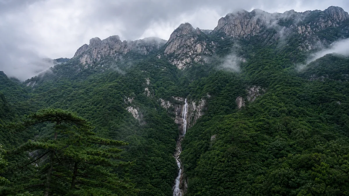
This vertical change is one of Baiyun Mountain’s strongest sights. Forest blocks long views, then a gap suddenly reveals folds of the Funiu range. On damp days, trunks and needles catch cloud droplets. On dry days, resin, leaf litter and sun-warmed rock replace the expected mist. Neither condition is less authentic.
The wider Funiu landscape supports high biodiversity and important headwater forests. Baiyun Mountain has long been promoted as a national forest park and nationally protected nature-reserve landscape. Those labels are not permission to treat every organism as a display. Wildlife usually avoids busy paths; a rare-animal list is not a sighting guarantee. Keep distance from any animal, never feed it and do not play calls to draw birds closer.
Protection boundaries and visitor zones are not identical. Some areas are built for concentrated access while more sensitive forest is restricted. Stay on marked paths, carry out litter and avoid picking flowers, fungi or “souvenir” stones. The least dramatic choice—keeping boots off a soft forest floor—protects roots and small plants that make the mountain feel intact.
Yuhuangding gives height, not a guaranteed panorama
Published scenic sources commonly give Yuhuangding an elevation of about 2,216 metres. It is often marketed as the “highest peak of the Central Plains,” but that title depends on how “Central Plains,” mountain boundaries and surveyed summits are defined. The useful onsite fact is simpler: the summit stands high enough above the main visitor zones for weather and effort to change materially.
“Yuhuangding” means Jade Emperor Summit, a name drawn from the supreme deity of popular Daoist cosmology. A summit structure and the name add a cultural layer, but the climb should not be reduced to a claim of ancient continuity for every visible building. Mountain shrines and visitor facilities can be rebuilt, repaired or recently installed; age should be established feature by feature.
When a cableway is operating, it can remove a long part of the ascent. It normally does not place you at the final high point without further steps. Queues, wind holds, maintenance and ticket combinations change. Visitors walking the full climb face repeated stone stairs and thinner, cooler air; those riding still need footwear and enough stamina for the upper approach.
At the top, haze or cloud may erase the horizon. Instead of declaring the climb wasted, look close: wind-shaped vegetation, wet stone, railings vanishing into mist and sudden openings explain elevation as clearly as a distant panorama. In exposed weather, leave before cold hands and poor visibility make descent harder.
A ridge route is about movement across terrain
Ridge and Baiyun Peak routes trade the single summit target for changing rock forms and repeated views. Older scenic maps often name Jijiaoman, sometimes promoted as “Little Huangshan,” alongside Baiyun Peak and nearby crags. The comparison is tourism shorthand, not a geological identity with Huangshan in Anhui.
On a ridge, the work comes in waves. A viewpoint is followed by a descent, then another rise; “mostly downhill” may still contain hundreds of steps. Forested saddles can be calm while exposed ribs receive strong crosswinds. Fog makes junctions harder to read, and wet rock can be slick even after rain has stopped.
Choose this route if the act of hiking matters more than collecting one summit sign. Start with the current trail diagram rather than assuming every historic place-name remains open or uses the same English transliteration. Ask staff whether a route returns to its starting point, finishes at another shuttle stop, or has a one-way control.
Ridge travel also reveals scale. Put a person or a known railing in a photograph, and the folds of the mountain become legible. Without that reference, telephoto compression can make separate slopes look like one wall. Do not step beyond a barrier for “clean” foreground; the barrier is often marking unstable or ecologically sensitive ground.
The waterfall records recent weather, not a fixed output
The Jiulong waterfall area draws visitors down into a steeper water-shaped landscape. Paths can include long flights of steps, damp platforms, narrow sections and cableway or shuttle connections. The route’s physical direction matters: descending first may leave the hardest climb for the return unless transport is operating as expected.
Promotional descriptions assign impressive heights and dragon imagery to individual falls. Measurements can vary depending on whether one vertical drop, a stepped cascade or the whole watercourse is counted. More important on site is the relationship between bedrock, channel and recent rainfall. Water follows cracks and ledges, accelerates at constrictions and spreads where the rock face changes angle.
Flow is seasonal and event-driven. After rain it can be powerful and spray can soak steps; in a dry period the same cliff may show delicate threads. Storms can also trigger closures because rockfall, runoff and slippery surfaces matter more than spectacle. Never cross a barrier to reach a “better” pool view, and do not enter water where signs prohibit it.
For photographs, use a stable designated platform and protect electronics from spray. A fast shutter freezes texture; a slower exposure suggests movement but requires a secure support and must not block the path. Including people at a safe distance gives scale without pretending that one water level is permanent.
Protection changed how people use the mountain
Baiyun Mountain was designated a national forest park in 1992 and later received national-level nature-reserve and 5A tourism recognition. These designations mark a modern history in which a working mountain landscape became increasingly managed for conservation, research and visitors. They do not mean human presence suddenly began in the 1990s.
Local communities knew paths, water and seasonal conditions long before scenic maps divided them into zones. Today residents and workers support accommodation, food, road maintenance, shuttles, rescue, forestry and conservation. Tourism brings livelihoods and access infrastructure, but also traffic, waste, noise and pressure to extend facilities. “Protected” is a continuing negotiation, not a fence that solves every problem.
The sixth-century poet and recluse Tao Hongjing once answered a court question with lines often translated, “What is there in the mountains? Above the ridge are many white clouds.” He wrote about another mountain, not this one, so the verse is analogy rather than local evidence. Its story still clarifies Baiyun’s appeal: court asked what remote mountains could offer, and the answer named something beautiful that could be seen but not sent as a possession.
That idea has a modern ecological echo. Clouds, flowers and wild creatures make poor trophies. Photograph them, leave them in place and let the mountain retain what drew you there.
Let one question choose your route
For a gentler forest day, combine a woodland path, lake area and short viewpoints using current shuttle stops. This offers shade and ecological detail, though “gentle” still means gradients, paved distance and occasional steps. It is the best fallback when high routes are obscured or closed.
For a waterfall day, give the Jiulong zone enough time to negotiate wet stairs without rushing. Confirm whether the day’s recommended sequence descends, ascends or uses a cableway, and where the return shuttle boards. Do not attach a summit simply because both appear on the same ticket.
For a summit day, make Yuhuangding the primary goal. A cableway can conserve energy, but retain time and clothing for the upper steps and uncertain visibility. Sunrise plans normally require an overnight stay and specific early access; verify accommodation, transport and gates rather than assuming the summit is freely accessible before dawn.
For a strong hiking day, choose a ridge or Baiyun Peak route and carry a paper or saved map. Link only those zones that staff confirm are connected. Trying to complete summit, ridge, waterfalls and forest in one rigid day turns the visit into a race between vehicles. If Funiu ecology is your main interest, later compare this landscape with the distinct Old Boundary Ridge component in the Funiu Mountains guide.
Clouds, flowers and weather keep their own calendar
A sea of cloud needs moisture, temperature structure and suitable wind. Sunrise needs a clear eastern horizon at the right moment. Neither is included in admission. Build a second visual goal—forest texture, moving fog or close rock detail—so the mountain remains rewarding when the postcard does not appear.
Rhododendron and other flowering periods shift with altitude and annual warmth. A social post dated only “spring” is not a reliable bloom report. Autumn colour also moves downslope over time rather than switching on everywhere at once. Check recent, dated local observations and never leave the path to enter a flowering slope.
Mountain weather can change between shuttle stops. Carry a light waterproof layer and an insulating layer even when the valley forecast looks mild. Thunder, strong wind, ice or intense rain can suspend cableways and close trails. Follow staff instructions early; waiting for a storm to become visually dramatic is not worth losing a safe return.
Save the destination name and accommodation address in Chinese if staying overnight. Mobile signal and batteries can weaken in cold or enclosed valleys. Keep water, essential medication and enough daylight margin for a transport change.
Photograph patiently and define accessibility honestly
In forest, expose for the brightest patch of sky so leaves keep detail, then use trunks or a path curve to lead the eye. At a ridge, wait for a cloud opening rather than walking into an unsafe position. At waterfalls, wipe the lens often and keep bags away from drainage edges. A subdued image of mist between trees may describe “White Cloud Mountain” better than an oversaturated panorama.
The scenic road and shuttles make a high landscape more reachable, but they do not make it fully barrier-free. Vehicle steps, queues, platform gaps and transfers can be difficult. Historic or mountain paths have stairs, uneven paving and steep gradients; upper ridges and waterfall descents are unsuitable for wheelchairs.
Visitors with limited mobility should ask which lake, forest or viewpoint stops currently have step-free boarding, short paved access and accessible toilets. Cableway staff should confirm wheelchair dimensions, transfer requirements and companion rules. Do not infer accessibility from the mere presence of a cable car.
Everyone should budget knees as carefully as time. Trekking poles may help where permitted, but keep their tips away from fragile paving and other visitors. On crowded stairs, pause only at widened areas. Turning back because weather, transport or fatigue changed is sound mountain judgement.
Leave the mountain without demanding white cloud
Return to the place where the signs separated summit, water and forest. The mountain may now look different: a ridge hidden, a wet road drying, the canopy brightening after fog. You did not fail if sunrise stayed behind cloud, rhododendrons had not opened or the waterfall ran quietly.
Baiyun Mountain is valuable because no single condition defines it. Protected Funiu forest holds water and habitat; ridges expose weather; cascades register recent rain; summit steps reveal the cost of height. Roads, shuttles and cableways make selected pieces visitable while also reminding us that access has an ecological footprint.
For the final photograph, include the decision point itself—a trail sign, a strip of road and forest rising beyond. Then put the camera away before the last shuttle. The best pace here leaves enough time to notice the mountain changing, and enough margin to leave it safely.
Continue to Laojun Mountain for a contrasting summit shaped by Daoist association and modern architecture, or to Longtan Grand Canyon to read water in a more tightly confined red-rock landscape.
Location profile
Where it is

Frequently asked questions
Is this Baiyun Mountain the one in Guangzhou?
No. This guide covers Baiyun Mountain in Song County, within Luoyang Municipality in Henan's Funiu Mountains. Guangzhou also has a famous Baiyun Mountain, much closer to a major city and with a different landscape and transport system. Use 'Luoyang Baiyun Mountain' or the Chinese name 洛阳白云山 when booking.
Do I need a cableway to visit Baiyun Mountain?
Not for every route. Forest, lake or shorter valley walks may be combined with scenic shuttles, while cableways can reduce climbing on some summit or waterfall itineraries. They do not remove all stairs or guarantee access to every zone. Operations, boarding rules and package tickets change, so check the current map before paying.
Can I count on sunrise, a sea of clouds, rhododendrons or a full waterfall?
No. Sunrise and cloud layers depend on visibility, wind and overnight weather; blossoms shift with elevation and spring temperatures; waterfall volume responds to recent rain and water conditions. Treat each as a possibility. Check dated notices and forecasts, and choose a route that remains worthwhile without the headline scene.
How much of Baiyun Mountain should I plan for one day?
Most visitors should choose one major objective—Yuhuangding, the waterfall zone or a longer ridge—and pair it with one gentler forest or lake walk. Trying to collect every zone makes the day dependent on shuttles and queues. An overnight stay can create more flexibility, but accommodation, early transport and summit access should all be confirmed directly.