Shandong · Weihai
Liugong Island: A Naval Base, a Defeat and a Colonial Afterlife
Cross Weihai Bay to read a naval landscape shaped by the Beiyang Fleet, the 1894–95 war, ordinary lives under fire and the later British lease of Weihaiwei.
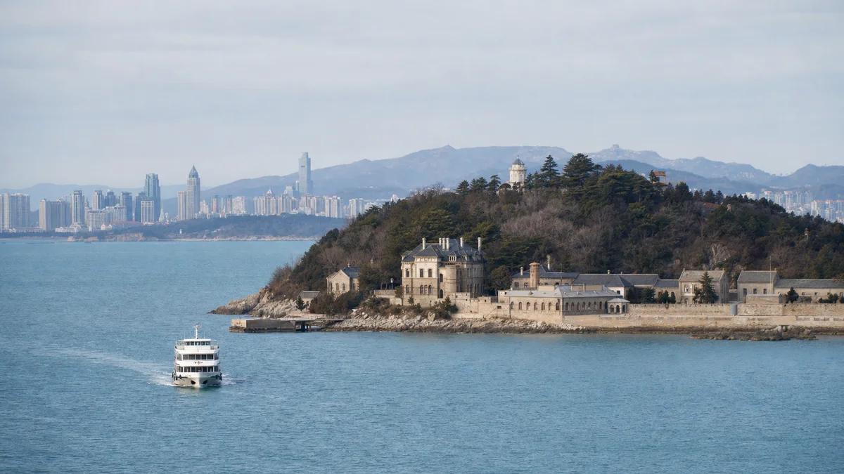
5A View location, maps and nearby scenic areasStand on the ferry’s open side as Weihai recedes. Ahead, Liugong Island first appears as a wooded ridge sheltering water, not as a battlefield. Then the harbour geometry begins to make sense: a fleet inside the bay, batteries watching approaches, workshops and command buildings near the shore. The island is not merely where history is displayed. Its position was part of the historical argument.
On the return crossing, the same short stretch of sea will look less neutral. It carried warships, wounded sailors, orders, supplies and, later, a colonial administration. Begin by reading the water before entering the museum.
Orient yourself in three layers: the landing-area cluster introduces the Beiyang Fleet and the 1894–95 war; former administrative and British-period buildings show how the island’s use changed; higher batteries and viewpoints reveal the bay as a defensive space. The island is compact, but these layers are not one flat indoor visit.
Read the island from the water first
Liugong Island lies across the mouth of Weihai Bay, close enough to the city for a short crossing yet far enough to control a sheltered anchorage. Its land area is only about 3.2 square kilometres, but its value came from position rather than size. Hills offered observation and gun sites; calmer inner water offered a place to concentrate ships.
As the ferry approaches, look back towards the modern Weihai waterfront and then along the island’s shore. This reverse view is useful. A battery was never an isolated cannon, and a naval headquarters was never only an ornate hall. Shore guns, signals, ships, docks, stores, repair capacity and information had to work as a system.
The surviving landscape does not reveal that system evenly. Trees, modern visitor facilities and later construction interrupt old sightlines. Use the shoreline and relief as the stable evidence; use models and maps inside the museums to test, not replace, what you saw outside.
How the Beiyang Fleet made Weihaiwei a base
Late Qing officials responded to foreign invasion and maritime pressure by purchasing modern warships, building arsenals and training new forces. In 1888 the Beiyang Fleet was formally organised, and Weihaiwei became one of its principal northern bases. Liugong Island gained command, training, maintenance and defensive functions around the anchorage.
This was not simply an encounter between “modern Japan” and an entirely “backward China.” The fleet possessed powerful foreign-built armoured ships, technical officers and experienced sailors. Its weakness lay across a larger system: divided command, uneven training and logistics, ammunition and maintenance problems, and political decisions that no single ship could correct. Historians continue to debate the weight of each factor.
At the former naval administrative compound, often translated as the Naval Office or Admiral’s Office, notice how bureaucracy and combat occupied the same base. Dispatches, accounts, discipline and supply mattered beside guns. Restored rooms can help visitors imagine those functions, but furniture arrangements and figure scenes are interpretation rather than a frozen morning from the 1890s.
The 1894–95 war closed around the harbour
The conflict usually called the First Sino-Japanese War in English began in 1894 amid competing Qing and Japanese influence in Korea. It was fought in and around Korea, northeastern China and the Yellow Sea; Liugong Island became decisive only in its final phase.
After the September 1894 Battle of the Yellow Sea, the damaged Beiyang Fleet withdrew to its bases. In early 1895 Japanese forces attacked Weihaiwei from land, captured coastal positions and tightened control around the bay. Guns from shore and torpedo-boat attacks made the anchorage a trap. Ships that had been designed to defend the base could not by themselves recover the landward forts protecting it.
By February, vessels had been sunk, damaged or captured and resistance collapsed. The surrender at Weihaiwei effectively ended the Beiyang Fleet as a fighting force. The Treaty of Shimonoseki followed in April 1895, imposing a major indemnity and territorial concessions on Qing China and accelerating Japan’s emergence as an imperial power. A museum route can make these events seem inevitable; they were instead a sequence of choices, failures, assaults and human losses.
Ding Ruchang was not the only life at stake
Admiral Ding Ruchang has become the island’s best-known individual. A cavalry officer before his naval career, he commanded the Beiyang Fleet through the crisis. With relief unavailable and surrender approaching, Ding took his own life in February 1895. Later memorial narratives have alternately made him a loyal martyr, blamed him for defeat or used his death to represent a collapsing state.
Do not let one biography absorb everyone else. Sailors below deck faced shell fragments, fire, flooding and torpedo strikes. Engineers and medical workers tried to keep damaged ships functioning. Some officers also died by suicide; others negotiated surrender in the hope of ending further killing. Survival, capitulation and courage do not fit into a single heroic category.
Nor was this an empty military stage. Residents around Weihaiwei lost homes, labour, food supplies and security as armies moved through the area. Civilians were displaced, injured and killed, although command records preserve their names and numbers far less consistently than those of senior officers. The war also directly affected Koreans, whose country was a central object and theatre of the rivalry. Keep those absences in mind when an exhibition offers a neat row of portraits.
Ask what survived, what was restored and what explains
Liugong Island is most honest when read as three kinds of evidence. Surviving fabric may include foundations, masonry, earthworks, sections of former military and administrative buildings, and British-period structures. Even genuine fabric has usually been repaired after weather, war and repeated reuse.
Restored or reconstructed places rebuild missing roofs, rooms, gun positions or spatial relationships so visitors can follow the site. They can be historically informed without being untouched originals. The iron pier and former naval compounds, for example, have long maintenance and repair histories; their present appearance should not be assigned wholesale to one date.
Museum interpretation includes models, mannequins, multimedia, reproduced documents and explanatory sequences. These are contemporary arguments about the past. Ask labels whether an object was excavated here, preserved in place, transferred from elsewhere or reproduced. A gun overlooking the sea may be an original object, a later replacement or part of a restored emplacement—the setting alone cannot decide.
British-leased Weihaiwei added another layer of power
Three years after the war, Britain leased Weihaiwei from Qing China in 1898, part of the great-power competition that was dividing strategic ports into spheres of control. Liugong Island again served naval purposes, now within a British-administered leased territory. British-era residences, service buildings and altered landscapes belong to this chapter.
The lease did not turn the entire territory into a miniature British city, nor was colonial rule simply a picturesque interval between wars. Administration differed between the island, port and rural hinterland; local Chinese residents continued to farm, fish, trade and negotiate with an unequal foreign authority. Buildings associated with officers preserve more visible evidence than the labour that serviced them.
Most of Weihaiwei returned to Chinese administration in 1930, while Britain retained Liugong Island for naval use until 1940. That staggered ending is easy to miss. It explains why “British Weihaiwei” cannot be assigned one clean endpoint everywhere, and why the island contains traces later than the better-known 1898–1930 lease dates.
Choose a route that preserves the story
For a focused half day, begin with the waterfront orientation and the principal Sino-Japanese War exhibition, then examine the former naval administrative area and one nearby harbour structure before returning. This gives the clearest sequence: why the base was here, how it worked, and how it fell. Read the first museum slowly instead of collecting every attraction name.
For a fuller day, add a higher battery or lookout and a British-period cluster. Sightseeing vehicles can reduce distance, but stops, routes and frequency may change. A high position is worth the effort because it reconnects indoor maps with the actual bay. Leave enough time to walk part of the descent: changes in angle reveal what a gun could and could not see.
Families or visitors sensitive to graphic history can divide the group between dense exhibitions and outdoor observation. Check current museum openings before fixing the order. Do not place the most distant stop immediately before the last ferry; one delayed vehicle can turn careful history into a stressful exit.
Let the ferry, weather and mobility set the limits
The ferry is part of the site and also its main uncertainty. Wind, fog, swell, seasonal timetables, maintenance and crowd control can delay or suspend crossings. Confirm the current departure pier, reservation or identification requirements, first and last boats, and any same-day notices through the official attraction channel. Keep a time buffer if you have an onward train or flight.
Weather changes the island itself. Sea fog can erase the mainland and make the defensive geography hard to read; clear air can expose the whole bay. Summer sun reflects off water, while exposed viewpoints can be cold and windy outside summer. Carry water and a wind or rain layer, and treat a closed battery or altered sailing as a safety decision rather than a missing promise.
Limited-mobility visitors should ask about both ferry boarding and the island route. Tides can change ramp angles; historic thresholds, steep paths and battery steps cannot all be removed. Sightseeing transport may make the main cluster manageable, but “vehicle accessible” does not mean every exhibition room or viewpoint is step-free.
Photograph with context, and leave memorials quiet
The ferry approach is the best place for a wide photograph connecting ridge, shore and water. On land, use a doorway or old wall to frame the modern harbour; at a battery, include the field of view rather than photographing only the gun. Morning, haze and backlight vary, so look for layered silhouettes instead of expecting a clear blue horizon.
Observe posted restrictions on flash, tripods, drones and photography inside exhibitions. Do not sit on guns, climb earthworks or touch masonry for a pose. In rooms dealing with deaths, suicide and surrender, avoid celebratory gestures, loud role-play and intrusive photographs of grieving visitors. These are not abstract symbols: they refer to people whose final moments were violent and to families who lived with the consequences.
Before boarding the return ferry, look once more across the water to Weihai. The distance is still short, but the island is no longer just a green shape. Its shore now holds an ambitious naval programme, a military defeat, unnamed labour and civilian loss, a British lease and today’s acts of selection and remembrance. The most responsible visit does not demand one patriotic lesson. It learns to see how many forms of power tried to command the same bay—and how many people paid when they collided.
The LoreLens app helps distinguish surviving fabric, restoration and museum interpretation as you move through Liugong Island.
Location profile
Where it is

Frequently asked questions
How do I get to Liugong Island?
Visitors normally take the designated sightseeing ferry from Weihai. Sailings, the last return, ticket procedures and boarding points can change with season, wind, fog, sea conditions and crowd control, so check the attraction's current official notice before setting out.
How much time should I allow on Liugong Island?
A focused half day can cover the harbourfront historical cluster and one main museum. Allow most of a day if you want to read the exhibitions carefully, include a higher battery or British-period sites and move without rushing for the return ferry.
Are the buildings and guns on Liugong Island all original?
No. The island combines surviving fabric and archaeological traces with repaired or reconstructed buildings, relocated or replacement objects, and modern museum interpretation. Read the label at each stop rather than treating the whole landscape as unchanged since 1895.
Is Liugong Island accessible for visitors with limited mobility?
The waterfront area and sightseeing vehicles can reduce walking, but ferry ramps, historic thresholds, slopes, steps and some battery positions remain difficult. Ask the attraction in advance about current boarding assistance and which museums and route sections offer step-free access.