Xinjiang · Altay
Koktokay: The Mine That Was Taken Off the Map
A pegmatite vein in the Altai that supplied beryllium, lithium, tantalum and caesium to China's first bomb and first satellite, a fourteen-metre earthquake scar beside it, and a town that had no name for thirty years.
5A View location, maps and nearby scenic areasMost scenic areas want you to look at the view. Koktokay, in the Altai mountains of far northern Xinjiang, is more interesting if you look at the rock, and at what was carried out of it.
The name is a gentle one. It is usually glossed from Mongolian as “blue river bend” and from Kazakh as “green thicket,” and the Irtysh, barely begun, runs straight through the middle of the town. For roughly three decades, though, this place had no name on a Chinese map at all. It was 111 Mine, and the beryllium, lithium, tantalum, niobium and caesium it produced went into the country’s first atomic bomb, first hydrogen bomb, first nuclear submarine and first satellite.
That is the story. The scenery is the frame.
Two rivers, a code number, and water going the wrong way
Koktokay sits where two headwater streams, generally transcribed Kayirt and Kuyirtis, come together. Below the junction the river is the Irtysh, and it is the only river in China draining to the Arctic Ocean—north and west through Kazakhstan and Siberia rather than east to the Pacific.
The junction itself is no longer natural. A mountain lake there, Ilemu, was dammed to form the Koktokay reservoir: dam length about 164 metres, height 20.8 metres, capacity around 113 million cubic metres. It feeds a hydroelectric station built roughly 136 metres underground, begun in 1958 and completed in 1966. Read that placement as what it was—power for a strategic mine, put where it could not easily be hit.
The secrecy went further than the power house. Xinjiang’s industrial plants were numbered from one, and this one became 111 Mine; accounts describe the name being absent from Chinese maps until the late 1960s. More than 30,000 workers and technicians passed through a town that simply was not shown.
Why rare metals end up in pegmatite
This is the mechanism to carry to the rim, because it explains everything the signboards list.
When granitic magma crystallises, the common minerals—feldspar, quartz, mica—take silicon, aluminium, potassium, sodium, calcium, iron and magnesium into their lattices. Lithium, beryllium, caesium, rubidium, niobium and tantalum do not fit those lattices well. They are incompatible elements, so they are left behind, concentrating in the shrinking pocket of residual melt as everything else freezes around them.
Two things then happen in that pocket. It becomes rich in water, boron, fluorine and phosphorus, which lower the melt’s viscosity and suppress the nucleation of new crystals. Few nuclei plus easy diffusion means the crystals that do start growing get very large. That is a pegmatite: gigantic crystals, plus the elements nothing else wanted.
Both halves are on display here. The Altai orogen is described as holding more than 100,000 pegmatite bodies across some 38 fields, and the crystals recovered from this one are extraordinary—reported finds include a 30-tonne beryl, a 12-tonne garnet, a 500-kilogram quartz block and a single tantalum-niobium crystal of 60 kilograms.
Where the melt came from is still argued. Dating places the vein in the Late Triassic, around 220 million years, and for decades no parent granite could be found, which supported an origin by deep melting of the crust. A 2022 study identified ore-bearing leucogranite here and argued for a linked granite-pegmatite system. Treat this as a live disagreement, not a settled caption.
Read the vein from the outside in
The body has a shape worth knowing: a thin, gently dipping lower plate with a steep cupola pushing up from it, often described as hat-shaped. The cupola is the famous part, because it is concentrically zoned, and almost completely so.
Nine zones are counted from outside to centre: graphic pegmatite; fine-grained albite; blocky microcline; muscovite-quartz; spodumene with cleavelandite; quartz-spodumene; muscovite with platy albite; lepidolite with platy albite; and a core of blocky quartz and microcline. The flat lower body carries seven.
Now the useful correlation. Beryllium mineralisation sits mainly in zones I, II and IV; lithium mainly in V, VI and VIII. In practical terms, beryl outward, spodumene and lepidolite inward, and that ordering tracks the whole evolution—magmatic outside, magmatic-to-hydrothermal in the middle, hydrothermal at the core. A concentric ring is a melt fractionating inwards, frozen in place.
The inventory is why geologists use the word museum. Published counts give 86 minerals catalogued here—some sources say 80—of which about 26 are rare-metal ore minerals. Reserves proven as of December 1999 are given as 61,373 tonnes of beryllium oxide, 2,451 tonnes of lithium oxide, 657 of niobium oxide and 825 of tantalum oxide. Against comparable deposits worldwide, its beryllium ranks first.
An inverted mountain, measured five different ways
The pit numbers in circulation do not agree, so hold the consistent core and let the rest spread.
The core: the orebody was worked from an outcrop at about 1,236 metres down to roughly 1,096 metres, a vertical depth near 140 metres, taking the floor about 102 metres below the level of the Irtysh. Thirteen spiral haulage benches ring the walls, and more than 7 million tonnes of ore came out.
The spread: plan dimensions are commonly given as 250 by 240 metres, but other accounts state a depth of 200 metres, a maximum diameter around 350 metres, or 500. The comparison everyone reaches for is a Roman amphitheatre, and from the rim it is a fair one.
Two dates also wobble. The great “uncapping” blast, described as the largest of its kind in China at the time, is placed in 1957; the end of mining is given as 1998 in some accounts and 1999 in others.
Water now stands part-way up the pit, and you look at it from a platform rather than walking in. The underground substitute is the Ayigoz adit, roughly 500 metres away and about 800 metres long, driven with hammers, drill steel and picks, reworked in 1971 to supply tantalum-niobium ore for the first nuclear submarine’s fuel loading, closed in 1974, and reopened for visitors after 2015.
What the industrial record actually supports
The discovery is domestic and accidental. Accounts credit a local herder in 1930 with noticing brightly coloured minerals—aquamarine and tourmaline—in the outcrop, and working them into ornaments.
Systematic work was Soviet. A 1:500,000 survey in 1935, led by Nekhoroshev, identified eight beryl-mineralised areas in the Altai including this one; a 1940 expedition under Vlasov evaluated the No. 3 vein specifically; by 1947 an adit was being driven and product was going out to Soviet mills, under a mineral concession agreed with the Xinjiang authorities of the day. From roughly 1940 to 1961 nearly all output went north, and Chinese records of the period were often wrong about what was leaving—the ore was at one point logged as tungsten.
Formal Chinese mining is dated to 1950. The administrative turning point was a reserve report on the No. 3 vein compiled in 1957 and approved nationally in 1958, described as the first large rare-metal reserve report China approved, and the sole basis for the open-pit design drawn up in 1965.
The military end-use is stated plainly in Chinese official material and is the least disputed part of the story: beryllium for the first atomic bomb, lithium for the first hydrogen bomb, tantalum and niobium for the first nuclear submarine trials, caesium for the satellite’s atomic clock. A commendation telegram from the defence science commission is held in the geological museum in town.
The debt claim, in two layers
This is the part most often repeated and least often checked, so separate it.
Layer one, which holds. China did owe the Soviet Union. Zhou Enlai’s 1964 government work report gives loans plus interest of 1.406 billion new roubles, about 5.29 billion yuan, due to be cleared by 1965; a later compilation counts eleven loans totalling 1.274 billion. Repaying in farm produce was hopelessly inefficient—one tonne of rare-metal concentrate was reckoned worth tens to over a hundred tonnes of agricultural goods—so the state shifted to minerals the Soviet side wanted, and the export task landed on Koktokay. Workers’ recollections carry the cost, including blowing out the 1,204-metre bench to raise output and wrecking the mine’s haulage for more than a decade.
Layer two, which does not hold. The percentage. You will see one third, 38, 40, 47 and half, attached to this pit with equal confidence and no citable archive. Nor does the surrounding framing survive checking: archival research by the historian Shen Zhihua reports no documentation of Soviet pressure to repay, alongside records of Soviet offers of wheat and sugar in 1961, and describes early repayment as a Chinese decision. Joint communiqués list repayment as a basket of goods—ores, tin, mercury, lead, pig iron, cement, tung oil, wool, silk, tea—and where a large share is credited to Xinjiang, it is credited to the region’s minerals collectively, not to one hole in the ground.
So the honest sentence is short. This pit exported rare metals against a real national debt. The number stapled to it is folklore with a genuine ledger somewhere underneath.
A fault with fourteen metres in it
On 11 August 1931 an earthquake of magnitude 8.0 struck Fuyun County. Maximum intensity is given as XI, and the surface rupture it left is the reason geologists still come.
It is a strike-slip fault, right-lateral in the specialist literature—popular accounts sometimes say left-lateral, which is worth noticing rather than repeating. Maximum horizontal offset is put at 14 metres and vertical offset at 1.4 metres, described as the largest surface displacement known from any Chinese earthquake. Rupture length is quoted at about 176 kilometres most often, with 171, 170 and 159 also in print depending on how the trace is counted.
Kalasangeer was the epicentre, and the ground there records it at a scale you can pace out. A collapse zone about 1,500 metres long and 350 metres wide sits below a scarp reaching 63 metres; fissures opened not only in loose material but in hard bedrock, six metres wide and over ten metres deep; a stretch of high ground some 20 kilometres long is described as having dropped about 10 metres.
One quieter consequence sits inside the scenic area. Kekesuli is a reed wetland ponded in the fault depression, with floating islands formed from matted reed roots, and waterbirds on it in summer. Same earthquake, different afterlife.
Bell-shaped granite, and why it looks unfamiliar
The gorge upstream of town is granite, but not the granite most visitors have seen elsewhere.
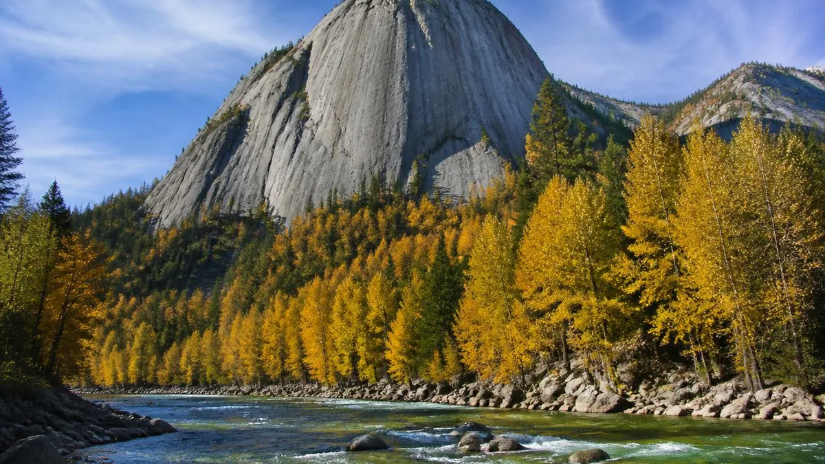
Two generations are distinguished. Hercynian granite and granodiorite, dated around 299 million years, weather into peak clusters, spires, domes and tors. Younger porphyritic biotite granite, around 145 million years, produces bell, cone, dome and high-wall forms with narrow slot valleys between them. Specialists have proposed naming the style Altai-type granite geomorphology, precisely because it does not resemble Huangshan or Hua Shan.
The exhibit is Shenzhong Shan, the Sacred Bell Mountain, also recorded as Amirsala: a single granite mass on the south bank shaped like an upturned bell, its relative height given as 351 metres in one source and 365 in another. Along the gorge, guides count 108 peaks. Look closely at the faces for two textures—dense honeycomb pitting, and vertical grooves that read like a frozen waterfall.
Scale is quoted loosely too. The Irtysh Grand Canyon is described as nearly 100 kilometres long in some accounts and just over 70 in others. The developed core, locally the big east gully, is U-shaped, about 8 kilometres long with a floor 10 to 40 metres wide, and the shuttle run out to the Shenzhong Shan terminus is roughly 20 kilometres.
Cold as a design constraint
The cold here is not atmosphere; it is the condition under which everything above was done.
The number in every brochure is −51.5°C, and it needs one correction: it belongs to the Fuyun county station, set on 21 January 1960, and it stood as Xinjiang’s extreme minimum until 18 February 2024, when a station in Turhong township in the same county recorded −52.3°C. Koktokay’s own claim on the record is a simplification, not a fabrication.
The “second pole of cold” label has a story behind it: water-department readings near −60°C were taken locally but not accepted, and Mohe in Heilongjiang took the national title. Winter runs from October into March or April, and −40°C is unremarkable in it.
Planning follows from that. Ürümqi is roughly 600 kilometres and about seven hours away. Allow four hours for the gorge and two for the mine park, and take the museum first, the pit rim second, the adit third—the history makes the hole legible rather than the reverse. A 2025 combined ticket with shuttles was reported at 223 yuan, but every figure here moves: confirm at the gate, and carry a jacket in July.
Stand on the rim and count the benches
Before you leave the pit, give the wall two minutes.
You are looking into the space a mountain used to occupy. The benches spiralling down are one record; the rock bands they cut across are an older one, and both run outward from the core. A melt sorted these elements out of a granite body around 220 million years ago, concentrating what nothing else could use into a ring. Then, inside about thirty years, a workforce that was not on any map sorted them again and shipped them to a Soviet ledger and a weapons programme.
A pop song in 2020 made the name famous nationwide, written by a composer who by his own account had never been here, and the visitors who followed it came for a love story the place does not really have. The story it does have is stranger. The water in the bottom of the pit stands where the summit was, and the summit is gone because six elements refused to fit into ordinary crystals.
The LoreLens app can help you identify pegmatite zoning, granite weathering forms and fault-rupture landforms while explaining the geology around them.
Location profile
Where it is

Frequently asked questions
Did the Koktokay mine really repay China's debt to the Soviet Union?
Partly, and the famous percentage is not reliable. What is documented: China owed the USSR loans and interest that Zhou Enlai's 1964 government work report put at 1.406 billion new roubles, roughly 5.29 billion yuan, to be cleared by 1965; a tonne of rare-metal concentrate was worth many tonnes of farm produce, so the state switched from agricultural goods to minerals, and Koktokay carried the export task. What is not documented: the share. You will see one third, 38, 40, 47 and 50 percent, none with a citable archive behind it. Archival work by the historian Shen Zhihua also finds no record of Soviet pressure to repay, and does find Soviet offers of grain and sugar in 1961, so the common framing that the Soviets demanded this particular pit as payment does not hold up.
Can you go down into the No. 3 pit?
No. Visitors see it from the rim, where the spiral haul benches and the water standing in the bottom are both visible. The underground experience is the Ayigoz adit, described as about 500 metres away and roughly 800 metres long, worked with hand tools and small machinery, cleared and lit for visitors from around 2015. It is cold inside even in summer, so carry a jacket. Whether the adit, the museum and the rim platform are all open on a given day varies, so confirm at the gate.
Is Koktokay the coldest place in China?
It is one of the coldest, but the record usually quoted needs a caveat. The figure of −51.5°C belongs to the Fuyun county weather station and was set on 21 January 1960; it stood as Xinjiang's extreme low until 18 February 2024, when a station in Turhong township in the same county reached −52.3°C. Mohe in Heilongjiang holds China's national record, which is why Koktokay is usually called the second pole of cold rather than the first. Winter here commonly runs from October into March or April.
How long do I need, and what else is worth seeing?
Two half-days is a workable minimum: roughly four hours for the Irtysh Grand Canyon and the bell-shaped granite peaks, and about two hours for the mine park, museum and adit. Kekesuli, a reed wetland ponded in the earthquake fault depression, takes another hour or so, and the Kalasangeer rupture site is a separate trip. A 2025 combined ticket covering the scenic area, the mine park and Kekesuli with shuttles was reported at 223 yuan, with single entry around 90 yuan plus 50 for shuttles, but prices, shuttle routes and opening hours change every season—confirm at the gate.
Sources and further reading
Background references for the history and place names in this guide. Opening hours, ticketing and access change often — always confirm with official local information before travelling.