Hebei · Chengde
Jinshanling Great Wall: Read the Ridge as a Fortress
Climb from restored battlements towards rougher watchtowers and learn how Jinshanling's ridges, barrier walls, inscribed bricks, soldiers and frontier communities made defence a system rather than a single wall.
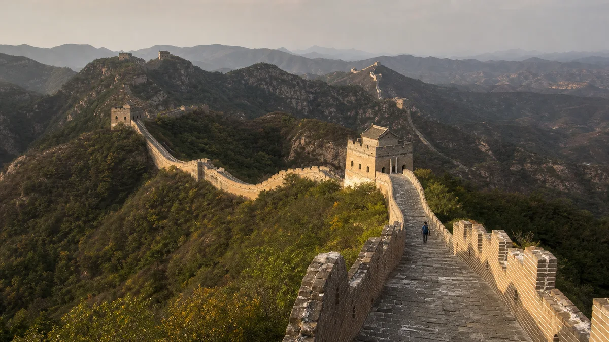
5A View location, maps and nearby scenic areasClimb onto the wall and stop before the first dramatic photograph. Look along the parapet: it falls into a saddle, rises towards a tower and disappears behind another ridge. At Jinshanling, the mountain decides what the masonry must do.
This Ming Great Wall section lies in Luanping County, Hebei, near Beijing. Here you can read a defence system adapting to gradients, blind spots, supply and people moving on both sides of the frontier.
Choose a turnaround point before climbing. Visitor maps compress height and may show neighbouring Simatai as if it were a continuous public trail. Begin at an operating entrance, confirm which towers and exits are open, and decide whether you will walk up and down, use a cableway if operating, or make a one-way hike with arranged transport.
A ten-kilometre ridge is not a ten-kilometre stroll
Visitor descriptions commonly give Jinshanling a length of roughly 10 kilometres and dozens of watchtowers. Totals vary with endpoints and how towers, passes and beacon positions are classified. Their density matters more: towers appear where terrain creates new tactical problems.
The Jinshanling Great Wall 5A profile establishes the Hebei location. On the ridge, distance becomes vertical: a nearby tower may require a descent and steep climb, while the return can be harder.
The line also belongs to a larger frontier network. Westward and eastward ridges connect conceptually—and in some places physically—to other managed or fragile sections, but a continuous historic wall is not the same as a legally open hiking route. Modern scenic-area boundaries, conservation closures and the Beijing–Hebei administrative line matter.
The wall follows military visibility, not a scenic contour
The wall uses ridges because height extends sightlines and makes an attacker climb. Towers occupy summits, saddles and changes of direction; passes control practical crossings; beacon communication connected a local alarm to a wider command system. The route is beautiful because the military logic is visible, not because Ming planners designed a leisure panorama.
Look for dead ground: a slope vanishes below the parapet while the next tower regains the view. Turns cover valley mouths, and steep rock sometimes replaces masonry.
Yet the Great Wall was never an unbroken machine that “kept everyone out.” Defence depended on troops, horses, weapons, supplies, signals, commanders and political decisions. Raids, migration, diplomacy, tribute, trade and licensed markets all crossed or reshaped the frontier. Walls delayed, observed and channelled movement; they did not end exchange.
Qi Jiguang strengthened a system he did not invent alone
Jinshanling is strongly associated with Qi Jiguang, the Ming general celebrated for coastal campaigns and later service in the northern Jizhou garrison. In the later sixteenth century, Qi and the command structure around him promoted stronger walls, hollow watchtowers, training and coordinated defence along this frontier.
Qi did not build every brick now called Jinshanling. Earlier works existed; projects involved court funding, commanders, engineers, military units, labourers and later repair. One heroic attribution hides the institutions and workers involved.
Qi’s importance is best understood as organisation. A tower mattered because a unit occupied it, signals were legible, relief could arrive and supplies reached the ridge. The masonry visible today is the durable remainder of a much larger system of drills, records, roads and human judgement.
Towers, barrier walls and bricks reveal adaptation
Jinshanling’s towers are not identical boxes. Windows, vaulting, platforms and entrances vary with position. They supported observation, signalling, shelter, storage or fighting; modern names do not always preserve one uncontested Ming label.
Notice short barrier walls set across or beside the main walkway. If an enemy gained the wall top, these transverse obstacles could divide the route and create another defended position. Parapets and firing openings also change according to which slope needed coverage.
Some bricks bear stamped or incised characters associated with production, military units or construction accountability. These “inscribed bricks” are valuable because they connect standard building material to administration and labour. Do not touch, rub, chalk or trace them for a clearer photograph; weathered marks lose information through repeated contact.
Soldiers and residents kept the ridge alive
A tower needed rotating soldiers, officers, signal teams and people responsible for weapons and repair. Grain, water, fuel, clothing and animals came from valleys where cameras rarely point.
Military households, farmers, porters, craftspeople and nearby communities supported the frontier. Some cultivated land allocated to feed garrisons; others transported supplies or maintained roads. Their lives mixed obligation, opportunity and risk rather than fitting a clean division between “army” and “local people.”
People north of the wall were equally diverse. Reducing them to a single timeless enemy erases Mongol polities, families, traders and shifting alliances. The Ming frontier alternated between violence and exchange. Read the wall as evidence of anxiety and organisation, not proof that two worlds never met.
Restored and rough fabric require different attention
Repaired sections make the wall safer and its military form easier to recognise. Repointed brick, rebuilt parapets and regular steps help visitors see the intended profile. Restoration is not deception, but neither should new surfaces be presented as untouched Ming material.
Rougher stretches expose collapsed courses, plants and irregular stone. Visible decay can feel “authentic,” yet loose masonry, erosion and visitor pressure destroy evidence.
Stay on the officially open line and behind closures. Do not step onto crumbling parapets, remove a brick or make a shortcut down the slope. Compare mortar, brick colour and wall edges from a safe distance; the transition between interventions teaches more than treating the least maintained area as an adventure playground.
Build the hike around effort, not tower count
A short first visit can ascend from a central operating entrance, reach the ridge, cross several towers and return before fatigue changes judgement. When running, the cableway may reduce the initial climb, but it does not remove steep wall sections or guarantee an easy descent.
A longer ridge walk should have a fixed turnaround time, water, sun protection and a known exit. Eastward views towards Simatai are celebrated, but do not assume the inter-scenic-area crossing is open. A locked boundary gate can turn a one-way plan into a dangerous late return.
Steps vary from repaired treads to high, narrow rises. Wind, rain, ice, lightning, heat and fog change difficulty quickly. Travellers with limited mobility should ask about entrance gradients, cableway boarding, tower thresholds and toilets. Pole tips must not damage masonry.
Photograph layers and protect your footing
Use a moderate or long lens to compress repeating towers across ridges; it reveals the communication network better than an ultra-wide view that makes every tower look tiny. Include a person at a safe distance for scale, and use side light to show brick texture when conditions allow.
Sunrise, sunset, autumn foliage, snow and clear horizons are never guaranteed. Special-hours entry may require a separate product, guide or registration. Confirm when and where you must leave; do not hide on the wall after closure for a shot.
Pack the camera on steep descents, yield at narrow passages and avoid loose edges. Drones may breach heritage or airspace rules; obtain current permission. A long lens reaches distant towers more safely.
The wall channels history; it does not seal it
At your turnaround, look beyond the crenellations. The same valleys that exposed an approaching force also carried envoys, merchants, migrants, farmers and supplies. Jinshanling’s wall made movement visible and controllable; it could not make the frontier socially empty.
This is why the section matters. The ridgeline holds Ming military engineering, but also restoration choices, present tourism and the labour of people usually absent from heroic portraits. Its broken and repaired surfaces are not competing versions of the past; together they show how defence became heritage.
Shanhai Pass explains how the Great Wall met a major corridor near the sea. Chengde Mountain Resort reveals how the later Qing managed northern relationships through court mobility as well as force, while the Eastern Qing Tombs turn mountains into ancestral order. At Jinshanling, leave before fatigue erases attention, and let the wall remain a route through history rather than a claim that history stopped here.
LoreLens App can help distinguish towers, barrier walls and inscribed bricks while connecting them to the soldiers and supply systems behind the masonry.
Location profile
Where it is

Frequently asked questions
How long should I allow for Jinshanling Great Wall?
Allow at least half a day for the ascent, a meaningful ridge section and the return. A longer hike needs a full day plus dependable transport. Distance on a map understates repeated climbs, photography stops and heat or wind. Confirm the open route and last descent before choosing a turnaround tower.
Is Jinshanling easier or quieter than Badaling and Mutianyu?
Jinshanling is often less concentrated and more hiking-oriented, with a striking transition between repaired and rough fabric. It is not automatically quiet or easy: weekends, events and photo seasons can be busy, while steep grades make short distances demanding. Choose by fitness and current access rather than reputation alone.
Can I use a cable car or continue walking to Simatai?
A cableway commonly serves part of Jinshanling, but weather, wind, inspection and maintenance can change operation. Do not assume the historic eastward hike continues through to Simatai; boundary gates and connecting paths may be closed or separately managed. Confirm both the ascent and legal turnaround route on the day.
Can I enter for sunrise, sunset or fly a drone?
Special photography sessions or extended-hour products may sometimes be offered, but normal admission does not guarantee access before sunrise or after the standard exit period. Weather and visibility are also unpredictable. Drone and tripod rules can change because of safety, heritage and airspace controls, so obtain explicit current permission rather than relying on older posts.