Jilin · Changchun
Jingyuetan: How a Reservoir Became Changchun's Forest
Find the ruler-straight dam or a row of evenly spaced trunks, then follow lake edge and forest to understand how water engineering, decades of planting and urban recreation made this landscape.
5A View location, maps and nearby scenic areasStand where you can see either the reservoir dam or a dense row of trunks. Close one eye and move sideways. The dam holds a ruler-straight line against the water; in the forest, one trunk disappears precisely behind another. Those alignments are the first clue to Jingyuetan: much of the landscape was deliberately built and planted.
Now turn towards the curved shore. Water, wind, leaf litter and decades of growth have softened the geometry. Birds and understory plants do not care whether a surveyor once drew the first line. Jingyuetan is therefore neither untouched wilderness nor an artificial stage with no ecological life. It is a made landscape that has continued to change.
Read the park in three pieces: the dam and reservoir edge explain water engineering; selected forest roads and trails reveal the plantation’s changing ecology; the winter recreation area has its own tracks and operations. A shuttle, bicycle or ropeway may cover one piece, but none should be assumed to complete the whole map.
A poetic lake name rests on a concrete dam
Jingyuetan is often translated as “Clear Moon Lake” or “Pure Moon Pool,” a name associated with the reservoir’s curved outline. The poetry can disguise its age. This is not an ancient glacial lake. Planning surveys began in 1933, dam construction started in 1934, and the reservoir entered water-supply service in 1936, according to commonly cited project chronologies.
The dam intercepted a small valley stream south-east of the urban centre. Contemporary plans described a water surface of roughly 4.3 square kilometres and storage in the tens of millions of cubic metres. Those are design-era figures, not a guarantee of today’s visible waterline. Reservoir levels shift with inflow, management, season and measurement method.
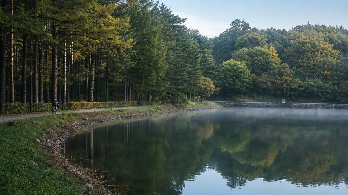
Look for the difference between a reservoir and a natural basin. The dam creates one unusually straight edge; coves follow tributary valleys; exposed shore may widen when water is lower. A reflection photograph records current conditions, while the landform records the engineering choice that made a lake possible.
The Jingyuetan 5A profile and map gives a useful location anchor. It should not be read as proof that reservoir, forest farm, scenic area, ski facility and every trail all share one boundary or ticket.
The water project belongs to occupied Xinjing’s history
In the 1930s, Changchun was renamed Xinjing, or “New Capital,” by Manchukuo, the Japanese-sponsored puppet state established in occupied northeast China. A rapidly expanded capital needed water, roads, administrative buildings and landscaped outskirts. Jingyuetan’s reservoir was part of that urban project, planned by the regime’s capital-building authorities with Japanese colonial expertise and institutions.
Calling it simply “modernisation” removes the political structure that decided what would be built and whom the new capital was meant to serve. Calling today’s park nothing more than a relic of that regime creates a different error. Manchukuo ended in 1945; Changchun and generations of residents, water workers, foresters and park staff subsequently inherited, altered and reinterpreted the reservoir landscape.
The people behind the infrastructure deserve attention even when many names are absent from a tourist map. Surveyors measured the catchment, labourers raised the dam, water workers maintained intake and flow, and forestry crews planted slopes to reduce erosion. Their tasks made the capital plan physical; later workers changed its purpose and ecological character.
For direct evidence of how imperial display operated inside the same occupation system, the Puppet Emperor’s Palace Museum belongs on a separate city visit. Jingyuetan reveals another scale of power: not a throne room, but the water and landscape infrastructure around a planned capital.
The forest was planted, and it still has to be managed
Afforestation accompanied the reservoir project because bare or heavily disturbed catchment slopes can send soil into stored water. Early forestry also served research and planned landscape goals. After 1945, planting, closure for regeneration and state-forest management continued across decades. The forest seen today is not one 1930s crop frozen in time.
Pine and larch stands are among the easiest plantation patterns to recognise. Trees of similar age may share height and spacing; a straight compartment boundary can meet another species abruptly. Elsewhere, broadleaved trees, shrubs, seedlings, fungi and fallen wood make the structure less regular. Wind, fire, pests, thinning and selective replanting continually revise the original grid.
A planted forest can provide shade, soil retention, carbon storage and habitat. It can also be vulnerable when large areas contain similar trees of similar age. Good management may involve thinning crowded stands, introducing or encouraging mixed species, protecting soil, retaining some deadwood where safe, controlling pests and creating firebreaks. A perfectly tidy forest is not automatically a healthier one.
Observe before naming. Compare bark, needles, cones and the plants below rather than calling every evergreen “pine.” Do not enter a closed compartment to improve the view. Forestry work, habitat protection, falling branches or fire risk can all explain a barrier that seems inconvenient from a leisure path.
The impressive numbers measure different Jingyuetans
You may encounter an area around 83 square kilometres, a rounded destination closer to 100 square kilometres, or an even larger “forest sea” description. Forest cover may be quoted above 80 percent in one source and above 90 percent in another. These numbers are not automatically fraudulent, but they are not automatically comparable.
One total may refer to the state forest farm, another to a scenic or protected boundary, another to a broader catchment. A forest-cover calculation changes when reservoir water, roads, lawns, buildings or buffer land move in or out of the denominator. Historical water-surface figures do not equal today’s whole park area.
Trail claims require the same discipline. A brochure may count a single race course, a signed leisure loop, paved roads, every forestry track, or the sum of several routes. The shoreline length is not the walking distance if coves, closures and access controls interrupt it. Ask for a current route map with named junctions rather than planning from the largest published kilometre total.
Scale still matters. Jingyuetan is large enough that a distant attraction on the same park map can require substantial time or a different transport segment. The honest conclusion is not “the figures are meaningless,” but “every figure needs a boundary, date and measurement purpose.”
One watershed must serve water, wildlife and visitors
The reservoir and forest form a catchment: rain and snowmelt move downslope through soil, ditches and tributaries towards the lake. Litter, eroded shortcuts and pollutants do not remain where they are dropped. Staying on durable paths protects more than a photogenic patch of ground; it helps limit sediment and waste moving towards the water.
Decades of vegetation create habitat for ordinary woodland birds, insects and small mammals, while the lake edge supports a different community. Biodiversity should not be measured only by a promotional species count. Seasonal migrants, understory regeneration, fungi and decomposers are part of the system even when they do not appear on a wildlife poster. Observe quietly, do not feed animals and leave plants and fallen wood where they belong.
Tourism brings income, public appreciation and reasons to keep urban land green. It also adds traffic, noise, compacted soil, wastewater, food litter and pressure for more facilities. Managers must balance recreation with water quality, forestry and habitat, while nearby residents need access, work and usable public space. No single slogan—“pure nature” or “theme park”—captures that negotiation.
Fire is the clearest shared risk. Dry spring wind, autumn litter or prolonged rainless periods can turn one flame into a forest emergency. Follow seasonal bans on smoking, cooking, incense, fireworks and open fire; do not assume a paved viewpoint makes a flame safe. Temporary forest closures and fire patrols protect both planted stands and the lives around them.
Vasaloppet gave managed winter a modern echo
Since the early 2000s, Jingyuetan has hosted a Chinese Vasaloppet cross-country ski event, linking Changchun to the long-distance skiing tradition that began in Sweden. The borrowed name is useful precisely because it shows cultural exchange rather than ancient continuity: a twentieth-century reservoir forest became a stage for a twenty-first-century winter identity.
Skiers, course groomers, snow crews, volunteers and spectators animate a different park from the summer lakeside. A groomed track turns plantation corridors and rolling terrain into a route through endurance sport. The event helped make winter something to organise and share, not merely a season when the park was inaccessible.
It does not prove that snow is deep, natural or skiable everywhere on a fixed date. A race may use managed snow, altered courses and controlled crossings. Event schedules, public ski tracks, equipment rental, ropeway operation and spectator zones can change with temperature, snowfall, maintenance and safety decisions.
Treat the reservoir ice separately. Even prolonged cold can produce variable thickness near inflows, outlets, springs, structures or pressure cracks. Enter only an ice area explicitly opened and monitored for visitors. A blue-ice photograph online is not a site-specific safety inspection for the day you arrive.
Choose a dam loop, a forest route or a winter zone
For a first, compact visit, begin with the main visitor area, identify the dam line and water level, then add one lakeside section and one plantation path. This sequence explains origin, water and forest without pretending to cover the park. Three or four unhurried hours can be meaningful when the correct gate and current circulation are confirmed.
For a forest-focused half or full day, choose a named loop or an out-and-back trail with a clear turnaround. Let one regular stand, one more varied understory and one shoreline view provide comparison. Forestry roads that appear on a digital map may be closed to leisure use; download the current visitor map and do not improvise through a compartment.
For a cycling visit, confirm where bicycles are permitted, whether rentals are available and whether a return transport option exists. Roads shared with shuttles or service vehicles demand conservative speed. “Around the lake” may be a product name or event distance rather than one continuous waterfront cycleway.
For winter recreation, go directly to the operating ski or snow zone rather than adding it casually to a full lake walk. A shuttle or ropeway, when running, serves particular stops or slopes, not every cove and trail. Tickets and operating hours may be separate. Ask which gate is closest to the activity before leaving central Changchun.
Match access and safety to the exact segment
Broad paving near a principal entrance or dam can offer the gentlest version of Jingyuetan, but a level-looking map hides gradients. Bridge approaches, rough forest paths, steps, long distances and shuttle boarding can break a step-free route. Wheelchair users and visitors with limited stamina should request a current accessible loop with specific toilets, rest points and boarding arrangements—not a general assurance that “the park has vehicles.”
Transport systems solve different problems. A sightseeing shuttle covers road distance. A bicycle gives independence only on permitted surfaces. A ropeway, when open, may reach a recreation viewpoint but does not create access to the full reservoir. Confirm whether mobility devices can be carried and whether a companion can remain together through each transfer.
In summer, carry water, sun protection and insect repellent. Thunderstorms can arrive quickly over exposed water; leave viewpoints and avoid isolated tall trees when warnings or thunder begin. After rain, roots and wooden surfaces become slippery. Never shelter inside a closed forestry work zone.
In winter, wear insulated footwear with grip and expect cleared routes to differ from the summer map. Snow can conceal kerbs, drainage channels and ice. In dry or windy seasons, observe fire-control notices. At all times, do not cross a closed gate, enter water infrastructure, or step onto unapproved ice simply because other visitors have done so.
Photograph the design, then leave the landscape intact
Make the first photograph about a straight line: align plantation trunks, place the dam across the frame, or let a forestry road vanish between even rows. Then turn ninety degrees and make the second about a curve: shoreline, cove, branch or reflection. Together, the images explain construction and natural process better than one saturated lake view.
People supply scale, but ask before making anyone identifiable. A walker between trunks shows spacing; a cyclist on an approved road shows distance; a worker at the dam reminds us that the landscape still requires maintenance. Reflections depend on light, water level and wind, so do not enter mud, reeds, closed forest or ice to force symmetry.
Continue through modern Changchun by contrast. Changchun Movie Wonderland turns screen culture into managed entertainment; Changchun World Sculpture Park places curated art inside another designed landscape; the Puppet Emperor’s Palace Museum confronts the occupation system in which Xinjing’s infrastructure expanded.
Before leaving, return to the first straight row of trunks or the dam crest. Its geometry is still visible, but roots have shifted soil, branches have competed for light, and weather has redrawn the water’s edge. Nature made by people is not less deserving of care. It is more demanding of honesty: understand what was built, under what power, by whose continuing work—and protect the living landscape it has become.
Use the LoreLens App at Jingyuetan to recognise the dam, forest patterns and winter facilities, then hear how engineering and ecological change share the view.
Location profile
Where it is

Frequently asked questions
Is Jingyuetan a natural lake and ancient forest?
No. The lake is a reservoir built for Changchun's water supply in the 1930s, and much of the surrounding forest developed through organised planting and long-term management. That constructed origin does not make the landscape ecologically empty, but it should not be marketed as untouched primeval nature.
How much time should I allow for Jingyuetan?
Three or four hours can cover a focused dam, lakeside and nearby forest route. A full day is more realistic for a longer forest walk, cycling where permitted, or a separate winter-sports area. The park is too large to treat every attraction as one compact circuit, so choose a priority zone and gate.
Can I walk or cycle all the way around Jingyuetan?
Do not assume there is one continuously open, fully signed circuit matching the apparent shoreline on a map. Published distances may describe different roads, trails or event courses. Bicycle access, rentals, shuttles and closed forest sections can change, so confirm the current route and turnaround point at the entrance.
Can visitors ski or walk on the frozen reservoir in winter?
Only use officially opened and managed winter facilities. Natural snow, groomed ski tracks, equipment rental, events and ice access vary with temperature and operations. A frozen-looking reservoir is not proof that its ice has been tested for public access; stay off unless the scenic area clearly designates a route.