Xinjiang · Qitai
Jiangbulak: Wheat That Grows on Rain Alone
Two hundred thousand mu of unirrigated mountain wheat on the north flank of the Tianshan, a Han fortress that is probably the Shule City of the Hou Hanshu, a replica of that fortress you can actually walk into, and a famous slope that is an optical illusion.
5A View location, maps and nearby scenic areasAlmost everything about the northern flank of the Tianshan argues against rain-fed farming. This is the edge of the Junggar Basin, deep inside a continent, where agriculture normally means a canal from a snowmelt river and a careful argument about who gets the water in May.
And then there is a hill belt in Qitai County, east of Ürümqi and then up, where wheat covers the slopes to the horizon and nobody irrigates any of it. The name is Kazakh and is usually glossed as the source of sacred water. The interesting part is the water that arrives from above rather than the springs it is named for.
Why wheat grows here without a canal
The mechanism is orographic, and once you know it you can read it off the landscape. Chinese accounts of the local farming system describe moist air moving in over the basin, running into the range and being forced upward; as it climbs it cools, and it rains on the hill belt in quantities the desert below never sees. The spruce forest above then acts as a reservoir, its roots holding water in the soil rather than letting it run off. Below the forest, the wheat.
Two secondary conditions matter as much as the rain. The first is relief: the fields sit mostly around 1,700 metres on rolling ground with 50 to 150 metres between crest and hollow and slopes near 20 degrees—steep enough to drain, gentle enough to hold a seedbed and to take machinery. The second is the inversion belt. Here the winter air is warmer than the basin floor below, because cold air pools downhill, which makes the mid-mountain band the mild one.
That is why the county’s land use stacks by elevation: pasture high up, rain-fed grain on the hills, snowmelt-irrigated fields on the plain. Qitai’s roughly two million mu of arable land is described in exactly those three bands. The wheat you are photographing is the middle one.
They are not terraces, and the difference is visible
Foreign copy tends to call these terraces. They are not—no built risers, no stone retaining walls, none of the cut-and-fill benching you see at Longji or in the Philippine cordillera. Chinese sources avoid the word too; the local terms translate as hill dryland or slope field.
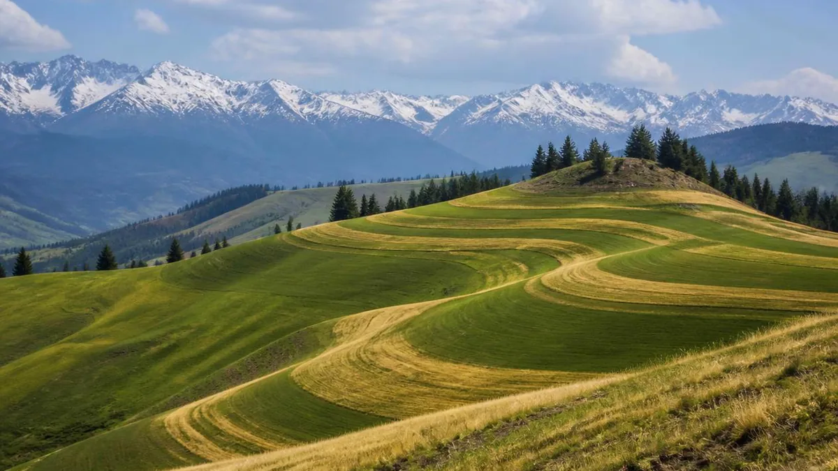
What creates the terrace effect is that sowing and cutting follow the contour, so bands of crop at slightly different stages of ripening wrap the hills in stripes. The stripes are agronomic, not architectural: a working pattern redrawn every year, not an inherited structure.
The traditional practice recorded for this system reinforces the point: ploughing by a two-ox single-beam rig, broadcast sowing techniques whose names translate roughly as rolling the water and waving the seedlings, rotational fallow to hold fertility, and heaping and burning grass followed by deep drilling against pests. And a paired land use—crop planting followed by grazing on the stubble—which is the hinge between the farmers and the herders above them.
The calendar of a field that nobody waters
Rain-fed spring wheat runs a tight schedule, and the visitor calendar follows it rather than the reverse. Seed goes onto the slopes in spring and the hills green up as it emerges. Wildflowers peak roughly from mid-June to the end of July, with Chinese guides narrowing the best of it to the turn of the month. The golden phase—the wheat wave with snow ridges behind it—is generally described from around mid-July. Harvest reporting in recent years lands in the second half of August, with small and medium combines working the slopes; one account puts completion between late August and early September. Then the stubble fills with animals, and by winter the belt is under snow.
Two variables you cannot control. Elevation staggers ripening, so gold in the lower fields may run a week or two ahead of gold higher up. And this is rain-fed grain: a wet year gives full, heavy ears, a dry one does not, and the same variability moves the dates. County extension staff have been quoted on exactly that relationship between rainfall and grain fill.
A farming system with a certificate
This is not simply a scenic wheat field. In 2015 the Qitai dryland farming system was recognised as a China Important Agricultural Heritage System, and the county has been pursuing the global equivalent.
The scale is worth stating properly. The recognised system spans six townships—Banjiegou, Dongwan, Jibuku and Qihu among them—and totals about 200,000 mu, essentially all rain-fed, growing wheat, barley, buckwheat and various vegetables and fruit. Jiangbulak is the largest continuous block inside it, commonly given at around 20,000 mu, which is why it became the shop window. The wheat here carries the nickname first granary of the Western Regions.
The historical depth is real but needs care. Chinese material dates farming here to two millennia and describes military colonies expanding after the Tang established the Beiting Protectorate, with settlers opening dryland fields on the hills. Lin Zexu, passing through during his exile to Xinjiang, is quoted with a couplet about a place where they neither weed nor manure and simply scatter the seed and leave it to heaven. These are attributions from later compilations rather than excavated agricultural evidence, so read the two thousand years as a claim about continuity of land use, not as a dated field.
Shichengzi, and the siege in the Hou Hanshu
Inside the scenic area, above a ravine near Magouliang village in Banjiegou township, stands a rectangular earthwork: the most important Han-period site excavated in Xinjiang.
The plan is about 280 metres east to west by 380 metres north to south, roughly 110,000 square metres, built to the slope with the high ground at the north. North and west walls survive; the east and south sides needed none, because deep ravines do the work. There is an inner citadel in the north-west corner, a gate mid-way along the west wall, rammed-earth walls 8 to 9 metres wide at the base with up to 3 metres standing, corner towers, two bastions on the north wall, and a moat outside the west wall. The site sits near 1,749 metres.
Found in a county survey in 1972, it was excavated systematically between 2014 and 2019 with remote sensing, ground-penetrating radar and electrical and magnetic prospecting. More than 2,000 objects came out, mostly building material: mould-made flat and tube tiles and tile ends carrying cloud, deformed-cloud and geometric designs of unmistakably Han workmanship. Weapons and iron armour plates came out in quantity too—what you expect of a fortress, not a town. Archaeologists describe it as the only Han site in Xinjiang with a reliable date, a substantially complete plan and a clear cultural character, and as the largest Han military fortress excavated in the region.
Then the identification. Radiocarbon results plus the finds, read against the histories, led the excavators to conclude the site is basically confirmed as the Shule City of the Hou Hanshu biography of Geng Gong. In 75 CE, with the Wu and Ji colonels holding positions north and south of the range, Geng Gong moved his troops to Shule because, in the histories’ phrase, it had a ravine stream beside it that could be held. The Magou River still runs in that ravine. Besieged by a Xiongnu force put at more than twenty thousand, with no grain and no relief, his men boiled the sinew and leather off their armour and crossbows for food; twenty-six were alive when help came, and thirteen reached Yumen three months later.
Note the register the archaeologists use: not “this is Shule” but “basically confirmed”—a strong identification, honestly labelled. The site became a national key protected site in 2013 and one of China’s top ten archaeological discoveries for 2019.
The Shule City you can walk into is a film set
Here is where visitors get confused, so be blunt about it. The walled city with barracks and a tavern listed among the scenic area’s attractions as Han Shule City is a reconstruction, built to Han military specification on the site of a former film base used for a production about the thirteen surviving soldiers. Since May 2026 it has hosted a large immersive performance in the 5A core area, staged with the Tianshan as backdrop.
The real ruin is Shichengzi, and its own protection-and-display project only started in May 2025, with plans for artefact displays, an exhibited excavation trench and multimedia reconstruction. Until that matures, treat the ruin as a protected site rather than an attraction: what is accessible, when and on what ticket is a question for the scenic area or the county cultural-tourism office.
None of which makes the replica worthless. A rebuilt frontier fort is a legitimate way to understand a plan you cannot read from an eroded earth bank. It just is not the earth bank.
The Cheshi Ancient Road does not start here
The second common conflation is a road. Itineraries and travel posts regularly present the Cheshi Ancient Road as starting from Jiangbulak. It does not.
The route described in Chinese sources begins at the Jiaohe ruins near Turpan, crosses stony riverbeds and steep tracks, climbs the perennially snow-covered Qiongdaban at about 3,400 metres, and runs close to 200 kilometres over the range to Quanzijie township in Jimsar County—the next county west, not this one. It is named for linking the two states of Cheshi, and Tang sources call it the Tadi road.
What is true is better than the marketing version. Several trans-Tianshan routes existed, and two of them—named in Chinese accounts as the Wugu and Sahan roads—ran near Shichengzi; from the fortress one could cross the range and reach Liuzhong, which is why the Han garrisons north and south could support each other at all. The confusion is helped along by a tourism programme that picked ten ancient routes out of sixty-four and strung Heavenly Lake, Jiangbulak, the Flaming Mountains and Grape Valley along them—a product line, not a road.
One more trap: a reconstructed Shule City also exists inside the Cheshi Ancient Road scenic area, several counties away. Two replicas, one ruin, one name.
The gravity hill is an illusion, and a good one
One of the scenic area’s five zones is a slope where a vehicle in neutral appears to roll uphill and water appears to run the wrong way. It is worth ten minutes, and worth knowing what you are looking at.
These are known internationally as gravity hills, and there are hundreds; Chinese sources count more than ten in the country. The explanation is consistent everywhere it has been tested: a genuine but very slight downhill grade, plus a missing horizontal reference, plus “vertical” objects that are not vertical. Where the horizon is broken by surrounding slopes the eye has nothing to calibrate against, and leaning roadside trees and posts reset the brain’s idea of level. At one Chinese gravity hill a plumb line showed the stone pillars leaning about five degrees; at another, surveyed every five metres, the supposed bottom of the slope proved 1.395 metres higher than the top across seventy metres—a two percent grade, downhill, the opposite of what visitors saw.
The alternatives fail on measurement. Gravity readings at these sites are normal, ruling out mass anomalies and buried ore; scale models reproduce the illusion in a laboratory, which disposes of magnetism. Chinese science writing notes the awkward incentive too: operators tend to prefer an unsolved mystery.
So enjoy it as perception rather than physics. It demonstrates that your sense of level is inferred from context—a genuinely strange thing to learn on a hillside.
Above the wheat, the pasture is a workplace
Climb past the last field and the system continues. The scenic area spans roughly 1,500 to 3,800 metres, averaging near 2,200, crossing seven vertical landscape zones; above the crop belt come meadow, conifer forest and high grassland—the local name for the top translates as sky grassland.
That ground is Kazakh summer pasture, and its relationship with the fields below is not decorative. Forage at different elevations peaks at different times, so moving animals is how a household gets a full season without exhausting any one band; and here the cycle closes with the harvest, because cut wheat leaves stubble that stock can use. Farmers and herders in this system are described as interdependent, not merely adjacent.
The landform frame is worth noting from the boardwalks: a canyon running some 15 kilometres at around 1,900 metres, wheat on its eastern side and a narrow ridge on its western, a 4,000-metre peak beyond. The designations stack up too—national forest park in 2003, 4A in 2012, national 5A in July 2022 as Xinjiang’s seventeenth, over a stated 121 square kilometres with a 48-square-kilometre core.
Find the line where the wheat stops
Before you leave, pick a viewpoint and find the upper edge of the wheat.
It is a soft line, and it moves from field to field, but it is legible: gold below, then meadow, then dark spruce on the shaded aspects. That boundary is not a property line or a planning decision. It is the altitude at which the growing season becomes too short for grain and grass takes over—the same arithmetic of moisture and warmth that puts spruce on one wall of a valley and not the other, drawn on a bigger canvas.
That is the thing to carry out of Jiangbulak. Not that the wheat is photogenic, which you will have established in the first ten minutes, but that a rain-fed grain belt at 1,700 metres inside a desert continent is a narrow accident of slope and prevailing wind—and that people worked out how to farm it, and how to graze what was left, long before anyone explained the mechanism to them.
The LoreLens app can help you identify Schrenk spruce, alpine meadow species and dryland crop patterns here while explaining the geography that makes them possible.
Location profile
Where it is

Frequently asked questions
How can wheat grow here without irrigation, in one of the driest regions in China?
Because the fields sit on the windward mid-slope of the Tianshan rather than on the basin floor. Chinese accounts of the Qitai dryland farming system describe moist air arriving over the Junggar Basin, meeting the range, and being forced to rise and cool, which produces far more rain on the hill belt than on the desert below; the spruce forest above holds that water in its root zone. The wheat sits mostly around 1,700 metres on rolling hills with 50 to 150 metres of relief and slopes near 20 degrees, so runoff is slow and the soil profile stays wet enough for a spring crop. Locals summarise it as borrowing rain from the sky, and the phrase for the fields translates roughly as dry land that is not dry.
Is the Han fortress here really the Shule City where Geng Gong held out?
The identification is strong but stated carefully by the archaeologists themselves. The Shichengzi site, inside the scenic area near Magouliang village, was excavated between 2014 and 2019; radiocarbon dating plus the finds place it in the Han period, and the excavators concluded it is basically confirmed as the Shule City of the Hou Hanshu account of Geng Gong. The supporting points are physical: a cliff-edge plan with the high point commanding the approaches, an inner citadel against the north and west walls, corner towers, bastions and a moat, and a ravine stream that matches the phrase in the histories about Shule having a stream beside it that could be held. It was made a national key protected site in 2013 and named one of China's top ten archaeological discoveries for 2019.
So is the Shule City that visitors tour the real archaeological site?
No, and this is the mix-up worth carrying with you. The walled city, barracks and tavern that visitors walk through were built to Han military specification on the site of a former film base, and now host a large immersive performance staged in the 5A core area from May 2026. The genuine ruin is Shichengzi, a national key protected site whose own protection-and-display project only began in May 2025, so what is open there, whether the excavated ground can be entered, and whether a separate ticket applies should be confirmed with the scenic area or the Qitai cultural-tourism authority rather than assumed.
When does the wheat turn gold, and when is it harvested?
June to September is the usable season overall. Wildflowers peak roughly from mid-June to the end of July, the fields read as green through June, and Chinese material describes a golden wheat-wave season from around mid-July. Harvest reporting in recent years falls in the second half of August, with small and medium combines working the slopes and one account putting completion between late August and early September; after cutting, the stubble becomes grazing. Elevation and the year's rainfall both shift the dates, so treat any single week as an estimate and check locally before booking around it.
Sources and further reading
Background references for the history and place names in this guide. Opening hours, ticketing and access change often — always confirm with official local information before travelling.