Shanxi · Linfen
Hukou Waterfall, Shanxi: Reading the Yellow River
Stand on the Yellow River’s east bank as a broad, sediment-rich current contracts into a rock trench—and plan for a waterfall whose view, access and danger change with the river.
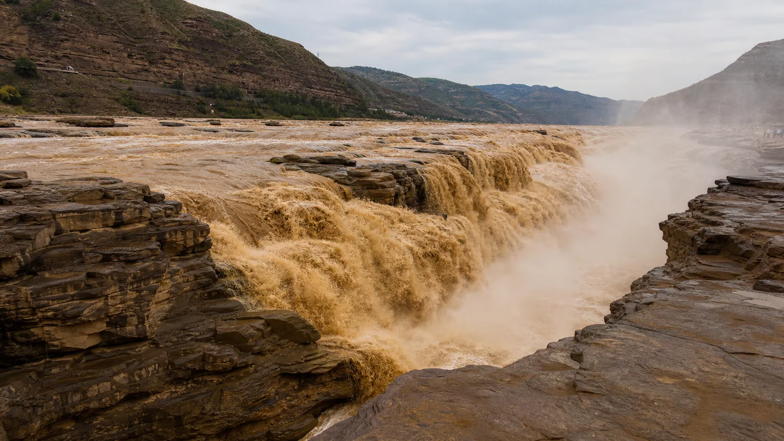
5A View location, maps and nearby scenic areasStand first where the broad Yellow River begins to lose its width. Upstream, yellow-brown water rolls across an open bed. Ahead, it gathers into folds, accelerates and drops into a narrow rock trench. The sound arrives through the ground as much as through the air; spray carries fine sediment onto railings, clothes and lenses.
This guide begins on the Shanxi side, in Jixian County on the east bank. Across the river is Yichuan County, Shaanxi. Both banks face the same water, but they are not interchangeable attractions. Each has its own approach road, visitor management, ticketing, platforms and closure decisions. The fall line also shifts in appearance with discharge, so claims that one bank is always the “front” and the other always the “side” are too simple.
Plan around one bank unless you have ample road time: the Shanxi visit normally links a visitor centre and internal transfer with the main east-bank viewing zone. Lower or closer platforms, including any cave-like viewpoint, are conditional on river level and safety control. The province-specific Hukou Waterfalls 5A profile is the correct map anchor; use Shanxi-side notices for actual access.
One waterfall, two independently managed banks
The Yellow River forms the provincial boundary here. Shanxi’s managed area lies on the eastern bank; Shaanxi’s lies opposite on the western bank. From Shanxi, you generally look westward or obliquely downstream into the contraction and plunge. From Shaanxi, the direction reverses. Open platforms, barriers and water width determine how much of the lip, spray cloud and downstream trench each side can show on a particular day.
Do not choose by a viral “which side is better” verdict. The Shanxi side is often valued for proximity to the turbulent throat and a forceful oblique view. A lower viewpoint sometimes called Longdong, or Dragon Cave, has historically offered a view from nearer or below the fall, but it must never be treated as a standing feature: high water, ice, maintenance or safety works can close it. The Shaanxi side may offer a broader-looking composition from its own open platforms, but those too change with operations and flow.
There is no footbridge across the falling water. Visiting both sides means leaving one controlled area and driving through the regional bridge and road network to the other entrance. It can involve separate parking, shuttles, reservations and tickets. Confirm road status before attempting a two-bank day, especially during floods, winter weather and holiday congestion.
The “kettle mouth” is a narrowing river and rock trench
The name Hukou means “kettle mouth.” Official scenic interpretation describes a broad channel contracting sharply before water falls into a much narrower bedrock slot. Exact widths and drop heights vary among sources and with the point measured, so the mechanism matters more than a single tourist number: a large river is forced through a resistant, confined reach.
The exposed rock is not featureless. Local geological interpretation identifies Triassic sandstone and conglomerate with muddier layers, cut by near-vertical joints and near-horizontal bedding. Flow exploits these planes. Impact, abrasion by sand and gravel, pressure changes, weathering and block failure enlarge weaknesses. Rock fragments are then broken down or swept away.
Downstream, the narrow trench is commonly called the Shili Longcao, the “ten-li dragon trough.” The poetic distance should not be read as a surveyed length. Its useful geological meaning is a confined channel below the waterfall. As erosion removes support and blocks fail near the lip, a waterfall can migrate upstream over long periods. Proposed ages and retreat rates for Hukou differ by method and starting assumption; the landscape does not supply a reliable countdown from legend.
From a safe position, compare the broad upstream surface with the concentrated downstream slot. Look for joints, bedding, angular blocks and smoother water-worn surfaces. The drama comes from a changing boundary between rock strength and river power, not from a fixed stone stage.
Yellow water records a moving sediment system
Hukou’s colour comes largely from suspended sediment carried through the middle Yellow River. Rain falling on loess-covered slopes and tributary basins can deliver fine material to the main channel. The Yellow River Conservancy Commission has documented short-term rises near Hukou when middle-reach rainfall swells tributaries and sends sediment-rich water into the river.
Brown or ochre water is therefore not automatically evidence of a local pollution event, just as a paler flow is not proof of ecological purity. Sediment concentration, light, cloud, depth and upstream operations all alter colour. Foam can be produced by turbulent entrainment of air and natural organic material, though unusual odour, sheen or official warnings should still be taken seriously.
Sediment creates the famous visual mass, but it also abrades rock, fills and empties channel pockets, clouds aquatic habitat and settles where velocity falls. Dams and soil-conservation work elsewhere in the basin alter how much water and sediment arrive and when. Hukou is not an isolated natural tap; it is a pulse within a heavily managed river system.
Seasons offer tendencies, never a performance schedule
In spring, thaw and moving ice can transform the channel. “Ice breakup” does not mean a gentle decorative drift: slabs can jam, rotate and raise local water levels. In summer, monsoon rain and tributary inflow can produce rapid, sediment-heavy rises. Autumn may bring substantial flows in some years, but timing and volume vary. In winter, freezing can form shelves, icicles, mist ice and fragmented cover, while open water continues beneath or beside it.
Each condition trades spectacle for risk. Strong flow can widen the falling curtain and raise spray, yet close the lower bank or all viewing. Low flow may expose the rock throat and separate strands, making structure easier to read. Ice can reveal how spray reaches the walls, yet make every slope, rail and stone surface more dangerous.
Avoid calendar promises such as “the waterfall is fullest every October” or “January always has an icefall.” Basin rainfall, temperature, upstream releases and safety management do not follow travel advertising. The Shanxi official site explicitly notes that some routes open and close according to Yellow River conditions and warns about sudden rises and ice-flood hazards. Check on the morning of travel, then accept that staff can change the decision after you arrive.
The Shanxi route should remain deliberately simple
For a focused visit, use the current designated transfer from the Shanxi visitor centre and walk the authorised main viewing line. Move from upstream to downstream if crowd control permits: first observe the broad approach, then the contraction, fall and narrow channel. This sequence explains Hukou more clearly than rushing directly to the loudest rail.
A longer Shanxi-side visit can add official interpretation, a more distant gorge view or nearby cultural stops if open. Do not add a lower cave or water-edge path until staff confirm it that day. A route printed on an older map, blog or ticket package may have been altered by flood damage, construction or new safety barriers.
Some official itineraries extend beyond the waterfall to sites such as Kenanpo, associated with the wartime headquarters and Shanxi provincial government presence in this region. That is a separate historical visit, not a second angle on the cascade. Give it its own time rather than compressing geology, wartime interpretation and staged performances into one hurried circuit.
Admission, internal transport, identity requirements, hours and last entry change. Carry the document used for a current reservation if required. Photograph the map and posted safety notice before boarding the shuttle, and leave a margin before final return rather than making the last vehicle your plan.
The riverbank is also a place of work and memory
Hukou is often presented as an emblem of national endurance. The roar and yellow surge have entered poems, songs, film and public education. The Yellow River Cantata, created during the war against Japan, helped make the river’s voice a modern political and emotional symbol. Its meaning belongs to twentieth-century history; it is not evidence for the geological age of the waterfall.
Long before scenic barriers, nearby communities managed difficult slopes, ferries, roads, farming and trade. The fall itself was an obstacle to navigation, not a thrilling rapid for ordinary boat passage. Boatmen, porters and travellers needed safer crossings and routes around dangerous reaches. Today local livelihoods include accommodation, food, guiding, driving, cleaning, performance, photography services, security and rescue.
Costumed photo scenes, folk music, drums or pack animals may be part of the visitor economy. Engage on clear terms, ask the price before a photograph, and do not present a staged costume as unchanging village life. Avoid crowding performers without consent. If animals are being used, do not support handling that appears distressed or unsafe.
Tourism concentrates both opportunity and pressure
5A status and national fame bring customers to Jixian and surrounding villages. Visitor spending can support employment, roads, interpretation and conservation. It also concentrates buses, waste, sewage demand, noise and construction near a fragile river edge. Spray does not wash those impacts away.
The safety boundary is also an ecological boundary. Stepping onto exposed rock for a cleaner image tramples small patches of vegetation, spreads people across unstable surfaces and normalises barrier crossing. Litter entering the river becomes part of a basin that communities downstream must live with. Carry waste out and reduce single-use rain covers, shoe covers and drink containers.
Water and sediment management across the Yellow River involves flood control, reservoirs, soil conservation, water supply and ecological goals that can conflict. A powerful waterfall view is one result among many, not the sole purpose of the river. Reading gauges, closure boards and repaired embankments alongside the spectacle keeps this managed reality visible.
Access begins with the correct province
Navigation apps may return two places with nearly identical names. For this guide, set the destination to the Shanxi / Jixian visitor centre, not the Shaanxi / Yichuan entrance. Verify the province in the booking platform, parking instructions and accommodation listing. “Hukou hotel” alone is not enough.
Roads approach through loess hills and the incised Yellow River corridor. Curves, heavy tourist traffic, fog, rain, frost, roadworks and temporary flood controls can extend the trip. Public and tourist buses may operate from changing hubs or only in certain seasons; confirm the return before leaving a rail station or city. Do not rely on an old timetable for a remote final connection.
For mobility-limited visitors, ask whether the current shuttle accepts wheelchairs, how far the stop is from the main rail, and whether gradients or steps interrupt the return. Main areas may be paved, but spray, silt and crowd barriers can make them difficult. Lower viewpoints are not realistic substitutes for an accessible platform. Accessible toilets and a visitor-centre service do not certify every viewing route.
Safety should decide where the photograph ends
Spray makes stone, metal and temporary mats slippery. Fine sediment coats shoes and hides uneven edges. Keep children between adults, do not sit or lean on rails, and never lift a child above a barrier for a photograph. The sound can mask instructions; watch staff signals as well as listening.
If water rises, ice begins moving, wind strengthens or staff clear a zone, leave immediately. A calm platform can become exposed to spray and debris after an upstream pulse. Do not descend onto newly exposed rock, enter the trench, approach an ice edge or shelter below an unstable overhang. The official warning about sudden water and ice flood deserves literal attention.
For a coherent image from Shanxi, include three parts: the wider approach, the contracting lip and a visible section of the downstream trench. A fast shutter freezes sediment-rich folds; a moderately slower exposure shows direction, but long exposures can turn dangerous water into harmless-looking silk. Stay stationary, use a strap, protect the lens between frames and never back toward the rail.
The east-bank orientation can place earlier light behind or beside the photographer and later light nearer the view direction, but cloud, season and platform angle change the result. A rainbow requires sun, spray and the correct geometry; it is never scheduled. Treat mist as atmosphere, not a reason to climb for an unobstructed frame.
Finish upstream of the drop. The river looks broad again, but now the surface carries more information: loess sediment from tributaries, water shaped by rainfall and regulation, energy about to be concentrated by a rock throat, and risk monitored by workers on both banks. Hukou is not one permanent curtain. It is a border, a changing river process, a place of labour and a national image—seen here, specifically, from Shanxi.
Continue through southern Shanxi with the migration memory at Hongdong Locust Tree or the ritual landscape of Yunqiu Mountain; follow the river north on the Shaanxi side through the great meanders of the Yellow River Qiankun Bend.
The LoreLens app can help you distinguish the Shanxi bank, the contracting channel, sediment pulses, ice features and visitor infrastructure without confusing one river state—or one province’s platform—with the whole of Hukou.
Location profile
Where it is

Frequently asked questions
Is this guide for the Shanxi or Shaanxi side of Hukou?
It is for the Shanxi entrance in Jixian County, on the Yellow River’s east bank. Shaanxi operates a separate visitor area on the west bank in Yichuan County. The two sides have different roads, tickets, platforms and closure notices; a ticket for one should not be assumed valid for the other.
What is the best season to see Hukou Waterfall?
No month guarantees a particular waterfall. Spring ice breakup, summer and autumn rain, upstream regulation, tributary inflow and winter freezing can all transform the width, colour and access. High water may look powerful but can close lower areas or the entire site. Check same-day river and scenic-area notices.
Can I visit both riverbanks on the same ticket?
Do not assume so. The Shanxi and Shaanxi areas are separately managed, and their viewing zones are not joined by a pedestrian crossing at the falls. Reaching the other bank normally requires leaving the site, using the regional road and bridge network, parking or transferring again, and following the other side’s ticket rules.
Is the Shanxi viewing area accessible?
The visitor centre, shuttle and some main paved viewing areas may reduce walking, but boarding steps, gradients, wet or uneven surfaces, crowds and temporary barriers remain. Any lower cave or close-to-water route is unsuitable for many mobility-limited visitors and may be closed. Confirm the current least-stepped return route before entering.