Xinjiang · Bogda
Heavenly Lake of Tianshan: The Dam Nobody Looks At
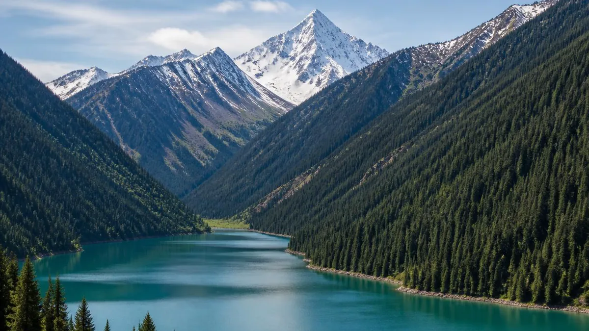
A glacier-dammed lake on the north flank of Bogda Peak, a name invented by a Qing official in 1783, a myth attached to it long afterwards, and a World Heritage component you are standing inside without being told.
5A View location, maps and nearby scenic areasThe lake that English maps call Heavenly Lake has carried that name for roughly two hundred and forty years. The mountain above it has been called four other things. The myth everyone repeats about it is older than both, and was almost certainly attached here late.
None of that makes the place less worth the drive. It makes it worth reading properly. This is a lake held in position by a pile of rubble on its northern shore, on the north flank of a 5,445-metre peak, above the small city of Fukang east and then south of Ürümqi—and almost everything interesting about it follows from the rubble rather than from the story.
The dam on the north shore is the whole story
Chinese surveys settle on a category: this is a moraine-dammed lake, sitting in the upper reaches of the Sangong River. The mainstream account stacks three processes. The valley was opened and deepened, glaciers scoured it into a trough, and then the debris a glacier pushes ahead of itself and abandons on melting back sealed the lower end. Water collected behind that plug.
The plug is not subtle. The barrier along the northern shore is described as a composite of terminal moraine and material collapsed off the slopes above, quoted at some 289 metres high and nicknamed locally the crocodile’s tail. Repeated geological traverses were run to settle what it is made of, and concluded the bulk is glacial deposit with bedrock rising to form a threshold on one side—a moraine dam with a rock sill under part of it.
Two things to hold loosely. The date: academic accounts place the lake’s formation in a late-Pleistocene glaciation, while popular material rounds this off to “over two million years ago.” Those are not the same claim, and the popular one is weaker. And the mechanism is still argued—alongside glacial damming, debris-flow damming has been proposed. That the valley is dammed is not in dispute; exactly what did the damming still is.
The lake’s own numbers move too. The surface is usually given at about 1,910 metres, with 1,928 and 1,907 also in circulation; maximum depth at 105 metres; storage at about 160 million cubic metres; area at 4.9 square kilometres at high water, though a figure nearer 2.5 also appears—which is what you would expect of a lake whose working level moves ten metres or more in a year.
The name was coined by a Qing official in 1783
The current Chinese name comes from a stele. In 1783 a Qing official at Ürümqi, Mingliang, inspected the mountain and had a channel cut, and the inscription he left describes seeing a divine pool, vast, like a mirror of heaven floating in air. The two characters he took from that line became the lake’s name.
Pair that with the mountain’s own record. In Tang sources the massif is Zheluoman; in Song, Golden Ridge; in Yuan, Yinshan; in Ming, Lingshan, the numinous mountain; and only from the Qing, Bogda. Five names in a millennium, and not one is Yaochi.
Chinese travel writing adds a footnote worth flagging as unverified: that the cut failed the next spring with its intake above the water, that the project was stopped as useless and Mingliang made to repay the silver—so his inscription names the water works in the title and never mentions them again. A good story, currently a blog-level one.
Yaochi is a story, and worth knowing as one
The lake is routinely introduced as the ancient Yaochi, the pool where the Queen Mother of the West feasted King Mu of Zhou. That narrative genuinely exists: the Mu Tianzi Zhuan has the king raising a cup to her at Yaochi, and the Liezi carries related material. What does not exist is a chain of evidence tying it to this basin.
Take the difficulties in order. Scholars have proposed dozens of locations for the Queen Mother’s realm and for Yaochi, from Central Asia to Qinghai to a pool in Shanxi; the geography is unresolved. The primary text has been doubted since the Ming dynasty, when Hu Yinglin argued it was a later fabrication, and King Mu’s meeting is absent from the Shiji. Recent scholarship treats Yaochi mainly as a symbolic and ritual space rather than a coordinate.
The Tang dynasty’s Yaochi Protectorate is sometimes cited as proof. It is not: applying an existing mythological word to a frontier administrative unit is a naming practice, not an identification, and even its year varies between sources.
So the sequence looks like this. A myth from the pre-Qin textual tradition; a mountain that carried four other names for a thousand years; a lake named from a Qing inscription in 1783; temples said to begin in the Yuan and to flourish under the Qing and the Republic; and a modern scenic area that markets the whole stack as continuous. Chinese descriptions sometimes use exactly the right word for this—fuhui, an attribution made after the fact.
What the World Heritage listing actually covers
Here the news is straightforwardly good, which is rarer than you might think in Xinjiang travel copy.
Xinjiang Tianshan was inscribed in 2013 as a serial natural property with four components: Tomur in Wensu County, Kalajun-Kuerdening in Tekes and Gongliu, Bayinbuluke in Hejing, and Bogda on the northern flank of Bogda Peak in the south of Fukang. The total is 606,833 hectares of property plus 491,103 hectares of buffer. Bogda’s share is usually given as 38,739 hectares of property and 41,547 hectares of buffer.
Heavenly Lake belongs to that fourth component. Chinese heritage material counts it among the lakes inside the nominated area, notes that ten of the component’s small lakes are glacially scoured tarns while this one sits on the Sangong River, and gives the component’s elevation floor as about 1,380 metres—below the lake, meaning the boundary reaches down the valley past it. Bogda is also the most visited of the four, and management is unusually concentrated: one committee runs the heritage site, the biosphere reserve and the scenic area together, zoned into no-construction, limited-construction and display areas plus a buffer.
The limit worth stating: published maps are too coarse to let you read the property line at the shore, and the service area lower down almost certainly falls in the buffer. “You are inside the World Heritage component” is defensible at the lake. “Every boardwalk here is inscribed” is not.
Read the drive up as a vertical transect
The approach is the lesson. Shuttles run up the Sangong valley from the visitor centre, and the gateway is Shimen, the stone gate: a gorge cut by the river, walls tens of metres high, narrowing to something like ten metres at its tightest against roughly a hundred at its mouth. Passing it is not just a change of scenery. It is the entry into the conifer belt.
Scenic-area material divides the area into four vertical landscape zones—low mountain, montane conifer forest, alpine and subalpine, and permanent snow and ice—and the wider biosphere reserve is described as spanning roughly 450 to 5,445 metres, with some ten landscape belts inside a straight-line distance of about 80 kilometres. That compression is why the range was inscribed at all, and Bogda is the extreme case: an isolated wet island inside one of the driest continental interiors on earth.
The tree doing the work is Schrenk spruce, the snow-ridge spruce of the northern Tianshan, which on this flank holds a mid-mountain shaded belt broadly in the 1,500 to 2,800 metre range. Look at which walls it occupies and which it does not. In an arid range the limiting resource is water, so shaded aspects keep snow later and stay damp long enough for a seedling to survive; sunlit aspects are grass. One of the lake’s traditional eight views is simply “watching the pines from the west shore”—an older way of noticing the same asymmetry.
The lake keeps a calendar, and it is not the ticket calendar
The water is a seasonal machine, and knowing its cycle changes what you look at.
Scenic-area figures describe a snowfall season of six to seven months and an ice season of about five, with ice thicker than a metre, mean annual air temperature around 2.55 °C, July averaging near 15.9 °C and January near −12.4 °C. The working water level moves through 10 to 13 metres across the year, rising in the melt months and falling from autumn into spring. Recent reporting is milder—freeze-up in December, ice around half a metre, thaw in March and April—so treat the older numbers as the envelope rather than the forecast.
Underwater there is a second calendar. A 2015 study of vertical profiles found clear thermal stratification only from June to September, the summer thermocline sitting between roughly 2 and 18 metres and sinking below 18 metres by October. Oxygen above ten metres stayed high while deep water approached 4 mg/L by September—seasonal depletion at the bottom, which lets nutrients diffuse up out of the sediment.
That is the part no viewing platform explains. The lake you photograph is a thin warm lid over a cold, poorly ventilated body of water, and the lid exists for four months.
The temples are why the myth stuck
The religious landscape here is small, specific, and mostly Qing.
The senior building is Fushou Guan, popularly Tiewa Si, the iron-tile temple, on the western shore inside the spruce. It takes its nickname from grey brick walls and iron roof tiles, was rebuilt in the Qianlong era and repaired under Guangxu, and picked up the Fushou name because the mountain was also called Fushou, the mountain of fortune and longevity. Tradition links it to the Quanzhen Daoist master Qiu Chuji, who passed westward at Genghis Khan’s summons around 1220—tradition, again, not a document.
Across the water stands the ancestral temple of the Queen Mother of the West, said to have been founded in the Yuan, destroyed in warfare and rebuilt on its site in the 1990s. West of the lake, Denggan Shan—lamp-pole mountain, at about 2,718 metres—is named for the practice of raising a pine pole with a lamp that burned day and night, read locally as an omen of peace.
Notice what this adds up to. The myth is old and unlocated; the buildings that made it locally real are recent. Both facts belong in the same paragraph.
Above the lake, and the peak you cannot walk to
The standard upgrade to a lake visit is Mayashan, reached by shuttle and then a cableway of under ten minutes, after which a boardwalk climbs for about an hour past a series of platforms. What it buys is the whole basin at once, a field of alpine rock pinnacles along the ridge, and on a clear day the snow cone of Bogda itself. The summit ground is flat pasture, flowering through summer.
The peak, however, is closed. The nature reserve’s core zone includes Bogda Peak and is off limits, and tourism in the buffer is prohibited too. Fukang’s 2021 notice, a 2023 notice issued around the death of a well-known hiking blogger on the mountain, and a 2026 Changji prefecture announcement have progressively widened the ban to all undeveloped and unopened areas—hiking, crossing, climbing, camping, open fires, water activities, even livestreamed photo shoots. Reported enforcement includes 76 boundary markers, 27 signs, fines on individuals, rewards for reporting organisers, and full recovery of rescue costs.
Read that as information rather than an obstacle. The glacier country above the lake is the fragile half of the component, and the viewpoint you are allowed to use looks straight at it.
The herders came down the mountain
The valley below the lake is Kazakh country—there is a Kazakh township on the Sangong River—and the arrangement between herding and heritage has changed inside one working lifetime.
Official accounts describe herders moving down to settlement points since the 2013 inscription, with grassland compensation, grazing bans and rotation used to protect the catchment, and former herders taking patrol jobs or work in tourism. The income figures are quoted precisely: rural per-capita disposable income rising from 13,798 yuan to 29,865 yuan by 2024, and 102 herding households at the folk-culture park earning a cumulative 10 million yuan from eco-tourism between 2021 and 2024.
The ecological figures are quoted with equal confidence—forest cover from 35 percent to 38.96 percent, Schrenk spruce community area from 5,000 to 7,400 hectares, red deer from about 200 head to over 1,000, 113 glaciers on the two flanks, and 2,262 recorded species. These come from government sources and should be read as such. But the trade is visible on the ground: a household that once moved animals up in June now sells horse rides, tea and beds in a settlement, and the pasture it used is being rested.
Stand on the moraine before you leave
Before you get back on the shuttle, walk to the northern shore and find the ground that is holding the lake in.
It does not look like infrastructure. It looks like a wooded ridge with a path on it. But it is a heap of glacial debris and collapsed slope, quoted at nearly 290 metres of relief, and it is the only reason there is water in front of you rather than a dry trough. Below it the Sangong River runs down to irrigate the oasis at Fukang, so the dam is not only holding up the view.
That is the thing to take away, and it is more durable than the myth. The Queen Mother’s pool is a story with dozens of candidate addresses. The name on your ticket was coined in 1783. The rubble is disputed by nobody, it is still doing its job, and it is the last thing most visitors photograph.
The LoreLens app can help you identify Schrenk spruce, moraine landforms and alpine meadow species around the lake while explaining the geology behind them.
Location profile
Where it is

Frequently asked questions
Is Heavenly Lake part of a UNESCO World Heritage site?
Yes, and specifically it belongs to the Bogda component. Xinjiang Tianshan was inscribed in 2013 as a serial property with four components—Tomur in Wensu County, Kalajun-Kuerdening in Tekes and Gongliu, Bayinbuluke in Hejing, and Bogda on the northern flank of Bogda Peak—totalling 606,833 hectares with 491,103 hectares of buffer. Bogda's own figures are usually given as 38,739 hectares of property plus 41,547 hectares of buffer. Chinese heritage material counts Heavenly Lake among the lakes inside the nominated area, and the component's stated elevation floor of about 1,380 metres sits well below the lake surface. One honest limit: published component maps are coarse, so a visitor cannot read the exact property-versus-buffer line at the shore, and the service area lower down the valley is likely buffer rather than property.
Was this really the Yaochi where King Mu met the Queen Mother of the West?
Treat it as a story rather than a location. Yaochi appears in the Mu Tianzi Zhuan and the Liezi as a narrative and symbolic space, not a surveyed place, and scholars have proposed dozens of candidate geographies for it, from Central Asia to Qinghai to Shanxi. The reliability of the Mu Tianzi Zhuan itself has been questioned since the Ming dynasty. The lake's present Chinese name only dates to 1783, and the temples around it are said to be Yuan-dynasty in origin with their heyday in Qing and Republican times, so the identification looks like a late accumulation rather than an inherited fact. Chinese tourism copy itself often uses the word fuhui, meaning an attribution made after the fact.
Can I trek to Bogda Peak or the ice lakes from Heavenly Lake?
No. The nature reserve's core zone, which includes Bogda Peak, is closed to entry, and successive notices from the reserve authority, Fukang municipal government and Changji prefecture have banned unauthorised hiking, crossing, camping, climbing and filming in undeveloped and unopened areas. Reported enforcement includes 76 boundary markers, 27 prohibition signs, fines on individual crossers and a reward scheme for reporting illegal crossings, and rescue costs are charged to those involved. The realistic substitute is the Mayashan viewpoint above the lake, from which the peak is visible on a clear day.
When should I go, and when is the lake frozen?
June to September is the dependable window for the meadow and the forest; the shoulder months are colder than most visitors expect at nearly 1,900 metres. Scenic-area material describes a snowfall season of six to seven months and an ice season of about five, with ice over a metre thick, while recent reporting puts freeze-up around December and thaw across March and April—hold both loosely. The thaw itself has become an attraction: as the surface melts inward from the shore, a blue-ice window of under a month is reported in spring. Ticket prices, shuttle fares, cableway operation and opening hours all vary by season and source, so confirm at the gate.
Sources and further reading
Background references for the history and place names in this guide. Opening hours, ticketing and access change often — always confirm with official local information before travelling.