Jilin · Ji'an
Ji'an's Goguryeo Sites: Read a Capital Across Stone and Distance
Follow the walls of Guonei City, climb Wandu Mountain City, and approach the Gwanggaeto Stele and royal tombs as one dispersed archaeological landscape—without turning uncertain inscriptions or tomb names into easy certainties.
5A View location, maps and nearby scenic areasStand an arm’s length from a course of masonry and follow one joint with your eyes, not your fingers. The stones do not all meet in the same way: some carry the logic of a wall or stepped tomb, while others show later repair and conservation. At the Gwanggaeto Stele, repeat the exercise with a weathered stroke. A stone joint once distributed weight; a carved line carried a royal claim. Neither yields its full meaning at a glance.
That slow comparison is the right pace for the Goguryeo Cultural Relics and Historic Sites Tourist Area in Ji’an. This is not one walled compound. Its principal remains are dispersed through and around the modern city: Guonei City on comparatively level ground, Wandu Mountain City on a defensible slope, royal and noble cemeteries, the Gwanggaeto Stele, and monumental tombs such as the structure commonly called the General’s Tomb.
Read the landscape in three zones: the urban walls explain daily rule and access; the mountain city explains defence and refuge; the stele-and-tomb belt explains royal memory. Check current admissions, gates and transport for each zone. A 5A scenic-area label, an archaeological site boundary and a UNESCO World Heritage boundary are three different things.
Begin with the map, because the distance is evidence
On a modern tourist map, the sites may look like points belonging to one attraction. On the ground, roads, neighbourhoods, fields and hills separate them. That spacing is not merely a present-day inconvenience. It preserves part of the ancient system: a river-valley city for administration and residence, high ground for defence, and burial grounds placed beyond living quarters.
Start by naming the stop in front of you rather than calling everything “the Goguryeo ruins.” Guonei City means a city wall and its urban footprint; Wandu is a mountain fortress; the stele is a royal commemorative monument; each tomb belongs to a cemetery context. Modern paths, shelters, rebuilt wall faces and visitor buildings help protect or explain them, but they are not automatically ancient fabric. Labels should tell you where original stone ends and restoration begins.
This distinction also prevents a common planning error. A photograph of the General’s Tomb does not tell you how long the mountain-city climb takes, and a ticket bought at one entrance may not govern another. Save the current Chinese names on your phone—国内城, 丸都山城, 好太王碑 and 将军坟—and ask staff to mark open entrances on a dated map.
A plain city and a mountain fortress formed one system
Guonei and Wandu are best understood together. Guonei occupied the flatter river-valley setting where gates, streets, storehouses, residences and political ceremony could function. Much of that city now lies beneath or beside modern Ji’an. Surviving wall segments are therefore fragments within a living city, not the outline of an empty archaeological park.
Wandu used the mountain’s ridges and steep approaches as part of its fortification. Stone walls joined natural barriers, while terraces and enclosed ground supported buildings and water management. It was not simply a watchtower above Guonei. The two places created a plain-city and mountain-city pairing: access and administration below, a stronger defensive position above. The precise use of each place shifted over time, but the spatial logic remains legible.
On the climb, look sideways as often as upward. A wall that appears modest when faced head-on becomes more persuasive when you see how it closes a saddle between slopes. At a terrace, turn back toward the valley and ask what could be watched, supplied or defended from there. Stonework beside a modern trail may include stabilisation, so use interpretive signs rather than judging age by colour alone.
The route can involve sustained gradients, irregular stone, steps and exposed sun, rain or ice. Shoes with grip and water matter more than completing every viewpoint. After heavy rain, frost or snow, surfaces can remain slippery even if an entrance is open. Visitors with limited mobility should ask about the lowest accessible interpretation points and should not assume the mountain zone has the same facilities as the urban one.
The dates 37 BCE, 427 and 668 frame a changing kingdom
Goguryeo—spelled Koguryo in UNESCO’s official English title—existed for roughly seven centuries, conventionally from 37 BCE to 668 CE. Its political centre and territory changed repeatedly. Ji’an was one of its crucial capital landscapes, but it should not be treated as the fixed centre of an unchanging state.
The pairing of Guonei and Wandu developed as royal power grew in the Yalu and Hun river region. Warfare, diplomacy, farming, craft production and movement across mountain corridors connected communities on what are now different national territories. Attacks and rebuilding altered the cities more than once. In 427, King Jangsu moved the capital to Pyongyang. Ji’an did not become historically irrelevant, but its role changed; royal tombs and inscriptions continued to anchor memory here.
Goguryeo fell in 668 after prolonged conflict involving Tang China and Silla, among other powers and alliances. That ending did not erase people, techniques or memories overnight. Burial forms, images and political narratives continued to be interpreted by later societies.
Modern Chinese, Korean and Japanese scholarship has read this past through different national histories. Archaeology requires a more careful vocabulary. Goguryeo was an ancient, multi-regional polity whose boundaries and identities do not map neatly onto modern nations or ethnic categories. Describe where an object was found, what an inscription says and how a date is established before asking it to settle a modern political claim.
The Gwanggaeto Stele is a record—and an argument
The stele rises about 6.4 metres, tall enough that the upper lines resist casual reading from the ground. King Jangsu erected it in 414 to commemorate his father, King Gwanggaeto. Its dense Chinese-character inscription recounts royal ancestry, campaigns, achievements and rules concerning tomb guardians. In form and purpose, it is both memorial and political text.
A key phrase gives the deceased ruler a long title now conventionally shortened to King Gwanggaeto. Translations vary because it combines the burial-place element Gukgangsang with praise for expanding the domain and bringing peace to the people. The wording is praise commissioned by a son, not a neutral modern biography. The cause is dynastic succession; the turn is the transformation of a recent reign into an authorised account; the consequence is a stone text that has shaped scholarship and public memory for more than a century since it became widely known outside the region.
Look first at layout, scale and damage rather than trying to identify a famous character from a reproduction. The faces are uneven, strokes have weathered, and rubbings made at different dates do not always preserve the same visual information. Several passages—especially those used to reconstruct relations among Goguryeo, Baekje, Silla and Wa—have produced long scholarly disputes over damaged graphs, grammar and historical context. A confident caption may represent one reading, not the end of the debate.
Do not touch the stone, add moisture to make strokes visible or press anything against its surface. If photography is permitted, a slight side angle can reveal incision through shadow better than a frontal flash. Photograph the full face and its label before taking details; otherwise a single ambiguous graph can lose the line that gives it meaning.
Royal tombs reveal engineering but withhold names
Ji’an’s burial landscape includes stone-built royal monuments, earthen or stone-mounded elite graves and many less conspicuous tombs. Their placement, construction and grave goods show hierarchy, labour and changing funerary practice. They also remind us how often archaeology works without a secure personal name.
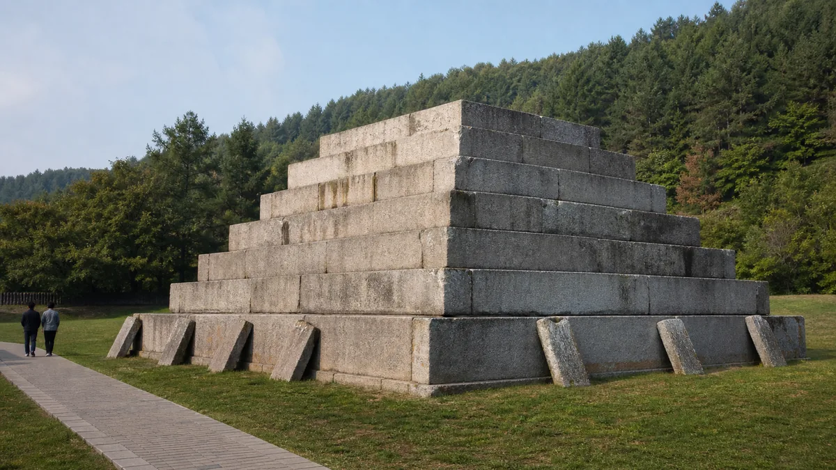
The stepped stone monument commonly called Jiangjunfen, the “General’s Tomb,” is frequently described as a royal mausoleum. Massive dressed blocks rise in receding courses, and large supporting stones help stabilise the structure. Walk around only on the authorised path and compare the tight joints, displaced stones and modern protection. The engineering is observable; the exact identity of the occupant is not. King Jangsu is among the proposed associations, but the tomb has no universally accepted inscription naming its owner.
Nearby names can sound more certain than the evidence. “Great King’s Tomb,” “General’s Tomb” and numbered tomb labels may be conventional archaeological or local designations rather than verified biographies. Grave robbery, collapse and incomplete records have removed information. Use “attributed to,” “commonly called” and “possibly” when the label exceeds what surviving evidence proves.
These are burial places, not stone climbing frames. Do not sit on retaining blocks, step over low barriers or stage comic poses against a tomb. Keep drones grounded unless current rules explicitly permit them, and avoid photographing conservation work, security areas or the nearby border landscape where signs restrict it.
Murals survive precisely because access is limited
Elite tomb paintings extend the story beyond walls and battles. Surviving images can include processions, architecture, attendants, banquets, hunting, mythical creatures and celestial symbols. They are not a single illustrated “Goguryeo lifestyle.” A tomb programme expressed the status, hopes and cosmology of a particular patron at a particular time, and comparisons depend on date, location and burial form.
Pigment on plaster reacts to humidity, temperature, salts, microorganisms, light and the carbon dioxide carried in visitors’ breath. Opening a sealed chamber can change the microclimate that preserved it. For that reason, many original mural tombs are closed, tightly controlled or interpreted through replicas, panoramas and digital displays. A report that someone once entered does not create a promise for your visit.
Treat a good replica as a conservation tool. Compare the position of a painted figure with the chamber plan, look at how a ceiling motif changes the imagined space, and read which details were reconstructed. If an original chamber is exceptionally open, follow limits on group size, time and photography without negotiation. Never use flash, touch plaster or lean equipment against a doorway.
Human remains and funerary objects deserve the same restraint. Speak quietly, do not photograph another visitor’s grief or discomfort, and explain to children that these were real graves. Preservation is not a barrier placed between you and history; it is the reason some evidence may remain for future study.
UNESCO’s 2004 inscription is larger than Ji’an’s ticketed sites
The official World Heritage name is Capital Cities and Tombs of the Ancient Koguryo Kingdom, inscribed in 2004. Its components include Guonei City, Wandu Mountain City and selected tombs in the Ji’an area—but also Wunu Mountain City at Huanren in Liaoning Province. Wunu is not a hidden corner of the Ji’an scenic area; it is a separate place requiring separate travel.
The distinction matters in both directions. Not every place marketed within a modern 5A tourism product is necessarily an individually named UNESCO component, and the World Heritage property is not exhausted by whatever a Ji’an combination ticket currently covers. Buffer zones, protected areas, visitor entrances and ticket categories serve different purposes.
There is also a separate UNESCO property in the Democratic People’s Republic of Korea called the Complex of Koguryo Tombs, likewise inscribed in 2004. The shared year and related culture do not make the two listings one admission system or one administrative site. Use UNESCO’s precise titles when comparing them.
World Heritage recognition does not certify every popular story. Its value lies in the exceptional capital-city system, fortifications, tomb forms, art and material evidence. The responsible response is to protect context: a wall in relation to terrain, a tomb within a cemetery, and an inscription within the politics of commemoration.
Choose the route by terrain, not by checklist
For a first full day, begin with Wandu in the cooler part of the morning if the trail and weather are suitable. Continue to Guonei for the plain-city contrast, then use a vehicle for the stele and principal royal-tomb stops. This order puts the hardest walking first. If visibility, rain or ice makes the mountain unwise, begin in town and treat the tomb-and-stele zone as the day’s core.
For a short visit, choose Guonei plus the Gwanggaeto Stele and one major tomb. Those three encounters establish city, text and burial without pretending to cover the whole landscape. For a mobility-conscious route, prioritise staffed, level interpretation areas and ask exactly how far the path runs from the drop-off point; “accessible entrance” does not guarantee a step-free circuit around every monument.
Driving distances are not the same as straight lines on an archaeological map. Arrange a taxi or car by named stop, keep the driver’s number, and confirm whether waiting is possible at the mountain gate. Public and scenic-area transport, through-tickets, reservations, passport checks and last admission can change. Verify them through the current Ji’an cultural-tourism or site notice, especially in winter and around holidays.
Carry water, sun or rain protection and a downloaded map. Mobile reception and translation are not substitutes for agreeing on a pickup point. Food and toilets are easier to find in town than beside every cemetery stop; use facilities when available rather than assuming the next site has them.
To extend the regional story, compare how terrain shapes memory at Changbai Mountain, how a living religious complex frames remembrance at Liuding Mountain, or how twentieth-century rule was staged at the Puppet Emperor’s Palace.
Photograph relationships, then let the stones keep their silence
The strongest photograph here is rarely a stone isolated from its setting. At Guonei, include a modern street edge to show how the ancient city and present Ji’an overlap. At Wandu, place a person safely on the path—not on the wall—to make slope and distance legible. At a stepped tomb, use an oblique corner view so two faces reveal construction. At the stele, record the whole surface, label and light direction before chasing individual strokes.
Soft side light can clarify joints and relief, but weather controls it. Do not promise yourself a sunset from a site that may close earlier, and never cross a barrier for a cleaner foreground. Tripods, drones, flash and photography inside shelters or tombs may be restricted. Follow the rule posted at that specific zone on that day.
Before leaving, return to the first joint you studied—if not physically, then in your last photograph. You may now see that the distance between Guonei and Wandu was part of a defensive idea, that the distance between a royal title and a damaged character contains scholarly disagreement, and that the distance between a tomb name and a known person must sometimes remain open.
Ji’an does not ask the stones to say more than they can. Its deepest lesson lies in their weight, their separation and the discipline of stopping where the evidence stops. Lower the camera for one minute. Let masonry, mountain and burial ground occupy their proper distances from one another—and from us.
Location profile
Where it is

Frequently asked questions
Is the Ji'an Goguryeo scenic area one enclosed attraction?
No. The 5A tourism label brings together separate archaeological zones around Ji'an, including Guonei City, Wandu Mountain City, the Gwanggaeto Stele and groups of royal and noble tombs. Entrances, tickets and transport arrangements can differ by zone, so ask for the current site map rather than expecting one continuous park.
How much time should I allow for the Goguryeo sites in Ji'an?
A selective route through Guonei City and the main stele-and-tomb stops can take much of a half day once transfers are included. A full day is more comfortable if you also want to climb Wandu Mountain City and read the interpretation carefully. Opening, last entry and weather-related access can change, so leave slack in the schedule.
Can visitors enter the mural tombs or photograph inside them?
Do not assume so. Ancient tomb murals are extremely vulnerable to humidity, carbon dioxide, light and physical disturbance, and many chambers remain closed or are represented by replicas and digital displays. Any opening and photography policy can change for conservation; follow the notice at each tomb and never use flash where it is prohibited.
What is the easiest way to travel between the sites?
Guonei City is the easiest urban stop, while Wandu Mountain City and the eastern or northeastern tomb zones require separate transfers. A taxi, hired car or current scenic-area transport is usually more practical than trying to walk the whole landscape. Show the Chinese names of each stop, agree where you will be collected and confirm current gate locations before setting out.