Jilin · Changbai Mountains
Changbai Mountain: Tianchi Between Fire and Weather
At Tianchi's rim, trace the dark caldera wall before looking for the perfect reflection, then choose one mountain approach rather than mistaking three distant entrances for one loop.
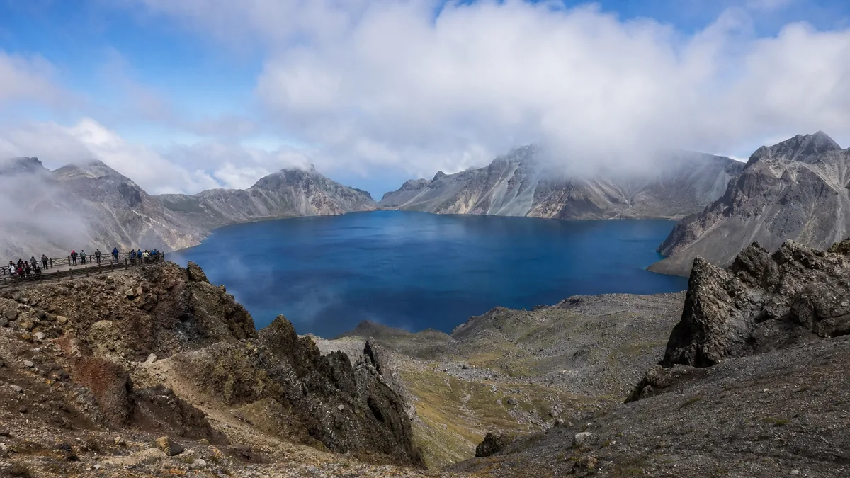
5A View location, maps and nearby scenic areasWhen the cloud opens above Tianchi, do not zoom in first. Lower the camera for ten seconds and trace three lines with your eyes: the near rim beneath your feet, the blue or steel-grey lake far below, and the opposite wall fading into weather. That pause reveals more than a reflection photograph. You are looking into a volcanic caldera whose water and rim cross an international boundary.
The next thing to observe is the sky. A shadow can travel across the lake in seconds; fog can erase the opposite wall almost as quickly. At Changbai Mountain, weather is not scenery added to the attraction. It decides which road runs, which platform opens and whether Tianchi appears at all.
Choose one side before choosing sights: China’s north, west and south routes begin at separate gates reached by long road transfers. They are not branches of one summit trail. The east side lies in the DPRK, not at another Chinese scenic-area entrance.
A single caldera, several names and two countries
In a China-based itinerary, Changbai Mountain or Changbai Shan is the clearest name for the Jilin scenic area. The same volcanic massif is commonly called Paektu in North Korean romanisation and Baekdu in South Korean romanisation. Tianchi is also known as Cheonji in Korean. These are not competing labels for different lakes.
The China–DPRK boundary passes through the mountain and Tianchi. A Chinese visitor ticket gives access to managed viewpoints on the Chinese side; it does not make the whole caldera a Chinese park or provide a route around the lake. Conversely, using Paektu or Baekdu in a Korean cultural context should not be treated as a claim that the Chinese scenic area has moved.
This distinction matters in English, where “Changbai Mountains” can also mean a much longer range across northeast Asia. The Changbai Mountain 5A scenic area is a managed visitor destination within that geography. Its 5A profile and map is an orientation point, not the boundary of the volcano, reserve, geopark or mountain range.
Read three heights before comparing the mountain
Tianchi’s surface is commonly placed at about 2,189 metres above sea level. The highest summit on the full caldera rim is usually listed around 2,744 metres and lies on the DPRK side. Baiyun Peak, commonly described as the highest peak on the Chinese side, is about 2,691 metres. None of those numbers is the “height of Tianchi”: one measures lake-surface elevation, while the others measure particular summits.
Published figures can differ by a few metres because maps use different survey datums, spellings and definitions of the summit being counted. Older signs may also round aggressively. The useful mental picture is therefore a lake close to 2.2 kilometres above sea level, enclosed by a broken rim that rises several hundred metres higher—not one cone with one universally agreed summit number.
The lake covers roughly ten square kilometres and is hundreds of metres deep at its deepest point. From a high platform, a wide-angle lens makes it look flatter and smaller. Put a section of rim, a marked path or a consenting human figure in the frame and the scale returns.
The 946 eruption is a turning point, not the whole origin story
Changbai is a layered volcano built through many eruptive phases. Basaltic lava helped form a broad foundation; later, more silica-rich magma constructed and repeatedly altered the summit area. Tianchi occupies the summit caldera left by that long history, rather than a hole made in a single afternoon.
A very large explosive event, commonly dated to 946 CE, spread pale pumice and ash far across northeast Asia. It is often called the Millennium Eruption and ranks among the largest eruptions of the last two millennia. Scientific work continues to refine its season, erupted volume and effects, so a precise day or a single dramatic strength number should be treated cautiously. The eruption greatly reshaped the summit, but later activity and erosion also modified what you see.
Look for evidence away from the famous lake: light volcanic fragments in exposed deposits, dark lava forms, a deep-cut canyon on the west route, mineral-stained thermal ground and the abrupt caldera walls. These features turn “volcano” from a label into a sequence—eruption, collapse, water, frost, river incision and forest recovery.
Changbai remains an active volcanic system monitored by scientists. That does not mean an eruption is expected during an ordinary visit. It means hot springs, seismic observation and emergency rules belong to a living geologic landscape, and closures should be read as risk management rather than lost entertainment.
Follow water and trees down the volcanic slopes
Tianchi has an outlet on the north side. Water passes into the upper river system and then drops at Changbai Waterfall, where spray, snow and rockfall can change the safe viewing line. Across the wider massif, streams contribute to the headwater landscapes of the Songhua, Yalu and Tumen river systems. Statements that one tourist platform is the single simple “source” of all three flatten a more complicated network of springs, tributaries and naming traditions.
The ascent is also a compressed lesson in latitude and altitude. Lower slopes support mixed broadleaf and conifer forest; higher belts become cooler conifer forest, then wind-shaped Erman’s birch near the treeline, and finally low alpine tundra around the exposed summit. The boundaries shift with aspect, wind, snow and disturbance, so they are zones rather than painted contour lines.
On the vehicle climb, watch tree form instead of only checking the summit forecast. Trunks shorten, branches bend, and forest breaks into low vegetation. That vertical sequence can still make a clouded day worthwhile. In the short alpine growing season, flowers and lichens survive close to the ground; leaving boardwalks or picking plants causes damage that takes far longer than a tourist season to repair.
In 2024, UNESCO designated Changbaishan UNESCO Global Geopark on the Chinese side. The designation recognises geological heritage, education and relationships between landscape and communities within its stated Chinese boundary. It is not a UNESCO boundary for the entire cross-border mountain, nor a judgement about sovereignty over Tianchi.
A sacred mountain with more than one inheritance
The Chinese name Changbai can be read as “ever white”; the Korean name Baekdu or Paektu as “white-headed.” Snow, pale pumice and the bright summit have all encouraged interpretations of that whiteness, but a neat etymology is not proof of one people’s exclusive origin story.
For Manchu tradition and the Qing imperial house, the mountain belonged to an ancestral geography of the northeast. Qing rulers sponsored surveys, restrictions and rites connected with Changbai, especially as the dynasty articulated the origins of the Aisin Gioro lineage. Court ritual made the mountain politically significant, but it should not be retold as if an emperor personally discovered an empty landscape. Hunters, gatherers, cultivators, medicine collectors and communities around the range had their own knowledge and movement.
In Korean cultural traditions, Baekdu is an ancestral and sacred mountain associated with foundation narratives, pilgrimage, poetry, song and modern national symbolism. Those meanings are not identical in every period or among people in North Korea, South Korea, China’s Korean communities and the wider diaspora. A foundation legend can explain why a place matters without becoming archaeological proof.
Today Chinese-speaking guides may say Changbai, Korean-speaking visitors may say Baekdu or Paektu, and an international map may alternate among them. Listen for the context before correcting the speaker. The fair reading is not that one name cancels the others, but that one volcanic landscape carries several living memories and modern political sensitivities.
Choose north, west or south as separate journeys
The north route, commonly approached from the Erdaobaihe area, offers the most varied first visit. When conditions allow, managed mountain vehicles continue towards a Tianchi viewpoint; lower links commonly include Changbai Waterfall, geothermal springs, pools and a forested valley. Internal vehicles cover distance, but stops, transfers, walking sections and one-way controls still require time. Thermal water and unstable ground are reasons to stay behind barriers.
The west route, usually planned from the Songjianghe side, reaches a broad caldera view by a long, exposed staircase and boardwalk. It can feel more gradual in the vehicle and more demanding at the final ascent. The west-side canyon and seasonal alpine flowers provide a strong second story, but blossoms, clear views and every path opening cannot be fixed to a calendar.
The south route reaches another high rim from a much more condition-dependent approach. Its more limited operation reflects snow, wind, road maintenance, ecology and border-area management. It can offer a quieter angle when open, yet it is a poor choice for an inflexible one-day plan unless current official information is clear. Do not treat the east slope as a fourth Chinese ticket: it is on the DPRK side and requires an entirely different national travel context.
For two routes, allow separate days and plan accommodation and road transfers around the actual gates. Never use a map’s straight-line distance across the crater to estimate a drive. Tickets, identity-document handling, internal vehicles and access rules can change; foreign visitors should confirm the current booking method with the official scenic-area service and carry the passport used for the reservation.
Let visibility and your body set the turnaround point
A clear weather icon in a base town does not guarantee a clear rim. Mountain cloud can build locally, wind can stop summit vehicles, and snow or ice can affect one slope while another remains open. Start early when practical, but do not turn “morning is better” into a promise. Give the lower forest, waterfall or canyon enough value that a closed rim does not destroy the day.
At roughly 2,200–2,700 metres, many visitors will not develop severe altitude illness, yet rapid vehicle ascent can still bring headache, nausea, dizziness or unusual breathlessness. Walk slowly, drink normally, keep warm and descend or seek help if symptoms worsen. People with heart or lung conditions should discuss altitude and cold exposure with a clinician before travel rather than relying on a generic tour label.
Vehicles reduce distance; they do not create step-free travel. The west route has a sustained staircase, while the north and south routes can still involve slopes, thresholds, crowded transfers and uneven or icy boardwalks. Wheelchair users and people with limited stamina should ask which viewpoint, lift or accessible vehicle is actually operating that day, where step-free toilets are, and whether a companion can remain with them through transfers.
Carry warm and waterproof layers even in summer, plus sun protection: thinner air, reflective cloud and open tundra increase ultraviolet exposure. Keep hands free on steps. In storms, high winds or poor visibility, turning back is not a failure to “complete” Changbai; it is the correct way to read the mountain.
Photograph the edge without crossing it
For Tianchi, make one wide frame that includes the broken rim, then a tighter image of cloud or snow moving across the wall. Reflections are strongest only under particular light and wind, so do not let the hunt for a mirror surface erase the geology. On the north route, falling water against dark rock explains drainage; on the west route, a human-scale stair or canyon layer explains distance better than a saturated blue lake alone.
Stay behind rails and border or ecological markers even when another visitor steps across. Crater edges can combine loose volcanic material, ice and sudden gusts. Drones may be restricted by protected-area, aviation and border rules; confirm current permission rather than launching from an apparently empty platform. Avoid photographing checkpoints, staff or other visitors closely without consent.
Visitor pressure is visible in more than queues. Summit tundra is easily trampled, geothermal ground can be dangerous, and water quality depends on waste control across the watershed. Carry rubbish down, do not feed wildlife, do not pick alpine flowers and do not make shortcuts between boardwalk bends. Guides, drivers, rangers, cleaners and nearby residents keep the experience functioning; weather delays do not make them responsible for an invisible lake.
Return to the rim with less certainty
For a wider Jilin journey, Liuding Mountain shows how ritual, heritage and a modern visitor landscape meet in another Korean Chinese region. The Goguryeo sites at Ji’an move the cross-border story into archaeology and tomb landscapes, while Jingyuetan offers a lower, human-shaped forest-and-water counterpoint near Changchun.
Before leaving Tianchi’s edge, look once more without asking the cloud to perform. The water may be blue, grey or absent; the opposite rim may sharpen and disappear within a minute. What should remain is restraint: this is a lake inside an active volcano, a watershed under pressure, a border, and a sacred landscape with more than one name. Let the weather keep part of it from you.
Use the LoreLens App at Changbai Mountain to recognise landforms on site and hear the human histories beyond the crater view.
Location profile
Where it is

Frequently asked questions
Which Changbai Mountain entrance should I choose?
Choose the north route for the broadest mix of Tianchi access, waterfall, hot-spring geology and forest; the west route for an exposed stair approach and a wide caldera view; or the more condition-dependent south route for a quieter high rim. They are distant road entrances, not one walking circuit, so confirm current opening and transport arrangements before booking.
Is Tianchi guaranteed to be visible?
No. Cloud, fog, wind, snow, road safety and visitor controls can hide the lake or close the summit transfer even when lower areas remain open. Keep a worthwhile lower-mountain plan and treat a clear view as a weather window rather than something the ticket guarantees.
Can I visit the north and west routes in one day?
It is usually more sensible to give one full day to one route. The gates use different road approaches and internal transport systems, and queues or weather delays are unpredictable. Two routes normally require separate days and accommodation or transfers planned around the correct entrance.
How difficult and accessible is a Changbai Mountain visit?
Vehicles cover substantial parts of some routes, but they do not remove high altitude, cold, ultraviolet exposure, slopes, stairs or uneven boardwalks. The west rim is especially stair-heavy. Visitors with heart, lung or mobility concerns should ask the official service for that day's vehicle, step-free platform, toilet and wheelchair details before choosing a route.