Hubei · Enshi
Enshi Grand Canyon: Two Levels of Living Karst
Read the canyon from Qixingzhai's cliff-edge paths to the water-filled depth of Yunlong Ground Fissure, with honest route choices, geology, weather and access advice.
5A View location, maps and nearby scenic areasStand still when the sound of Yunlong’s water first rises through the trees. You may not yet see the bottom of the fissure, but the echo already tells you that this is not simply a valley viewed from above. Later, on Qixingzhai, the narrow pillar called Yizhuxiang—“One Stick of Incense”—will appear almost weightless against open air. The same day can place you below falling water and beside a cliff edge.
That vertical reversal is the key to Enshi Grand Canyon. It is also the reason to plan the park as two demanding landscapes rather than one scenic stroll.
Orient yourself before committing. Qixingzhai is the high route of ridges, cliff paths and isolated rock towers. Yunlong Ground Fissure is the lower route of stairs, wet rock, waterfalls and enclosed sound. Combining them means repeated vertical change; a cableway, lift or escalator can shorten a particular segment, not erase every step.
Two landscapes share one ticket name
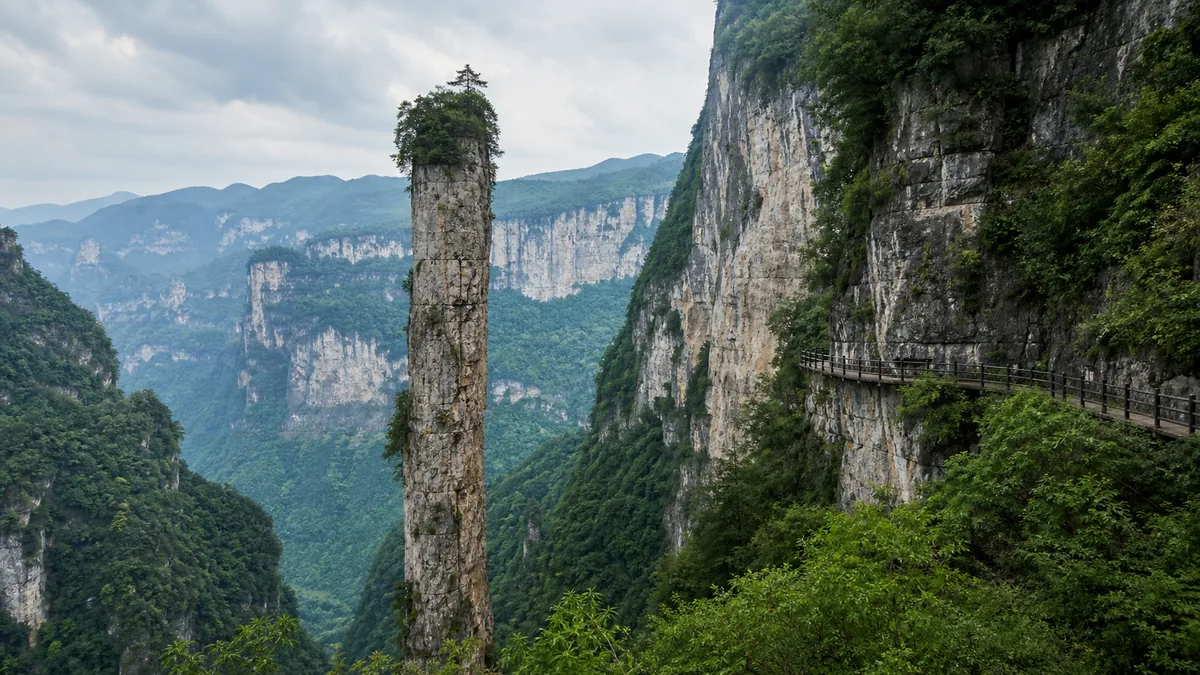
Qixingzhai gives the expansive view. Its path moves across high karst terrain, sometimes close to exposed edges, with distant folds of green mountains behind freestanding pillars. Yizhuxiang is the visual climax, but the sequence matters: changing angles reveal that a “needle” is a three-dimensional body separated from the wall by joints and erosion.
Yunlong Ground Fissure turns that viewpoint inside out. Here you descend into a narrow incision where streams, spray and shade dominate. Waterfalls can be more or less forceful with recent rain, and the sound often reaches you before the view. The enclosing walls make distance difficult to judge; wet stairs and bridges make foot placement more important than the next photograph.
Park maps, entry arrangements and the operating direction of visitor transport can change. Treat the two names as separate route modules and ask three questions at the visitor centre: which entrances are in use today, which mechanical aids are operating, and what is the last return connection from the section you plan to finish.
How the Qingjiang basin built a three-dimensional karst
The visual drama begins with carbonate rock, including limestone, laid down in ancient marine environments and later raised and fractured by tectonic movement. Rainwater absorbs carbon dioxide from air and soil, becoming weakly acidic. Given time, it follows bedding planes and cracks and dissolves the rock rather than merely wearing its surface smooth.
Those processes do not work alone. Fractures direct water; underground drainage enlarges openings; the Qingjiang and its tributaries cut downward as regional relief develops. Unsupported roofs and cliff faces can then collapse. What remains is a vertical system of ridges, pillars, caves, sink-like depressions, ravines and fissures—different levels of one drainage history rather than a collection of unrelated curiosities.
At Yunlong, look for water tracing a structural weakness. At Qixingzhai, look across the gap between a tower and the main wall and imagine cracks being widened grain by grain, then blocks falling away. Geologists may refine the age and sequence of individual forms, so the useful onsite explanation is a process chain—fracture, dissolution, incision and collapse—not a single dramatic event.
The Qingjiang eventually joins the Yangtze. That wider watershed matters: water seen in a scenic fissure is part of a living drainage system affected by rainfall, soil, vegetation and human land use well beyond the railings.
Yizhuxiang: measure with care, not slogans
From the first good side angle, use a person on the path or a tree at the base as scale. Yizhuxiang is commonly promoted as a limestone pillar roughly in the order of 150 metres high and only a few metres across at its narrowest. Those figures are useful for conveying proportions, but published numbers do not always state where the top, base or minimum width was measured. Repeat them as approximate promotional dimensions, not survey-grade precision.
The pillar’s survival is sometimes explained with claims that it is “unshakable” or uniquely stable. The less theatrical explanation is better. Resistant beds, the orientation of joints, gradual removal of surrounding rock and the present load shape all contribute to what stands today. None makes a fractured natural pillar permanent. Freeze–thaw, rain, roots and small rock failures continue to alter karst cliffs, and site monitoring matters.
The same caution applies to comparisons with the Grand Canyon of Colorado or phrases such as “the world’s most beautiful canyon.” They are tourism analogies, not measurements. Colorado is a vast river-cut canyon system in different rocks and climate; Enshi’s distinctive experience is the rapid switch between enclosed fissure, vegetated limestone wall and isolated tower. It does not need a borrowed superlative to be legible.
One boundary is also worth fixing on the map: Xiaozhai Tiankeng is not inside Enshi Grand Canyon. It lies in Fengjie, Chongqing. The broader border region contains connected karst stories, but an impressive nearby landform should not be turned into a stop on this park’s route.
A living prefecture, not an ethnic backdrop
Enshi is the seat of the Enshi Tujia and Miao Autonomous Prefecture. Tujia, Miao and Han residents, along with members of other communities, live and work in the region now. They are farmers, drivers, engineers, guides, hotel staff, shopkeepers, teachers and park workers—not surviving figures from a frozen folk scene.
Tourism can widen income through homestays, food, transport, guiding, maintenance and performance. It can also concentrate work in busy seasons, raise land-use pressure and ask residents to package selected dress, dance or architecture into a short visitor-facing “culture.” A scheduled show can be skilled contemporary labour and still not represent everyday life in every village. Ask before photographing individuals, learn the name of a craft or song rather than calling it simply “tribal,” and do not treat costume as proof that a person is available to perform.
Conservation also involves choices. Limits on construction, farming, forest use or access can protect slopes and water while changing how nearby households use land. More visitors support jobs but add traffic, waste, noise and demand for water. A responsible guide does not solve that balance in one paragraph; it makes the people doing the balancing visible.
Qu Yuan’s “search”: a regional echo, not a site legend
One of the most quoted lines in Chinese comes from Li Sao, attributed to the Chu poet Qu Yuan:
路漫漫其修远兮,吾将上下而求索。
“The road ahead is long and far; I will search high and low.”
This was not written about Enshi Grand Canyon, and it should not be presented as an inscription or local origin story. Qu Yuan belonged to the literary and political world of ancient Chu, and Li Sao stages a speaker’s long moral and imaginative journey through loyalty, slander and exile. “High and low” is a search for a worthy path, not hiking advice.
The modern echo is everywhere in education and public speech: the line now expresses persistence in inquiry when the route is difficult. It fits Enshi only as an honest borrowed lens. After descending toward Yunlong and climbing again on Qixingzhai, the words gain physical weight—but the landscape illustrates the quotation; it did not produce it.
Choose one of two realistic routes
Route A — lower-world focus. Choose Yunlong Ground Fissure if your priority is water, enclosing rock and a shorter commitment. Allow generous time for controlled descents, photography stops and the climb out. “Shorter” does not mean flat. Recent rain can make the route more atmospheric and more slippery, while high runoff may lead to restrictions. Confirm where you will exit and how you return before going down.
Route B — full vertical day. Combine Qixingzhai with Yunlong only if your group can sustain a long day of steps, exposed walking and transfers. A sensible principle is to give fresh legs and the clearest forecast window to Qixingzhai, then enter the fissure only if time, weather and knees remain comfortable. The park may prescribe a different sequence through tickets or transport, so adapt rather than forcing an online itinerary.
On Qixingzhai, optional cableway or escalator segments can save energy when open. At Yunlong, lifts may bypass a specific height difference. None should be advertised as making the combined route step-free. Do not calculate your day from the last admission alone: shuttle, cableway, lift and exit connections can have different final operating times. Photograph or write down the day’s last-return information at the entrance.
If your party has different abilities, splitting the day is a valid choice. One person can take the confirmed shorter module while another completes the high route, then meet at an agreed staffed point. Staying together out of politeness is not worth a fall on wet stone.
Weather changes the route, not just the view
Mountain weather can turn a clear ridge into dense fog quickly. Fog softens the landscape but removes depth cues at cliff edges; keep behind barriers and do not step backward for a photograph. Thunderstorms are more serious. Qixingzhai contains exposed high sections where lightning, wind and heavy rain can prompt closure. Follow staff directions immediately rather than sheltering under an isolated tree or waiting for the “dramatic light.”
In Yunlong, rain increases spray and runoff. Stone steps, metal plates and wooden surfaces may become slick. Water can also loosen debris on steep walls. Barriers, rockfall warnings and temporary closures are active safety measures, not obstacles to a complete checklist. Never cross a closure for an uncrowded waterfall shot.
Carry water, a light rain layer and shoes with reliable wet grip. Keep both hands available on long stairs; a small backpack is safer than loose shopping bags. Summer heat and humidity can drain energy even under cloud, while colder seasons can leave shaded surfaces unexpectedly slick. Check the scenic area’s same-day notice, not only a generic city forecast.
Finally, work backward from the last operating connection. Allow a buffer for queues, slow steps and weather holds. If staff advise turning around or omitting a section, the right response is to preserve an exit margin, not to rush the most technical part of the route.
Photograph depth without sacrificing footing
At Yizhuxiang, begin wide. Include a path, railing or human figure to show the pillar’s relationship to the cliff. Then move to a side angle where separation from the background is clear; a long lens can flatten the gap and make the formation look like a decoration pasted onto the wall. Mist can simplify the scene, but do not promise sunrise, cloud sea or visibility on a fixed date.
In Yunlong, expose for bright falling water and let the shaded walls remain dark enough to retain depth. A slower shutter can soften water, but only from a stable, permitted stopping place—never in the flow of a staircase. Wipe spray from the lens before assuming the misty frame is atmospheric. Sound is part of the place too: record ten seconds without narration where stopping is safe, and you will preserve something a still image cannot.
Drone rules, tripods and restricted sections can change. Confirm current rules with staff. Do not fly near people, wildlife, cliffs or transport infrastructure without explicit permission, and never climb a barrier to remove it from the composition.
Accessibility and ecological etiquette begin before the gate
Visitors who use wheelchairs, walking aids or have limited stamina should request a segment-by-segment description: vehicle boarding, gradients, stair counts, surface conditions, toilet locations, emergency exits and the return path. “There is an elevator” answers only one of those questions. Ask whether the same accessible facility will still be operating when you return and whether weather can close the connecting route.
For anyone with vertigo, Qixingzhai’s edge exposure may matter more than total distance. For knee or balance concerns, Yunlong’s wet descents and climbs may be the limiting factor. Trekking poles may be restricted or awkward in crowded stairs; check before relying on them. There is no failure in choosing a viewpoint instead of completing both modules.
Karst soil can be thin and vegetation slow to recover. Stay on built paths, take every wrapper out, avoid feeding wildlife and keep voices low near nesting or resting animals. Do not touch fresh mineral deposits, stack stones, enter caves or side paths behind barriers, or wash anything in the stream. Water links the visible fissure to places you cannot see; what enters it does not remain “inside the attraction.”
Leave with the canyon correctly placed
Before leaving, look once more at the level you have crossed. From below, water found fractures and deepened them. From above, dissolution and collapse isolated towers from walls. Between those levels, workers keep paths open and nearby communities negotiate what tourism should protect, display and change. Enshi’s grandeur is not a claim that it is the biggest or most beautiful; it is the ability to make a drainage system feel three-dimensional under your feet.
For coordinates, map context and nearby 5A sites, open the Enshi Grand Canyon Scenic Area profile. Continue west toward the water-cut Chongqing Lesser Three Gorges or Qutang Gorge, or compare another cliff-and-water walking landscape at Ba Li Gou Scenic Area.
Choose the next canyon by its geology and route, not by a superlative. Then give your final minute here to the sound that opened the day: water working patiently below the path.
Location profile
Where it is

Frequently asked questions
Are Qixingzhai and Yunlong Ground Fissure the same walk?
No. Qixingzhai is the high, exposed cliff-and-pillar route; Yunlong Ground Fissure is a lower, enclosed route beside water and waterfalls. Visiting both usually adds substantial descent, ascent and transfers, even when mechanical aids are operating.
Can lifts and escalators make Enshi Grand Canyon step-free?
Do not assume so. Cableways, lifts or escalators may remove particular climbs, but they do not turn the complete park into a continuous step-free route. Confirm current accessible sections and return arrangements with the scenic area before buying a combined itinerary.
What happens if there is fog, heavy rain or a thunderstorm?
Fog can erase long views, while rain makes stone and metal steps slick and can increase runoff and rockfall risk. Exposed sections or transport may close. Follow staff instructions and confirm the day's route status rather than treating a ticket as a guarantee of access.
Is Xiaozhai Tiankeng inside Enshi Grand Canyon?
No. Xiaozhai Tiankeng belongs to the wider karst region but is in Fengjie, Chongqing, not inside this scenic area. It should not be inserted into an Enshi Grand Canyon walking plan as an in-park stop.