Henan · Xinxiang
Baligou: Water, Cliffs and the South Taihang Climb
Follow a South Taihang stream from lower pools toward the season-dependent Tianhe Waterfall, then choose stairs, cliff routes and operating scenic transport without mistaking a vehicle ride for a step-free day.
5A View location, maps and nearby scenic areasAt the lower stream in Baligou, look beyond the first bright pool and find the horizontal lines running across the cliff. Water occupies the bottom of the scene, but the layered wall sets its direction. As you walk upstream, broad family-friendly sections can tighten into wet steps, cliff paths and a much larger vertical climb.
The scenic area lies in the South Taihang Mountains of Huixian, within Xinxiang. Baligou—roughly “bah-lee-go”—means “Eight-Li Valley,” but the name is not a modern measurement of your public walking route. One modern li is about 500 metres; entrances, open circuits and transport stops have changed beyond any simple four-kilometre promise.
Read the visit in levels: begin with the lower stream and pools; decide whether current water makes the main waterfall worthwhile; then choose an upper, cliff-side or return route according to knees, weather and the last operating transport. A shuttle or lift covers a segment, not the whole day.
“Eight-Li Valley” is a place-name, not a step count
Baligou’s visitor map can look linear: gate, stream, waterfall, upper ground. The lived route is more complicated. Scenic vehicles may connect an outer entrance with a transfer point; walking trails branch along the canyon floor; stairs and engineered cliff sections gain height; an operating lift or another vehicle may serve only one transition. The order and sales packages can change.
Do not turn the name 八里沟 into arithmetic. Historical Chinese distance units varied, place-names often outlive the path that inspired them, and the managed scenic boundary is not identical to one old valley track. A “short” distance on a flat map also says nothing about vertical gain.
This matters at the first ticket or transport decision. Ask which sub-areas are open, where the included vehicle actually stops, whether a separate ride is needed for the upper return and how much stair walking remains. Save the Chinese name of your last boarding point. “Entrance,” “visitor centre” and “parking area” may refer to different levels.
Baligou is best treated as a full South Taihang canyon day rather than a quick waterfall stop. A shorter visit can work if you deliberately turn around in the lower valley. It becomes a poor plan when a visitor assumes every named sight lies beside one continuous bus road.
Layered rock explains the walls better than a superlative
The South Taihang rises sharply above the plains of northern Henan. At Baligou, stacked sedimentary layers, fractures, uplift and stream erosion help produce high walls, benches and narrow drainage lines. Different beds resist weathering differently: harder layers project as ledges while weaker material retreats.
Look for that pattern before attaching a resemblance name to every rock. Horizontal bedding gives the cliffs their constructed appearance. Near-vertical joints guide seepage and blocks. Fallen material at the base records gravity and freeze-thaw or rainfall processes, while pools mark places where water meets more resistant rock or a change in gradient.
Tourism descriptions sometimes use phrases such as “the finest canyon in the Taihang” or compare the landscape with distant world-famous parks. These are promotional judgements, not geological measurements. The better comparison is within your own route: the width of the lower valley against the confined waterfall approach, or a person against one repeated rock bed.
The landscape is active, not a finished stone exhibit. Rain can move sediment, loosen rock and change a stream channel. Protective nets, retaining structures and closed sections are evidence of management in a dynamic canyon, not blemishes to crop from its story. Never collect rock or enter a taped-off talus slope.
The lower valley teaches you how much water is really present
Lower Baligou is where to calibrate expectations. Pools, small cascades, planted or natural shade, bridges and broad paths make the first section easier than the upper climb. Names such as Taohua Bay—Peach Blossom Bay—may evoke a season, but flowers, colour and clear water depend on timing and conditions.
Watch the stream rather than an advertising poster. Is water crossing the full lip of a small cascade or confined to one groove? Are rocks recently wet above the current line? Is fine sediment clouding a pool after rain? These observations tell you more about the day’s hydrology than a photograph made in another month.
Small barriers, channels and visitor works may also influence how water appears. A pool can be beautiful and partly managed at the same time. Do not describe every sheet of water as untouched, and do not assume engineering makes the whole valley artificial. The present scene combines bedrock, seasonal inflow and maintenance.
This lower section is the sensible turnaround for visitors who want water and cliff scale without committing to the long upper route. Even here, wet stone, bridge thresholds and crowding can complicate mobility. Ask where the next unavoidable stairs begin before a comfortable path quietly becomes a demanding one.
Tianhe Waterfall is a height claim, not a flow promise
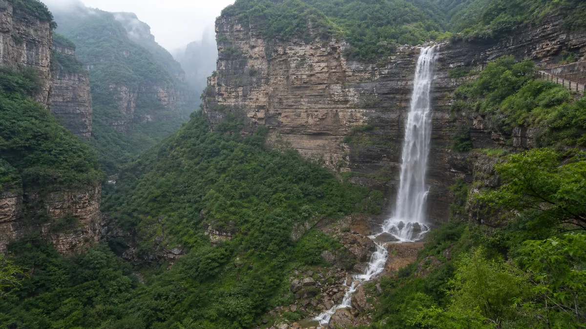
The main waterfall is usually called Tianhe Waterfall, “Milky Way” or “Heavenly River” Waterfall. Scenic material commonly promotes a drop of about 180 metres. Published numbers may count different starting and ending points or use the full stepped cliff, so treat the figure as an approximate advertised drop rather than a survey you can verify from one viewpoint.
More important, height and volume are different measures. A long rock face can carry only a narrow thread in a dry period. Rain can broaden and strengthen the fall, yet heavy rain can also trigger flash-flood controls, rockfall concern and trail closure. “Go immediately after a storm” is unsafe advice in a confined mountain drainage.
Approach only on the open route. Spray makes stone and metal steps slick, and wind can move the falling water sideways. Keep electronics secured and one hand available for a rail. Do not climb onto a wet boulder to remove other visitors from the frame.
If flow is low, the cliff still repays attention. Trace the notch where water leaves the upper level, dark moisture stains, vegetation that follows seepage and the rubble below. They show how intermittent water uses the wall. If the route is closed, accept a distant view or change plans; a barrier is not evidence that staff are hiding the “real” waterfall.
Reaching upper ground changes the route, not just the view
Above the main canyon, visitor maps may point toward high paths, the Red Stone River area and return connections on another level. Reaching them can require long stair sequences, steep ramps or a cliff-side engineered passage. The upper surface feels unexpectedly open after the vertical enclosure below, which is precisely why the transition consumes energy.
Scenic buses, lifts or other mechanical transport may reduce particular climbs when open. They should be understood as separate links in a chain. A ride can end before another stairway; its arrival platform may not be the same place as the next bus; a ticket can be separate; wind, lightning, inspection or crowd control can stop operation.
Choose between a lower-canyon route, a waterfall-focused route and a full upper circuit. The lower option gives pools and cliff scale with less ascent. The waterfall option adds wet surfaces and more stairs. The full circuit rewards visitors with contrast between canyon bottom and high terrain, but requires the largest time, knee and transport margin.
Do not let a one-way section make the choice for you accidentally. Photograph the route board, ask whether your path returns to the same gate and confirm the last descent or transfer. If you are already tired at the waterfall, turning around on an approved route is better than treating an operating lift as a guaranteed rescue.
Taihang poetry describes difficulty, not this exact trail
For Chinese readers, the Taihang Mountains carry the idea of a formidable barrier as well as scenery. Tang poet Li Bai wrote, “I would cross the Yellow River, but ice blocks the stream; / I would climb the Taihang, but snow fills the mountains.” The lines appear in Hard Is the Road, not in a Baligou travel diary.
Li Bai had served briefly at the imperial court and left amid frustration. In the poem, he sets down his cup, imagines the river and mountain obstructed, then turns toward hope: “A time will come to ride the wind and cleave the waves.” The landscape is a metaphor for a blocked life; the consequence is not surrender but a declaration that a route may reopen.
The poem still echoes in the expression xinglu nan—“the road is hard”—used far beyond hiking. At Baligou, it clarifies why an apparently simple valley becomes a sequence of decisions about height and passage. It does not prove Li Bai climbed this stair or saw Tianhe Waterfall.
That distinction preserves both literature and place. Read the verse as a cultural lens, then read today’s trail through physical evidence: the angle of stairs, wet rails, transport queues and staff closing a route when weather makes the “hard road” genuinely dangerous.
Water scenery depends on work, ecology and restraint
The view contains more people than the photograph. Local residents, path builders, drivers, cleaners, waterfall-route staff, rangers and rescuers make a large canyon visit possible. Roads and mechanical transport can spread tourism income and reduce some walking, while also concentrating traffic, construction and waste.
Streams support plants and small animals whose needs do not match a visitor’s desire for maximum flow. Water management, dry weather and downstream use can all influence what reaches one ledge. Without site-specific records, it is unfair to assign every change to one cause. Observe current conditions and keep uncertainty visible.
Visitor restraint is practical conservation. Stay on the open path, carry waste out, do not stack stones in the stream, pick plants or release fish and other animals. Avoid soaps and food in pools. Loud speakers and drones can disturb people and wildlife; drone rules may change and should be checked locally.
Crowds also change risk. A wet stair that is manageable alone becomes harder when people stop in both directions for photographs. Let faster groups pass only at a wide point, keep children away from open water edges and never use a closed maintenance path as a shortcut.
Weather and stamina should choose the day’s circuit
An effective full-day sequence starts with the lower valley, reassesses water and weather, continues to Tianhe Waterfall if open, then commits to upper ground only with enough time for the confirmed return. This keeps the most consequential choice late enough to use real conditions but early enough to protect the last transport.
Summer may provide green vegetation and stronger flow, but also heat, thunderstorms, flash-flood closures and slippery rock. Autumn can bring clearer air and colour, neither guaranteed. Winter may reveal cliff structure and reduce crowds while adding ice and suspended transport. Spring water and blossoms vary with recent weather.
Check dated official notices before leaving and the current board at the gate. Ask about trail closures, scenic vehicles, lift operation, last return and whether rain is forecast upstream as well as where you stand. A blue patch overhead does not prove a narrow drainage is safe.
Carry permitted water, sun and rain protection, footwear with grip and an offline copy of the gate name. Leave time for queues and slow stair descent. If knees, balance or vertigo become a problem, tell staff at an operating point rather than waiting until a closed or one-way section limits choices.
Photograph the vertical transition without stepping outside it
In the lower valley, use a bridge or person to compare pool width with cliff height. A low angle can connect water to horizontal bedding, but keep the camera and body behind barriers. Reflections change with cloud and sediment; a polarising filter can reduce glare but may also remove the water’s visual depth.
At Tianhe Waterfall, a longer lens can show the water against dark moisture stains without requiring a risky approach. Include a section of path for scale. On the climb, let repeated stairs or a cliff-side structure lead the eye upward. Those visitor works explain access and should not automatically be hidden.
Accessibility is route-specific. Entrance transport can help visitors who cannot walk the outer road, but it does not certify the waterfall or upper circuit as step-free. Expect possible boarding gaps, stone thresholds, long stairways, steep slopes and wet surfaces. A lift, if running, may bypass only one height difference.
Wheelchair users and travellers with limited mobility should ask staff for a precise same-day circuit, accessible toilets, vehicle boarding support and a return that does not depend on stairs. Families should verify stroller suitability beyond the lower path. No one should promise the main waterfall viewpoint until the open route and assistance have been confirmed.
Leave by measuring water against stone
Before leaving, return your attention to the layered wall above the stream. At the beginning it may have seemed like a backdrop for water. After the route, it has become the structure that holds ledges, stairs, seepage lines and the choice between valley and upper ground.
Baligou does not need to be “China’s most beautiful canyon” to matter. Its value lies in a readable South Taihang transition: broad lower water, a narrowing approach, a high fall whose volume changes, and the physical work of gaining another level. Tourism infrastructure makes that sequence accessible while also revealing its limits.
Make the last photograph from a legal stopping point. Keep one person, bridge or stair in the composition, and let the water occupy only the amount of the frame that the day actually provides. That honest proportion will remember the canyon better than borrowed superlatives or a waterfall promised by an old poster.
Use the Baligou 5A profile for a map anchor. Continue to Yuntai Mountain for a separate red-gorge and summit system, to Baoquan for a contemporary canyon resort where engineered attractions need their own reading, or to the Red Flag Canal for another South Taihang landscape shaped by labour and water infrastructure.
Location profile
Where it is

Frequently asked questions
How much time should I allow for Baligou Scenic Area?
A substantial day is the safest plan if you want the lower canyon, the main waterfall area and an upper or cliff-side extension. Internal vehicles can shorten selected road sections but do not remove transfers, queues, stairs or walking. Confirm the open route and final return before setting out.
Does Baligou's Tianhe Waterfall always have strong flow?
No. The waterfall is commonly promoted with a drop of roughly 180 metres, but that figure describes advertised height rather than guaranteed volume. Rainfall, season and water management affect the flow; storms can increase danger and close the very route visitors hope to see.
Can scenic buses or lifts make Baligou step-free?
Do not assume so. Buses and mechanical transport, when operating, serve particular segments. Boarding gaps, transfers, sloping paths, wet surfaces and long stair sequences can remain between stops. Ask staff about a specific accessible circuit and return option for that day.
Is Baligou a good place to visit immediately after heavy rain?
Heavy rain may make waterfalls look fuller, but it also raises the risk of flash flooding, rockfall, slippery paths and operational closure in a confined canyon. Follow dated official notices and on-site barriers; never enter a closed watercourse for a stronger photograph.