Jilin · Da'an
Da'an Nenjiang Bay: Read a Wetland That Refuses to Stay Still
Follow reed edges, old channels, embankments and birding zones through an urban-edge Nen River wetland shaped by floods, sediment, restoration and water control—not an untouched wilderness frozen in one perfect state.
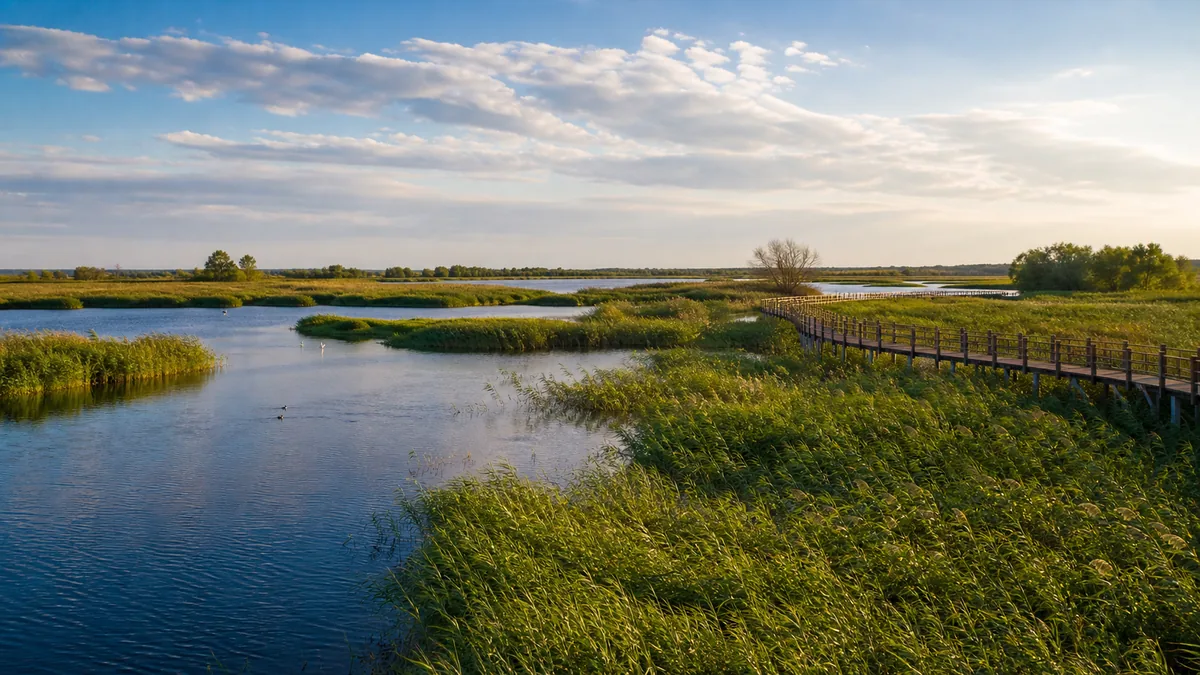
5A View location, maps and nearby scenic areasBefore photographing the widest view, identify four lines. Reeds make a ragged, breathing edge. A darker stain or strip of debris marks a recent water level. A shallow curve through grass may be an old channel. A long line that stays almost unnaturally straight is probably an embankment, road or managed bank. Together they reveal what Da’an Nenjiang Bay is: a living river-wetland system and a designed visitor landscape at the city’s edge.
The mistake is to choose only one half. Calling it an untouched wilderness erases dikes, gates, planted banks, boardwalks, patrols and the people whose homes and work depend on water management. Calling it an artificial park erases floods, sediment, ice, reed succession and migrating animals that do not follow a tourism timetable. The site is valuable precisely because natural processes and human decisions remain visible together.
Read the bay in four layers: begin at the open waterline, continue through a reed-wetland route, give the quiet bird zone more distance than time, and finish from a slightly higher viewpoint where old curves and straight infrastructure can be compared. Confirm which layers are open before setting out; water, boats, vehicles and boardwalk access all change.
A river bend is a process, not a blue shape on a map
The Nen River crosses a low plain where gradient, seasonal flow and sediment allow channels to shift. Faster water erodes an outer bank; slower water deposits sand and silt elsewhere. During high water, flow can spread across low ground, enter side channels or reconnect a depression. When a channel migrates or is cut off, an old curve may remain as a pond, marsh, wet meadow or faint hollow.
That basic process explains why a “bay” can contain open water, mudflat, reed bed, grassland and willow edges within one view. The proportions are not permanent. A wet spring, a dry period, a managed release, a blocked inlet or several seasons of plant growth can move the visible boundary. One year’s aerial image is evidence for that date, not a timeless plan.
Ice is part of the river’s work too. Freeze-up, breakup and moving floes can push against banks and structures. Thaw water travels over frozen soil before it can soak in, while wind redistributes snow across open ground. Never infer winter safety from a flat white surface; channels, springs and inflows can leave thin places invisible from shore.
Published area, “wetland percentage,” plant totals and bird-species counts can differ because sources use the tourism area, wetland-park boundary, monitoring zone or a particular survey period. Unless a label names the boundary and date, treat a large number as a prompt to ask how it was measured—not as the main reason to value the wetland.
Flood, sediment and water-control structures shape the same view
The river supplies water and sediment, but contemporary Nenjiang Bay also sits within flood-control and land-use systems. Embankments reduce risk to urban districts, roads and farmland. Gates and channels may drain, retain or deliver water. Their operation can protect people and influence how long shallow areas remain wet.
No single structure explains every change. Upstream conditions, local rain, drought, ice, channel geometry, vegetation, pumps and gates can all matter. If one reed bed looks dry, do not announce that a dam “destroyed the wetland” from one visit. If a pool is full, do not claim restoration is permanently complete. Ask what season, management action and monitoring period the interpretation describes.
Look for the contrast between curves and straight lines. A sinuous low swale may record earlier river movement; a ruler-straight bank often indicates deliberate control. Culverts, sluices and channel junctions show how water crosses infrastructure. Keep outside operational areas and do not approach a gate for a dramatic photograph: currents and slippery concrete can be dangerous even when the surrounding water appears still.
The modern echo is practical rather than romantic. Each decision about retaining water, clearing a channel or strengthening a bank balances flood safety, habitat, agriculture, water quality and public access. Different years require different trade-offs. A managed wetland is not a failed wilderness; it is a place where those choices should remain visible and open to evidence.
Restoration opens habitat—and access changes habitat
Wetland restoration may reconnect water, reshape banks, remove waste, manage invasive plants, establish native vegetation or create shallow-water mosaics. Boardwalks and designated viewpoints concentrate foot traffic so people can see the site without trampling every shore. Patrols, litter collection and fire management keep a city-edge wetland functioning under heavy use.
Every intervention also has costs. A path fragments cover and carries noise into a quiet area. Night lighting can alter animal behaviour. Landscaping can favour tidy edges over the irregular structure some species need. Water held for an attractive view may not match the depth or timing required by all plants, fish and birds. Restoration should therefore be judged by monitoring and adaptive management, not by how green a promotional photograph looks.
Reeds illustrate the dilemma. Dense stands provide shelter, nesting cover and filtration, but uniform reeds can also dominate open shallows; dry stems add fire risk; management may cut, burn or open sections under controlled plans. A cleared patch is not automatically ecological damage, and a wall of reeds is not automatically perfect habitat. Ask what goal the work serves and whether a quiet refuge remains elsewhere.
Tourism facilities make stewardship more public. They can fund maintenance and help visitors understand floodplain processes, yet popularity adds traffic, waste, sound and pressure for spectacle. Stay on the designed route, carry out what you bring, and accept a seasonal closure as habitat management rather than poor service.
This is a worked landscape, not an empty stage for wildlife
The wetland sits beside a city and within a wider agricultural and fishing region. Local residents live with flood warnings, dust, winter cold, insects and the benefits of open water. Fishers and farmers have practical knowledge of seasonal conditions, while regulations may now limit when and where older uses continue. Avoid turning livelihoods into a nostalgic “traditional scene” for a camera.
Rangers and ecological monitors read water levels, nesting activity, fire risk and visitor behaviour. Maintenance workers repair boards, clear hazards and collect rubbish. Boat or vehicle operators translate the day’s operating limits into real routes. Their presence is evidence of management, not proof that nature has disappeared.
Visitors enter this social landscape too. A person who feeds birds changes their behaviour; a photographer who steps off the boardwalk creates a new path; a loud group can empty a roost before anyone notices. “I was only here for a minute” is multiplied by thousands of visits.
If you speak with residents or workers, ask permission before portraits and do not block work for a posed scene. Rules about fishing, collecting plants, cycling, pets, fires and picnics can differ by zone. Follow current signs rather than copying what one person appears to do beyond a barrier.
Each season redraws water, reeds and the visitor map
Spring can bring thaw, high water, mud and migrating birds, but timing varies with temperature, snow, rain and upstream flow. Some paths may close just when the wetland appears most dynamic. Give birds extra room during migration and nesting; depleted animals need feeding and rest more than they need to complete a visitor’s checklist.
Summer can produce tall reeds, intense sun, sudden rain, lightning and heavy insect activity. Open water may be partly hidden from low paths. Carry drinking water, sun protection and repellent, and wear clothing that reduces bites without relying on aerosols near other visitors or wildlife. Leave an exposed platform when thunder approaches; a view is not worth waiting beside metal railings.
Autumn may open sightlines as vegetation changes and can bring another migration period, but wind across the plain can make observation difficult. Winter turns water and reeds into strong graphic forms, yet ice, wind chill and shortened operations narrow the safe route. A cleared entrance does not mean every boardwalk, tower or shoreline is open.
Seasonal change also explains why species totals are a poor promise. A checklist combines observations across years, habitats and survey effort. On one visit you may see a few common birds behaving naturally; that can be more informative than a disturbed rarity pursued by a crowd.
Good birding is measured by distance, not by the length of a list
Begin with the naked eye, then binoculars. Watch where birds repeatedly land, feed or disappear into reeds before lifting a camera. If heads rise, feeding stops, alarm calls spread or a flock shifts away, you are already too close. Step back without waiting for flight.
Do not play recorded calls, whistle responses, throw food or direct a boat toward birds. Playback can pull territorial birds away from nests and use energy; feeding changes diet and concentrates disease; chasing a flock repeatedly denies it rest. Never approach a nest, eggs or young, and avoid publishing an exact nest location.
A long lens is an ethical tool only when the photographer also stays on the authorised route. It is not permission to push through reeds for a lower angle. Use a beanbag or hand support if tripods are restricted, silence camera sounds where possible, and keep conversation low in designated quiet zones.
Drones can disturb birds far beyond the operator’s apparent distance. Their use may be restricted by wetland-protection rules, aviation controls and local airspace requirements. Confirm explicit permission before launch; an absence of a nearby “no drone” sign is not approval.
Choose a route by habitat, energy and the return journey
For a first visit, begin at a broad river-bend viewpoint. Find the waterline, sediment edge and any straight embankment before entering the reeds. Continue on an authorised wetland boardwalk, pause at the edge of the quiet bird zone rather than trying to penetrate it, and finish at a raised platform if it is open. The higher view helps connect old channels with modern control lines.
For a bird-focused visit, choose fewer stops and wait longer. Ask staff which publicly accessible zone currently offers observation without approaching breeding or roosting areas. Do not demand directions to a rare bird. Weather and disturbance can make yesterday’s report irrelevant.
For a short or family route, combine one open-water stop with a firm, well-maintained boardwalk segment and return before fatigue. Children need close supervision beside rails and soft banks. A scenic train, electric vehicle or boat may reduce walking when operating, but none should be treated as guaranteed transport home.
Before boarding any boat, check life-jacket fit, wind policy, route and landing point. Stay seated when instructed and do not ask the operator to cross a buffer for a photograph. Internal vehicles, boats, remote gates and boardwalks can close because of flood, low water, wind, lightning, ice, maintenance or wildlife protection. Confirm the last return before moving away from the entrance.
Safety and accessibility must be checked one segment at a time
Riverbanks can be undercut, muddy or deceptively firm above soft sediment. Remain behind rails and back from unprotected edges. Floodwater can cover paths, hide holes and carry debris; never enter a closed section because the water looks shallow. During lightning, leave towers, boats, open shorelines and isolated trees for a substantial shelter.
Strong wind and sun are common risks on exposed ground. Secure hats and loose gear, hydrate and protect skin even in cool air. After rain, wooden boards, algae and mud become slippery. In winter, frost and ice collect first in shade and at bridge joints. Never step from a formal path onto river ice as a shortcut.
An “accessible” scenic area can still contain difficult transitions. Confirm each planned section: curb or ramp at the entrance, boardwalk gradient and cross-slope, gaps between planks, passing width, resting places, thresholds, accumulated water or ice, vehicle boarding and accessible toilets. Wheelchair users and people with low vision may need different information; ask for current conditions, not a generic accessibility label.
Mosquitoes and other biting insects can be intense near still water. Long sleeves, repellent used according to its label and a check for ticks after brushing vegetation are sensible. Do not spray insecticide onto plants or over other visitors. Carry essential medication, and remember that a distant platform may not have shade, drinking water or staff.
Photograph change, then leave the wetland room to change again
Photograph relationships rather than trophies. From a high point, place a curved old channel beside a straight dike. At reed height, use the waterline and wind-bent stems to show movement. A person on the legal boardwalk can provide scale; a bird flushed from cover is evidence that the photograph failed ethically.
Side light can reveal reed texture and sediment, while overcast weather can hold detail in water and sky. Neither condition is guaranteed, and opening hours may not match sunrise or sunset. Do not cross a barrier for reflected colour, and do not geotag a sensitive nest or roost. Ask before using tripods or making commercial images.
Continue through Jilin’s water and forest stories at Chagan Lake, compare a deliberately planted urban recreation forest at Jingyuetan, or follow water from high volcanic terrain around Changbai Mountain. Each landscape asks a different question about nature and management.
Before leaving Nenjiang Bay, return to the four lines from the opening. The reed edge may move by the next season. The water mark records a level that has already gone. The old channel remembers a route the river abandoned, while the straight embankment records a decision people made to limit movement.
The wetland’s value is not an inflated bird list or a claim of absolute wildness. It lies in change—and in the restraint required to witness change without forcing water, birds or people to perform. Lower the camera, keep your distance and let the next line be drawn without you standing on it.
Location profile
Where it is

Frequently asked questions
Is Da'an Nenjiang Bay an untouched natural wetland?
No. It is a Nen River bend and wetland landscape beside the city, managed through a wetland-park and tourism framework. Seasonal floods, sediment and former channels interact with embankments, gates, drainage or supply channels, restoration planting, boardwalks and visitor facilities. The mix can support habitat and public access without being pristine wilderness.
When is the best time to see birds and open water?
There is no guaranteed peak. Migration, breeding, water level, reed growth, weather and zone closures change what can be seen. Spring and autumn can bring movement, while summer vegetation and winter ice create different views, but a particular species or flock is never assured. Check recent park notices and observe quietly with binoculars or a long lens.
Do boats and internal sightseeing vehicles always operate?
No. Boats, electric vehicles and individual boardwalk sections may stop because of water level, wind, lightning, ice, maintenance, habitat protection or low-season schedules. Ask at the entrance which zones are open, where the last return departs and whether a ticket covers each service before travelling to a distant stop.
Is Nenjiang Bay accessible for wheelchairs or safe to cross on winter ice?
Accessibility must be checked section by section: an accessible entrance does not guarantee suitable boardwalk gradients, joint widths, dry surfaces, transfers or toilets throughout the park. Never treat river or wetland ice as a visitor route unless an officially managed area is explicitly open; current, springs, inflows and thaw can weaken ice that looks solid.