Jilin · Songyuan
Chagan Lake: The Net Beneath the Winter Ice
Follow one rope away from an official ice hole to imagine the huge net moving unseen below, then look beyond the winter catch to a shallow wetland sustained by collective skill and restraint.
5A View location, maps and nearby scenic areasIn winter, stand inside the official viewing area and find a small dark hole in the white ice. Do not approach it. Instead, follow the direction of the rope with your eyes until it disappears. The important object is mostly invisible: a long net being guided beneath the frozen surface by a crew spread across the lake.
In a warmer season, perform a different version of the same exercise. Choose the line where open water meets reeds, mud or grass. That shifting edge reveals a shallow lake whose area and habitat can change when wind, inflow and managed water level change. At Chagan Lake, the most useful lines are often the ones you cannot treat as permanent.
Use two maps: the visible map contains ice holes, shore paths, reed beds and visitor barriers; the working map contains underwater rope, net wings, fish movement, channels and safe load zones. Stay on the visible visitor route and let trained crews manage the second.
Chagan Nur is a Mongolian name before it is an English brand
The lake is also called Chagan Nur or Chagan Nao’er. In Mongolian, nuur means “lake,” while chagan—also encountered in forms such as tsagaan—is commonly associated with “white.” “White Lake” is therefore a useful gloss. Chinese 查干淖尔 preserves the sound through Chinese characters, while “Chagan Lake” replaces the second Mongolian element with English.
Spelling varies because Classical Mongolian, modern dialects, Chinese transcription and different Romanisation systems do not produce one inevitable English form. Local explanations may add ideas such as purity, brightness or sacred value. Those meanings can matter culturally without becoming a literal dictionary translation or proof of one exclusive naming story.
The lake lies in Qian Gorlos Mongol Autonomous County, within Songyuan. “Mongolian culture” here is not a costume label added for tourists. It includes language, place names, fishing knowledge, pastoral and agricultural histories, food, family memory and present-day livelihoods. Ask how residents name the water rather than using one translated phrase to speak for every household.
The Chagan Lake 5A profile and map establishes the scenic area’s location. It does not define the entire hydrological lake, wetland, fishery, reserve or every community around the shore.
A shallow lake changes when the measuring line moves
Chagan Lake is commonly described as covering around three hundred square kilometres, but that figure should begin a question, not end one. Does it count open water on a particular date, reed beds and marsh, the managed fishery, or a wider scenic and wetland boundary? In a shallow basin, a modest vertical change can move the horizontal shoreline a long distance.
Wind can push water across shallow bays and resuspend fine sediment. Rain, evaporation, tributary inflow, drainage, water-supplement projects and control structures all influence level and water chemistry. Salinity or alkalinity can also differ by location and hydrological period. Calling the lake simply “freshwater” may be useful for tourism, but it should not erase local variation or a history of water stress.
Claims that Chagan is China’s “number X” lake vary for the same reason. Rankings may compare open-water area, freshwater lakes, inland lakes, wetlands or a single high-water survey. They also become stale when levels change. The physically honest description is a large, shallow wetland-lake system whose boundaries and chemistry respond to both climate and engineering.
Stand at one fixed post on the shore and look at the band below it. Wet sediment, bleached reeds, stranded plants or a sharp vegetation edge can reveal recent water position. The lake has not failed to match a brochure; it is showing the condition that determines fish habitat, bird feeding areas, boat access and the winter ice sheet.
An under-ice haul begins long before the net appears
Large-net winter fishing is often shown only at the climax, when fish surge from an opening. The work begins earlier. An experienced fishing leader—commonly described in Chinese as the yubaitou, or fishing master—chooses a site using accumulated knowledge of depth, bottom, water movement, oxygen and likely fish behaviour. Modern measurements can assist, but they do not turn selection into a push-button decision.
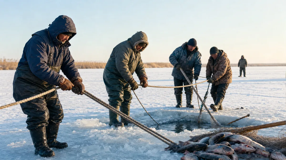
Crews cut a main entry and exit and a sequence of smaller working holes through the ice. A guiding pole is passed from hole to hole beneath the surface, carrying rope around a planned arc. The seine follows. Its wings spread under the ice and lead fish towards the collecting section. From above, visitors see scattered dark circles; below, those points join into a single controlled geometry.
At the exit, people, capstans or mechanical winches draw rope and net back towards the opening. Horses may appear in historical accounts and in some contemporary festival scenes, while vehicles and machinery are also part of modern work. The exact mixture changes. What does not change is the need for coordination: one rushed pull, tangled line or person in the wrong place can damage equipment or injure someone.
Fish then have to be lifted, sorted, handled and transported in extreme cold. Net makers, mechanics, drivers, safety staff, traders and cooks extend the labour beyond the ice crew. A photograph of the final catch compresses hours of preparation and many forms of skill into one instant.
Custom, ceremony and performance are related but not identical
The formal name “Chagan Nur Winter Fishing Customs”—查干淖尔冬捕习俗 in Chinese—appears on China’s national list of representative intangible cultural heritage projects. The protected subject is not one net or festival ticket. It is a body of knowledge, vocabulary, cooperation, ritual, material skill and community transmission.
Public events may include a lake-offering and net-awakening ceremony, blessings, music, dress, the appointment of a fishing master or a symbolic first catch. Some elements draw on regional Mongolian practice and fishing belief; some have been selected, standardised, enlarged or restaged for a modern audience. “Performed” does not automatically mean meaningless, but “old-looking” does not prove that every gesture has continued unchanged for centuries.
Promotional narratives sometimes push winter fishing back to one precise ancient dynasty or claim an unbroken thousand-year form. Historic fishing around northeast Asian lakes is not in doubt, yet a lineage for today’s exact ceremony, equipment and scale needs specific evidence. Engines, winches, safety controls, broadcast crews and tourism markets belong honestly in the present story.
Watch how participants themselves distinguish work from ritual. A blessing can express gratitude and risk; a song can carry language and belonging; a demonstration can teach visitors. Respect those meanings without treating local Mongolian residents as a permanent cast required to perform identity whenever a camera arrives.
A record catch is not a report on ecological health
A single net piled with fish is visually persuasive, but it cannot tell you whether the fishery is sustainable. Catch size depends on net placement, effort, stocked biomass, species mix, weather, market goals and management decisions. A record from one year should never be converted into a normal annual yield or a target every winter must exceed.
Fish stocking can support commercial harvest and local livelihoods, especially in a managed lake fishery. It also raises ecological questions: which species and sizes are released, whether genetic diversity is maintained, how stocked fish compete or feed, and whether catch limits and mesh rules allow the system to renew. Quantity is one management signal, not the whole ecosystem.
Water is the deeper constraint. Supplementary inflow and water-control projects can help maintain lake area or dilute salts, but they also connect Chagan to decisions elsewhere in the basin. Water quality responds to agricultural runoff, settlement wastewater, tourism waste, sediment and internal nutrient cycles. No ceremonial release of fish can substitute for clean, suitably timed water.
Reeds, shallow bays and mudflats support migratory waterbirds as well as juvenile fish and invertebrates. A healthy lake must retain more than harvestable biomass. Fisheries managers, wetland staff, scientists, fishers and communities therefore negotiate closed areas, timing, gear, stocking, habitat and visitor access—even when a giant catch receives the headline.
Outside winter, read shoreline, birds and everyday Gorlos life
Without the white ice stage, the lake’s shallow structure becomes easier to see. Reeds mark sheltered water, low banks reveal changing level and distant open water can look closer than it is. A shore route or boardwalk is the right place to compare these zones; entering reed beds creates disturbance and can hide deep mud or channels.
Spring and autumn can bring migrating waterbirds, while summer offers active wetlands and a broad horizon. Species, numbers and distance change by day, water level and disturbance. Use binoculars or a long lens, keep voices low and never use calls, food, drones or pursuit to force a bird closer. If a bird repeatedly looks at you, gives alarm calls or leaves a nest area, you are already too close.
Local culture is also present when no ceremony is scheduled. Place names, museums or interpretation, food businesses, fishing equipment, family stories and multilingual signs can tell more than a posed costume photograph. Ask before photographing people closely, pay fairly for products and guide services, and do not walk into a work yard or home because it appears “traditional.”
Warm seasons introduce their own practical limits: heat, strong sun, thunderstorms, mosquitoes and exposed shore wind. Boat, boardwalk, visitor-centre and cultural-program operations can change. Make the wetland itself the core of the day so an absent performance does not turn a living community into a missed attraction.
Choose an official winter view or a shore-based warm-season route
For a winter-fishing visit, begin with the current official event map, not a social-media pin. Use the designated transport and viewing zone, identify the entry and exit holes from a distance, then watch the rope sequence before the catch emerges. Leave before cold or crowding affects judgement. Event dates, catch times and fish quantities cannot be guaranteed.
For a winter landscape visit without a major haul, choose an opened shore or managed snow route. Ice, fishing work and horizon can still explain the lake. Do not roam towards distant machinery or follow tracks onto an unapproved part of the reservoir; work vehicles may use a route that has not been opened for public load.
For a warm-season half day, combine one defined shore or wetland walk with a local interpretation venue or settlement business that welcomes visitors. For a longer day, add a second shoreline zone only after checking road distance and opening. The lake is too broad for one scenic gate to reveal every habitat and community.
Shuttles, boats and temporary event transport serve particular segments. They may stop for wind, water level, maintenance, ice assessment or low demand. Confirm the named gate, return arrangement, toilet location and last practical connection with the official visitor service rather than assuming “Chagan Lake” identifies one compact arrival point.
Ice, wind and mobility impose hard limits
Winter ice is a work surface only after assessment and management. Thickness can vary near cracks, springs, inlets, outlets, pressure ridges and fishing holes. Snow hides those differences. Never drive onto the lake independently, follow a convoy through an open barrier or assume a parked vehicle proves general safety. Stay behind staff lines and obey an immediate retreat instruction.
Rope under tension, capstans, winches, horses and moving equipment create a second danger zone. Never stand inside a rope arc, step across a line, crowd an exit hole or approach fish for a close-up. Children need constant hand-level supervision. Wind chill can make exposed ice far colder than the town forecast; protect face and hands, use insulated footwear and keep a phone battery warm.
An official ice route is not automatically accessible. Snow ridges, slippery surfaces, long distances from shelter and vehicle steps can be serious barriers. Wheelchair users and visitors with limited mobility should ask about a firm viewing platform, accessible shuttle, boarding help, heated rest point and toilet for the exact event day. If those pieces are absent, a shore interpretation may be the safer and fuller visit.
In warmer seasons, a relatively level boardwalk may offer better access, but gaps, ramps, mud and long approaches still matter. Ask which section is step-free that day. Thunderstorms, heat and insects require water, sun protection, rain cover and repellent. No season justifies entering a closed wetland or working fishery.
Photograph coordination, not only abundance
Begin with the rope. From outside the safety line, use its diagonal to connect one small ice hole with workers farther away. A longer lens can show hands, breath and coordination without placing you beside the winch. Then make a wide frame that includes the crew, machinery or horses and the empty white distance. That space explains the scale hidden under the ice.
Do not block a capstan, horse route, vehicle, fish-sorting area or emergency lane. Never ask workers to repeat a dangerous action. Seek consent for identifiable close portraits, and caption a ceremony or demonstration as such. Keep drones grounded unless current event, aviation and wildlife rules explicitly allow them.
Beyond Chagan, Daan Nenjiang Bay offers another western Jilin wetland shaped by river movement and restoration; Jingyuetan shows how a reservoir and planted forest became an urban landscape; Changbai Mountain moves water and weather to a volcanic, cross-border scale.
Before leaving, look back at the first small hole. The spectacular fish are visible for minutes; the net, accumulated knowledge, water management and ecological limits remain mostly out of sight. Chagan Lake’s real scale is not the weight of one record haul. It is the number of people who must coordinate—and the restraint required to leave enough life in the lake after the rope stops moving.
Use the LoreLens App at Chagan Lake to recognise working zones, wetland edges and cultural interpretation while keeping a safe distance from fishing and wildlife.
Location profile
Where it is

Frequently asked questions
What does the name Chagan Lake mean?
Chagan Nur is commonly glossed from Mongolian as 'White Lake': chagan or tsagaan relates to white, and nuur means lake. Chinese Chagan Nao'er and English Chagan Lake reflect different transcription habits. Additional meanings found in local stories are cultural interpretations, so one neat translation should not be treated as the only origin account.
When can I see the winter fishing at Chagan Lake?
Large public winter-fishing activities are normally seasonal, but their exact dates, fishing areas and viewing arrangements depend on ice assessment, weather, fisheries management and event operations. Check the scenic area's current official notice rather than planning from a previous year's festival calendar.
Is it safe to drive or walk onto Chagan Lake ice?
Only enter an ice route or viewing area explicitly opened and managed that day. Ice thickness varies near cracks, inlets, outlets and working holes, while wind and snow can hide hazards. Never drive onto the lake independently, follow a staff vehicle, cross barriers or approach net openings and tensioned ropes.
Is Chagan Lake worth visiting outside winter?
Yes. Warmer seasons reveal a shallow shoreline, reed and wetland habitats, migratory birds and the Mongolian culture of Qian Gorlos without the winter-fishing crowds. Water level, insects, heat, storms, bird presence and open boardwalks vary, so use a current shore route and keep well away from nesting or feeding wildlife.