Beijing · Tongzhou
Beijing Grand Canal: Reading China's Waterway at Tongzhou
Walk the North Canal waterfront where tribute grain once changed hands, then read the bridges, parks and new city skyline as the latest layer of a waterway built over many dynasties.
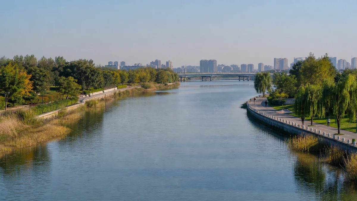
5A View location, maps and nearby scenic areasStand beside the North Canal in Tongzhou and watch the water move under a modern bridge. The towers on the horizon belong to Beijing’s new sub-centre; the paved banks, planted wetlands and flood-control works are contemporary. Yet for centuries, this was the threshold where grain, boats, officials and labourers approached the imperial capital.
That layered view is the subject of this guide. The Beijing (Tongzhou) Grand Canal Cultural Tourism Scenic Area, designated a National 5A scenic area in 2024, is a visitor area in one Beijing district. It is not the entire Grand Canal, not every canal-related site in Tongzhou, and certainly not one walkable attraction stretching from Beijing to Hangzhou.
Read one river reach in four directions: look along the water for transport, across it for bridges and flood control, back towards historic Tongzhou for warehouses and markets that have mostly vanished, then towards the new skyline for the canal’s latest urban role.
Begin with the boundary: Tongzhou is a gateway, not the whole canal
“Grand Canal” can mean several overlapping things: a historic system developed over many periods, the serial property inscribed by UNESCO, modern waterways still used for drainage or navigation, and local parks and cultural attractions carrying the canal name. Their boundaries are not identical.
This page focuses on Tongzhou’s 5A cultural-tourism area and the nearby waterfront context needed to understand it. The exact current visitor boundary, entrances and included venues should come from the official scenic-area map. Do not assume that a newly opened museum, every riverside park, a particular wharf or every old building nearby is automatically inside one ticketed zone.
For the scenic area’s map and coordinates, use the Beijing–Tongzhou Grand Canal 5A profile. Once on site, orient yourself by a chosen stretch of the North Canal rather than trying to “complete the Grand Canal.”
Tongzhou matters because it served as a northern transfer point and eastern gateway to Beijing. Cargo could arrive by water, enter warehouses, change boats or continue overland and through connecting waterways towards the capital. Its story is about movement between systems, not simply the endpoint of one blue line.
No emperor dug the Grand Canal in one campaign
The canal is better understood as a network assembled in stages. Regional rulers created early canals to link rivers and move troops or grain long before Beijing was the capital. These older works belonged to different political landscapes and did not yet form a single Beijing–Hangzhou route.
During the Sui dynasty, especially in the early seventh century, the state enlarged and connected major waterways between northern and southern regions. The works made long-distance movement of grain, officials and armies possible on an unprecedented scale. Emperor Yang is closely associated with this phase, but “one emperor built the whole canal” erases older channels, later rebuilding and thousands of workers.
The Yuan dynasty created another decisive turn after making Dadu—present-day Beijing—its capital. Engineers adjusted northern routes to serve the new political centre. The Tonghui Canal, associated with the engineer and astronomer Guo Shoujing and completed in the late 13th century, improved water access towards Dadu through a carefully managed chain of water sources and locks.
Ming and Qing governments continued repairing, dredging and administering the network. Channels shifted, silt accumulated, floods damaged infrastructure and sections rose or declined with policy. The Grand Canal is therefore a history of continuous maintenance, not an ancient trench that survived unchanged.
Tribute grain made Tongzhou an imperial logistics city
The key cargo was cáoliáng (roughly “tsow-lyahng”), tax grain transported to support the court, garrisons and population of the capital. Barges brought rice and other grain north from productive regions. Tongzhou’s waterways, wharves and granaries turned that flow into storage, accounting and redistribution.
Geography made transfer essential. Water levels, boat designs, canal conditions and access towards inner Beijing were not constant. Loads might change vessels, wait in storage or move by cart and connecting waterway. What looks from a modern bank like uninterrupted river travel was actually a chain of pauses, checks and handovers.
This system helped feed Beijing and bind distant tax regions to the centre. It also concentrated risk. Low water, ice, breached dikes, silt, delay or corruption could leave grain stranded and workers liable for losses. Canal logistics were never the frictionless conveyor belt suggested by a clean map.
Tongzhou grew around these flows. Merchants, inns, workshops and markets served boat traffic; official institutions supervised grain; religious and civic landmarks gave travellers a sense of arrival. A well-known local line, often translated as “one glimpse of the pagoda and you recognise Tongzhou,” connects the shadow of the Burning Lamp Pagoda with boatmen approaching the northern gateway. Treat it as local memory rather than a precise navigation record.
Follow the workers rather than only the rulers
Emperors and engineers appear in official histories, but canal transport depended on boat crews, trackers, stevedores, warehouse hands, cart drivers, shipwrights, lock keepers, dike builders and dredging labourers. Clerks measured grain and recorded losses; merchants financed trade around official transport; families maintained households while workers were away.
Their labour followed water and seasons. Boats could ground in shallow reaches, wait for a lock, fight currents or stop when winter froze northern water. Hauling, unloading and reloading grain meant repeated physical work, not a single voyage from field to palace.
The state tribute system and private commerce also overlapped. A boat travelling under official obligations could support markets along the route, while rules tried to control cargo, timetables and leakage. Opportunities and exploitation existed together: canal towns prospered, but workers could bear harsh quotas, danger and debt.
When you look across today’s quiet water, restore noise to the scene—ropes straining, grain sacks landing, hulls being repaired, officials calling measurements. The lost warehouses matter, but the human network that activated them matters more.
Read today’s waterfront as a changed river
The North Canal in Tongzhou is not an untouched survival from the Ming or Qing dynasty. Its channel, banks and water regime have been repeatedly altered by flood-control projects, dredging, modern bridges, roads, water management and ecological restoration.
That does not make the present river “fake.” It means its authenticity lies in accumulated use. A rebuilt bank can reveal how today’s city manages flood risk; a wetland planting can show new ecological priorities; an old alignment or pagoda view can retain historical orientation even when warehouses have disappeared.
Look for three layers at once. The water surface still provides the long view that made canal movement possible. The banks show engineered edges, parks and habitat projects. Beyond them, the sub-centre skyline announces Tongzhou’s new role within metropolitan Beijing.
The contrast with the Forbidden City is useful. The palace displays the destination of imperial supply; Tongzhou explains part of the system that brought food and materials close to its gates. One preserves ceremonial rooms, the other asks you to reconstruct logistics from a working urban landscape.
Ecological renewal brings benefits and choices
Modern river restoration can improve water quality, expand habitat, connect walking routes and return previously hard-edged banks to public use. Flood-control capacity and managed water replenishment can also make the waterfront safer and more continuous.
Every intervention, however, selects a new shoreline. Regrading banks, planting wetlands, restricting access and controlling flows can change fishing, informal use and older visual patterns. A green riverbank is not automatically the original canal ecosystem restored to a timeless state.
Observe where paths are set back for vegetation, where concrete remains necessary for flood management and where new bridges interrupt or frame the historic line. These trade-offs are the modern equivalent of older canal maintenance: keeping water useful requires decisions about who and what the river serves.
Wildlife, seasonal water and planted landscapes are dynamic. Stay on marked paths, avoid entering restoration areas and do not promise yourself a particular bird, flower or water level from someone else’s photograph.
The sub-centre is another canal-era reinvention
Beijing’s development of Tongzhou as a municipal sub-centre has brought government functions, transit, housing, offices and major cultural buildings eastward. The canal is no longer mainly a grain artery, but it again helps organise where institutions and public spaces gather.
New landmarks such as the Beijing Grand Canal Museum, library and performing-arts venues make this transformation visible. They should not be casually treated as one attraction with identical hours or as permanent components of the 5A boundary. Each may have its own reservation, security, closure and exhibition rules.
The museum can add vital objects, maps and reconstructed contexts that the open waterfront cannot supply. The river, in turn, prevents museum history from becoming a sequence of models behind glass. If combining them, check the current museum booking and route separately rather than assuming a canal-park ticket covers both.
Compare this reuse of monumental planning with the Beijing Olympic Green. Both places express a contemporary urban ambition through axes, cultural buildings and public space. Tongzhou’s difference is that its organising line is a working and remembered waterway far older than the new district around it.
Choose one of three realistic visit shapes
A short waterfront visit can focus on one accessible North Canal promenade. Walk in one direction for 60 to 90 minutes, cross at a bridge if practical, and return by a parallel bank or the same path. This makes room to observe details instead of treating the riverside as a race.
A half-day historical route can combine a river segment with a canal-related historic node such as the Burning Lamp Pagoda area, where current public access allows. Heritage compounds, road crossings and the river may not form one seamless pedestrian precinct, so verify entrances and choose transport before committing.
A longer cultural day can add a park section or the Beijing Grand Canal Museum. Treat it as two or three separately operated visits. The distances are substantial, and a map’s green blocks can hide closed gates, construction or long detours.
Metro, bus, taxi, bicycle and walking can all be useful, depending on the chosen segment. Current exits, bike rules, parking, last entry and riverside closures can change. Start with a precise destination—not “Grand Canal”—and save the return location in Chinese for a driver or navigation app.
Boats, wharves and events are conditional
A sightseeing boat can make the transport history intuitive: bridges become height limits, curves change visibility and the city moves at water speed. But boat service depends on approved routes, water conditions, maintenance, demand, seasons and ticket arrangements.
Do not build the day around an old timetable or travel video. Confirm which wharf is operating, whether the trip is one-way or return, how tickets are issued and where the boat actually goes. A “canal cruise” may cover only a selected reach and does not recreate the historic journey to Hangzhou.
The same caution applies to festivals, evening lighting, markets and waterfront performances. They can animate the space without being permanent features. Phrase them as possible current programming and check organisers directly.
If boats are not running, the visit has not failed. Walk to a bridge, look at the clearance beneath it and follow the towpath-like edge. The mechanics of a transport corridor remain visible from land.
Photograph connections, and make access part of the plan
From a bridge or designated overlook, use the river as a leading line between an older landmark and the new skyline. On the bank, include cyclists, anglers or walkers at a respectful distance to show that the canal is public space, not an empty historical stage.
Morning or late light may reflect more softly, but haze, wind, water level and illumination vary. Do not step onto unstable edges, flood-control structures or planted wetlands for symmetry. Drone and professional photography rules may differ by park, bridge and government-adjacent area; follow current signs.
Many promenades are level, but the full waterfront is not uniformly step-free. Bridge ramps, road crossings, construction barriers, distance between toilets and seating, and access to boats or museums require separate checking. A smooth photograph of one section does not establish accessibility for the whole scenic area.
Weather changes the experience quickly. Summer heat and limited shade can make long distances tiring; rain or snow can make decks and embankments slick. Carry water, choose a turnaround point and leave enough energy for the final transfer.
A canal is a practice, not only a monument
Return to the moving water. It does not look like a palace because the canal’s achievement was never a single façade. It was coordination: rivers connected, grain measured, boats repaired, workers organised, banks repeatedly rebuilt and political centres supplied.
Today’s Tongzhou continues that pattern under different priorities. Flood control, ecological repair, recreation, museums and sub-centre construction have replaced tribute grain as the dominant programme. They bring public benefits while changing the shore once again.
The honest way to see the Beijing Grand Canal is not to imagine an untouched ancient river or to celebrate every new project as automatic progress. See a corridor repeatedly negotiated between water, labour and state ambition. Then watch one boat, bird or reflection pass through the frame—and remember that movement, not stillness, made this place.
For another Beijing landscape shaped by water and power, continue to the Summer Palace, where a court transformed a lake for pleasure, ceremony and political display.
LoreLens App can help identify canal landmarks and bridges in Tongzhou, then connect the modern waterfront with the grain workers and water managers who made it function.
Location profile
Where it is

Frequently asked questions
Is the Beijing Grand Canal 5A scenic area the entire Grand Canal?
No. The National 5A designation awarded in 2024 refers to a cultural-tourism scenic area in Tongzhou, Beijing. The historic Grand Canal is a vast waterway system extending through multiple provinces and periods. Confirm the scenic area's current official map because its visitor components should not be assumed to include every nearby park, museum, wharf or heritage site.
Can visitors take a boat on the Grand Canal in Tongzhou?
Sightseeing boats can operate on selected Tongzhou reaches, but routes, wharves, seasons, water conditions, maintenance and ticketing can change. A cruise is therefore a possible addition rather than the basis of a fixed itinerary. Check the official operator's same-day information before travelling to a pier.
How much time should I allow for the Tongzhou canal waterfront?
A focused riverside walk can take two to three hours, while a longer day can add a park section or a separately operated museum. The waterfront is extensive, and attractions that look close on a schematic map may require a substantial walk or transfer. Choose one river segment first and verify current entrances and transport.
Is the Grand Canal Museum part of the 5A scenic area?
Do not assume that every new cultural building in Beijing's sub-centre is a fixed component of the 5A boundary. The Beijing Grand Canal Museum is a major place to understand the waterway, but its opening, reservations, exhibition access and relationship to a scenic-area ticket should be checked directly with the museum and current official scenic-area information.